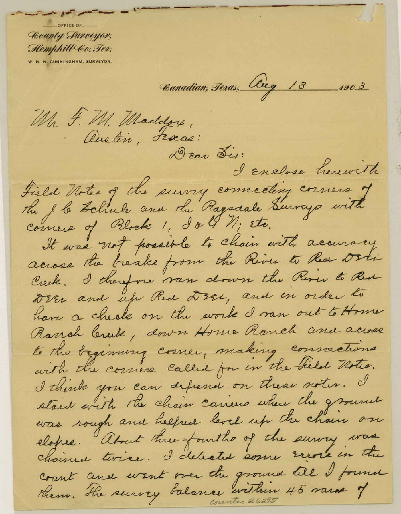
Hemphill County Sketch File 5
[Connecting line in Block C]
-
Map/Doc
26295
-
Collection
General Map Collection
-
Object Dates
8/13/1903 (Creation Date)
8/13/1903 (Correspondence Date)
-
People and Organizations
W.H.H. Cunningham (Surveyor/Engineer)
-
Counties
Hemphill
-
Subjects
Surveying Sketch File
-
Height x Width
11.2 x 8.8 inches
28.4 x 22.4 cm
-
Medium
paper, manuscript
-
Features
Red Deer Creek
Home Ranch Creek
Part of: General Map Collection
Padre Island National Seashore, Texas - Dependent Resurvey

Print $4.00
- Digital $50.00
Padre Island National Seashore, Texas - Dependent Resurvey
2001
Size 18.4 x 24.1 inches
Map/Doc 60553
Live Oak County Working Sketch 30

Print $20.00
- Digital $50.00
Live Oak County Working Sketch 30
1988
Size 19.0 x 25.9 inches
Map/Doc 70615
Kinney County Working Sketch 44

Print $20.00
- Digital $50.00
Kinney County Working Sketch 44
1978
Size 36.7 x 25.8 inches
Map/Doc 70226
Gillespie County Working Sketch Graphic Index

Print $20.00
- Digital $50.00
Gillespie County Working Sketch Graphic Index
1945
Size 38.0 x 47.4 inches
Map/Doc 76553
Edwards County Working Sketch 68

Print $20.00
- Digital $50.00
Edwards County Working Sketch 68
1957
Size 28.7 x 26.8 inches
Map/Doc 68944
Morris County Rolled Sketch 2A

Print $20.00
- Digital $50.00
Morris County Rolled Sketch 2A
Size 24.3 x 19.1 inches
Map/Doc 10241
Karnes County Rolled Sketch 1

Print $20.00
- Digital $50.00
Karnes County Rolled Sketch 1
1943
Size 27.5 x 25.7 inches
Map/Doc 6452
Castro County Sketch File 4g

Print $4.00
- Digital $50.00
Castro County Sketch File 4g
Size 12.0 x 8.9 inches
Map/Doc 17477
Sherman County Rolled Sketch 4

Print $20.00
- Digital $50.00
Sherman County Rolled Sketch 4
Size 23.1 x 31.7 inches
Map/Doc 7786
Flight Mission No. CUG-3P, Frame 30, Kleberg County

Print $20.00
- Digital $50.00
Flight Mission No. CUG-3P, Frame 30, Kleberg County
1956
Size 18.5 x 22.2 inches
Map/Doc 86235
Liberty County Sketch File 12

Print $6.00
- Digital $50.00
Liberty County Sketch File 12
1858
Size 9.6 x 12.5 inches
Map/Doc 29907
Calhoun County NRC Article 33.136 Sketch 13

Print $24.00
Calhoun County NRC Article 33.136 Sketch 13
2023
Map/Doc 97272
You may also like
Childress County Rolled Sketch 9A

Print $20.00
- Digital $50.00
Childress County Rolled Sketch 9A
Size 17.0 x 17.1 inches
Map/Doc 5447
Haskell County Boundary File 6

Print $40.00
- Digital $50.00
Haskell County Boundary File 6
Size 7.6 x 33.9 inches
Map/Doc 54582
Harris County Rolled Sketch R & B

Print $40.00
- Digital $50.00
Harris County Rolled Sketch R & B
1901
Size 63.8 x 30.0 inches
Map/Doc 8344
Menard County Boundary File 7

Print $6.00
- Digital $50.00
Menard County Boundary File 7
Size 10.5 x 8.1 inches
Map/Doc 57089
McMullen County Sketch File 22

Print $4.00
- Digital $50.00
McMullen County Sketch File 22
Size 10.0 x 8.1 inches
Map/Doc 31377
[Townships 4N and 5N]
![90633, [Townships 4N and 5N], Twichell Survey Records](https://historictexasmaps.com/wmedia_w700/90633.tif.jpg)
Print $20.00
- Digital $50.00
[Townships 4N and 5N]
Size 23.6 x 27.1 inches
Map/Doc 90633
Outer Continental Shelf Leasing Maps (Texas Offshore Operations)

Print $20.00
- Digital $50.00
Outer Continental Shelf Leasing Maps (Texas Offshore Operations)
Size 23.4 x 13.0 inches
Map/Doc 75854
Flight Mission No. DCL-6C, Frame 5, Kenedy County

Print $20.00
- Digital $50.00
Flight Mission No. DCL-6C, Frame 5, Kenedy County
1943
Size 18.4 x 22.4 inches
Map/Doc 85865
Brazoria County Working Sketch 40

Print $3.00
- Digital $50.00
Brazoria County Working Sketch 40
1982
Size 11.0 x 10.8 inches
Map/Doc 67525
Jefferson County Rolled Sketch 4

Print $40.00
- Digital $50.00
Jefferson County Rolled Sketch 4
Size 36.7 x 65.3 inches
Map/Doc 9269

Brewster County Rolled Sketch 114

Print $20.00
- Digital $50.00
Brewster County Rolled Sketch 114
1964
Size 11.7 x 17.7 inches
Map/Doc 5281