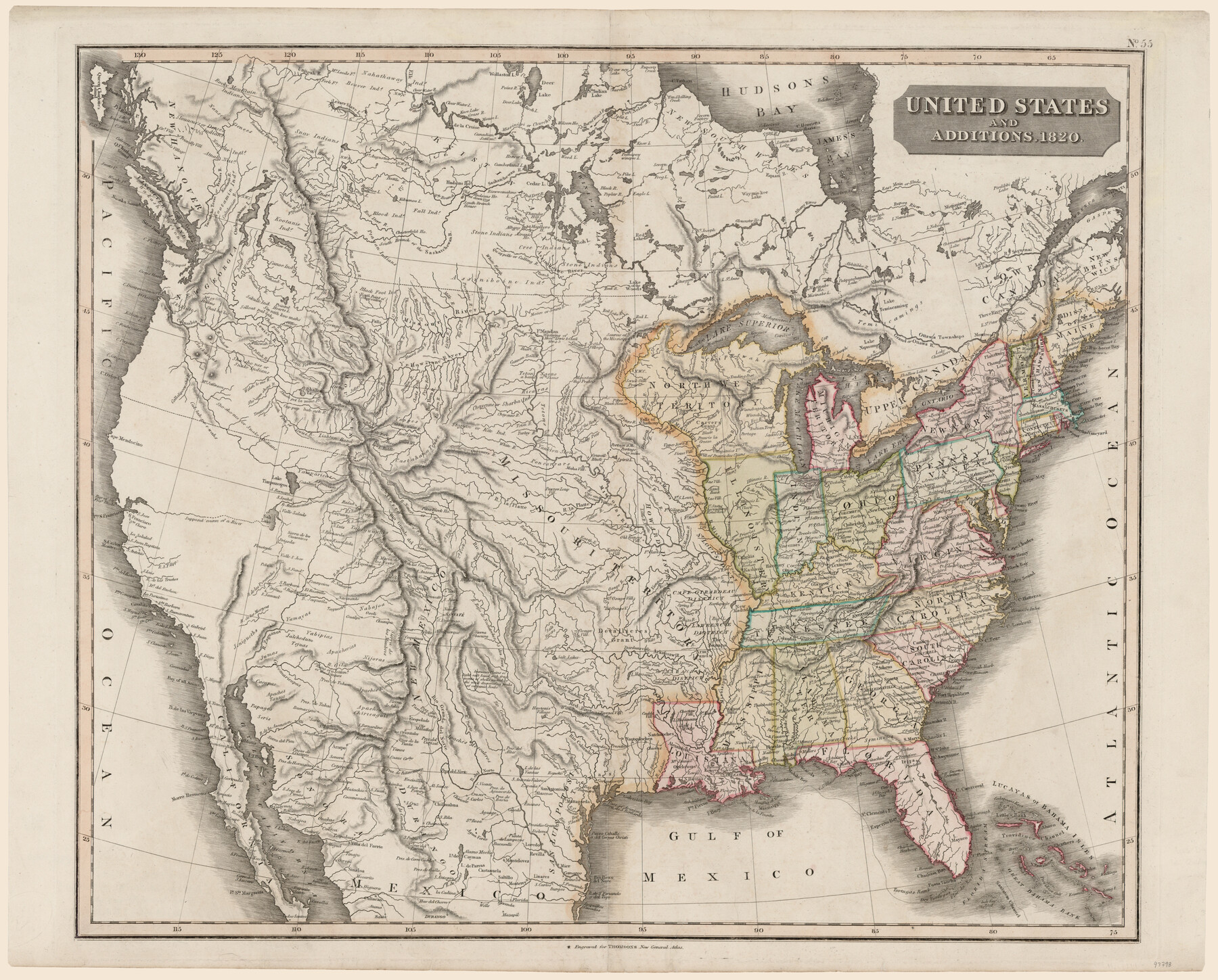
United States and Additions, 1820
-
Map/Doc
93798
-
Collection
General Map Collection
-
Object Dates
1820 (Creation Date)
2015/7/24 (File Date)
-
People and Organizations
[John Thomson] (Author)
-
Subjects
United States
-
Height x Width
21.8 x 27.0 inches
55.4 x 68.6 cm
-
Medium
paper, etching/engraving/lithograph
-
Comments
Map from "Thomson's New General Atlas"
Part of: General Map Collection
San Antonio & Surrounding Area

San Antonio & Surrounding Area
1997
Size 36.4 x 46.3 inches
Map/Doc 96867
Grant of Miguel Rabago

Print $2.00
- Digital $50.00
Grant of Miguel Rabago
Size 8.6 x 8.4 inches
Map/Doc 76047

[Beaumont, Sour Lake and Western Ry. Right of Way and Alignment - Frisco]
![64131, [Beaumont, Sour Lake and Western Ry. Right of Way and Alignment - Frisco], General Map Collection](https://historictexasmaps.com/wmedia_w700/maps/64131.tif.jpg)
Print $20.00
- Digital $50.00
[Beaumont, Sour Lake and Western Ry. Right of Way and Alignment - Frisco]
1910
Size 20.3 x 46.2 inches
Map/Doc 64131
El Paso County Working Sketch 56

Print $40.00
- Digital $50.00
El Paso County Working Sketch 56
1971
Size 65.7 x 43.4 inches
Map/Doc 69078
Navigation Maps of Gulf Intracoastal Waterway, Port Arthur to Brownsville, Texas

Print $4.00
- Digital $50.00
Navigation Maps of Gulf Intracoastal Waterway, Port Arthur to Brownsville, Texas
1951
Size 16.7 x 21.3 inches
Map/Doc 65444
Midland County Working Sketch 33

Print $20.00
- Digital $50.00
Midland County Working Sketch 33
1982
Size 38.2 x 36.2 inches
Map/Doc 71014
Ward County Rolled Sketch 7

Print $40.00
- Digital $50.00
Ward County Rolled Sketch 7
1907
Size 33.9 x 91.0 inches
Map/Doc 10103
Gregg County Sketch File 6

Print $10.00
- Digital $50.00
Gregg County Sketch File 6
1931
Size 11.2 x 8.8 inches
Map/Doc 24577
Wharton County Rolled Sketch 12

Print $20.00
- Digital $50.00
Wharton County Rolled Sketch 12
1986
Size 31.1 x 23.7 inches
Map/Doc 8237
Flight Mission No. DCL-4C, Frame 66, Kenedy County

Print $20.00
- Digital $50.00
Flight Mission No. DCL-4C, Frame 66, Kenedy County
1943
Size 18.6 x 22.3 inches
Map/Doc 85811
Karnes County Sketch File 7a

Print $4.00
- Digital $50.00
Karnes County Sketch File 7a
1873
Size 10.1 x 8.1 inches
Map/Doc 28563
You may also like
Encinal County

Print $20.00
- Digital $50.00
Encinal County
1886
Size 32.7 x 22.4 inches
Map/Doc 3515
Jackson County Working Sketch 6

Print $20.00
- Digital $50.00
Jackson County Working Sketch 6
1971
Size 17.0 x 21.7 inches
Map/Doc 66454
Traveller's Map of the State of Texas

Print $20.00
- Digital $50.00
Traveller's Map of the State of Texas
1867
Size 43.4 x 41.6 inches
Map/Doc 93906
Hardin County Working Sketch 26

Print $20.00
- Digital $50.00
Hardin County Working Sketch 26
1954
Size 19.5 x 23.8 inches
Map/Doc 63424
[Galveston, Harrisburg & San Antonio from El Paso-Presidio county boundary to Presidio-Pecos county boundary]
![64716, [Galveston, Harrisburg & San Antonio from El Paso-Presidio county boundary to Presidio-Pecos county boundary], General Map Collection](https://historictexasmaps.com/wmedia_w700/maps/64716.tif.jpg)
Print $40.00
- Digital $50.00
[Galveston, Harrisburg & San Antonio from El Paso-Presidio county boundary to Presidio-Pecos county boundary]
Size 124.4 x 45.3 inches
Map/Doc 64716
Marion County Working Sketch 5

Print $20.00
- Digital $50.00
Marion County Working Sketch 5
1910
Size 24.5 x 15.2 inches
Map/Doc 70780
Travis County Sketch File 4A

Print $8.00
- Digital $50.00
Travis County Sketch File 4A
1855
Size 8.4 x 11.2 inches
Map/Doc 38280
Padre Island National Seashore, Texas - Dependent Resurvey

Print $4.00
- Digital $50.00
Padre Island National Seashore, Texas - Dependent Resurvey
2001
Size 18.2 x 24.3 inches
Map/Doc 60548
Flight Mission No. DQO-8K, Frame 142, Galveston County

Print $20.00
- Digital $50.00
Flight Mission No. DQO-8K, Frame 142, Galveston County
1952
Size 18.6 x 22.3 inches
Map/Doc 85204
[Sketch for Mineral Application 18874 - Pecos River Bed, W. J. Bonner]
![65583, [Sketch for Mineral Application 18874 - Pecos River Bed, W. J. Bonner], General Map Collection](https://historictexasmaps.com/wmedia_w700/maps/65583.tif.jpg)
Print $20.00
- Digital $50.00
[Sketch for Mineral Application 18874 - Pecos River Bed, W. J. Bonner]
1927
Size 37.6 x 32.3 inches
Map/Doc 65583
Atascosa County Working Sketch 7

Print $3.00
- Digital $50.00
Atascosa County Working Sketch 7
1913
Size 14.0 x 9.4 inches
Map/Doc 67203
Limestone County Sketch File 25

Print $20.00
- Digital $50.00
Limestone County Sketch File 25
Size 25.1 x 32.8 inches
Map/Doc 12003