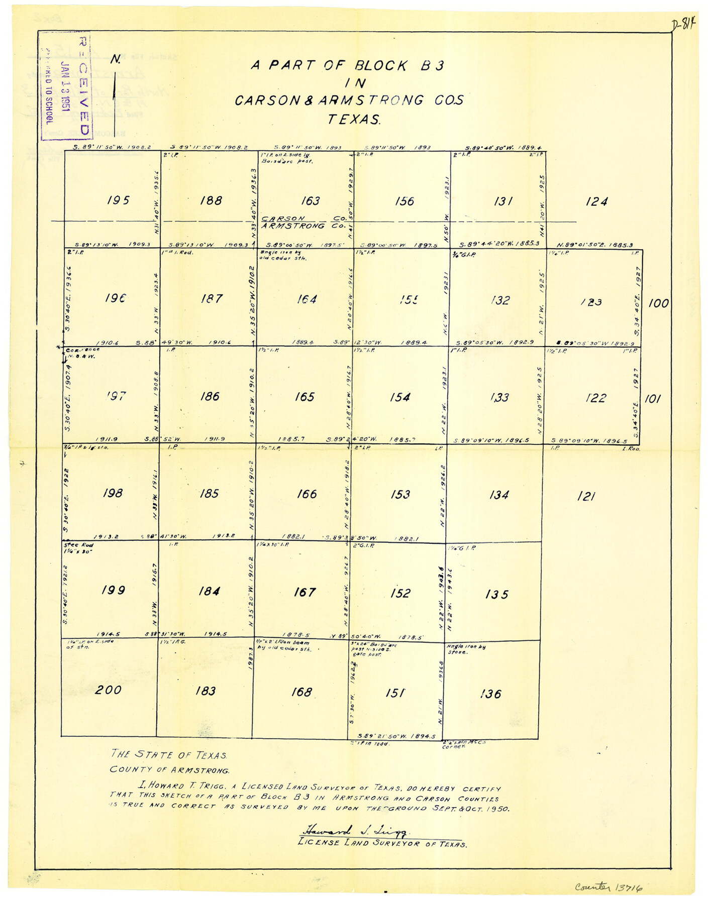
Armstrong County Sketch File A-15
A part of Block B3 in Carson and Armstrong Counties, Texas
-
Map/Doc
13716
-
Collection
General Map Collection
-
Object Dates
1950 (Survey Date)
1951/2/1 (File Date)
1950 (Survey Date)
-
People and Organizations
Howard T. Trigg (Surveyor/Engineer)
-
Counties
Armstrong Carson
-
Subjects
Surveying Sketch File
-
Height x Width
17.8 x 14.0 inches
45.2 x 35.6 cm
-
Medium
blueprint/diazo
Part of: General Map Collection
Terrell County Sketch File 18

Print $8.00
- Digital $50.00
Terrell County Sketch File 18
1908
Size 9.1 x 4.4 inches
Map/Doc 37941
[Sketch for Mineral Application 15559 - Hutchinson County, Canadian River]
![65680, [Sketch for Mineral Application 15559 - Hutchinson County, Canadian River], General Map Collection](https://historictexasmaps.com/wmedia_w700/maps/65680-1.tif.jpg)
Print $20.00
- Digital $50.00
[Sketch for Mineral Application 15559 - Hutchinson County, Canadian River]
1926
Size 12.0 x 13.2 inches
Map/Doc 65680
Flight Mission No. DQN-6K, Frame 8, Calhoun County

Print $20.00
- Digital $50.00
Flight Mission No. DQN-6K, Frame 8, Calhoun County
1953
Size 18.5 x 22.1 inches
Map/Doc 84430
Coke County Rolled Sketch 18

Print $20.00
- Digital $50.00
Coke County Rolled Sketch 18
Size 43.4 x 34.4 inches
Map/Doc 8632
[Surveys along the Little River]
![76048, [Surveys along the Little River], General Map Collection](https://historictexasmaps.com/wmedia_w700/maps/76048.tif.jpg)
Print $2.00
- Digital $50.00
[Surveys along the Little River]
1846
Size 10.6 x 7.8 inches
Map/Doc 76048
Angelina County Working Sketch 34

Print $20.00
- Digital $50.00
Angelina County Working Sketch 34
1956
Size 30.2 x 22.9 inches
Map/Doc 67117
Flight Mission No. CRC-2R, Frame 111, Chambers County

Print $20.00
- Digital $50.00
Flight Mission No. CRC-2R, Frame 111, Chambers County
1956
Size 18.4 x 22.3 inches
Map/Doc 84738
Newton County Sketch File 19

Print $20.00
- Digital $50.00
Newton County Sketch File 19
Size 22.8 x 9.4 inches
Map/Doc 42158
Upshur County Sketch File 21

Print $78.00
- Digital $50.00
Upshur County Sketch File 21
2000
Size 36.6 x 24.9 inches
Map/Doc 12508
Harris County Historic Topographic 22

Print $20.00
- Digital $50.00
Harris County Historic Topographic 22
1915
Size 29.2 x 22.7 inches
Map/Doc 65833
Pecos County Sketch File 22

Print $20.00
- Digital $50.00
Pecos County Sketch File 22
1886
Size 14.0 x 8.8 inches
Map/Doc 33670
Lamar County Working Sketch 7

Print $20.00
- Digital $50.00
Lamar County Working Sketch 7
1964
Size 18.7 x 17.6 inches
Map/Doc 70268
You may also like
Donley County Boundary File 4

Print $10.00
- Digital $50.00
Donley County Boundary File 4
Size 5.7 x 8.4 inches
Map/Doc 52630
Dimmit County Sketch File 2

Print $6.00
- Digital $50.00
Dimmit County Sketch File 2
Size 8.6 x 7.9 inches
Map/Doc 21055
Brown County Working Sketch 19

Print $20.00
- Digital $50.00
Brown County Working Sketch 19
1998
Size 37.1 x 34.8 inches
Map/Doc 67784
Zavala County Sketch File 46

Print $20.00
- Digital $50.00
Zavala County Sketch File 46
1937
Size 16.7 x 18.8 inches
Map/Doc 12734

Working Sketch of Moore County

Print $20.00
- Digital $50.00
Working Sketch of Moore County
Size 27.7 x 15.6 inches
Map/Doc 93002
Henderson County Sketch File 7

Print $4.00
- Digital $50.00
Henderson County Sketch File 7
1854
Size 8.6 x 8.6 inches
Map/Doc 26329
Tyler County Sketch File 25

Print $28.00
- Digital $50.00
Tyler County Sketch File 25
1953
Size 14.5 x 9.0 inches
Map/Doc 38689
Tom Green County Boundary File 6

Print $42.00
- Digital $50.00
Tom Green County Boundary File 6
Size 14.5 x 9.0 inches
Map/Doc 59376
Flight Mission No. BRE-2P, Frame 62, Nueces County

Print $20.00
- Digital $50.00
Flight Mission No. BRE-2P, Frame 62, Nueces County
1956
Size 18.3 x 22.5 inches
Map/Doc 86757
Flight Mission No. CGI-3N, Frame 179, Cameron County

Print $20.00
- Digital $50.00
Flight Mission No. CGI-3N, Frame 179, Cameron County
1954
Size 18.6 x 22.2 inches
Map/Doc 84643
Williamson County Sketch File 20

Print $4.00
- Digital $50.00
Williamson County Sketch File 20
Size 8.2 x 12.9 inches
Map/Doc 40348