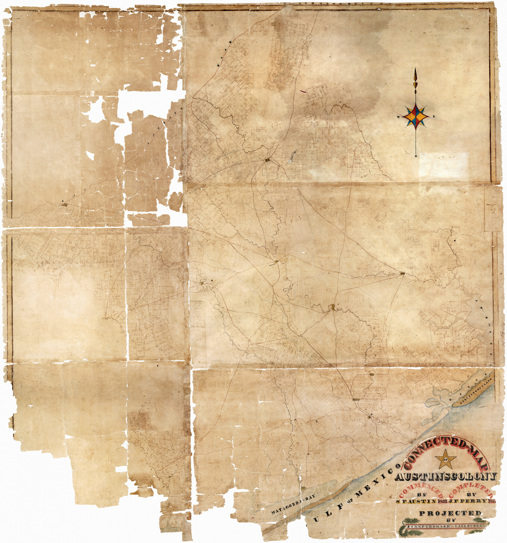
Connected Map of Austin's Colony
T-1-3
-
Map/Doc
1943
-
Collection
General Map Collection
-
Object Dates
1837 (Creation Date)
-
People and Organizations
Stephen F. Austin (Author)
James Franklin Perry (Author)
John P. Borden (Surveyor/Engineer)
Gail Borden (Surveyor/Engineer)
Thomas Borden (Surveyor/Engineer)
-
Subjects
Colony
-
Height x Width
90.6 x 80.9 inches
230.1 x 205.5 cm
-
Medium
paper, manuscript
-
Comments
Commenced 1833 by S. F. Austin, Completed 1837 by J. F. Perry. See 93376 for east part of map, and 93377 for west part of map.
Conservation funded in 2002 with donation from Gardere Wynne Sewell LLP.
Digitized in 2012 with a generous donation from the Texas Society, Daughters of the American Revolution.
Reproductions are printed at 62.6" x 59.1" (69% of actual size) -
URLs
https://medium.com/save-texas-history/the-connected-map-of-austins-colony-1837-66cdc0c4dfa4
Related maps
Connected Map of Austin's Colony

Print $40.00
- Digital $50.00
Connected Map of Austin's Colony
1837
Size 90.8 x 85.6 inches
Map/Doc 1944
Harris County Rolled Sketch 33

Print $20.00
- Digital $50.00
Harris County Rolled Sketch 33
1912
Size 26.0 x 34.5 inches
Map/Doc 6097
Connected Map of Austin's Colony (1892 tracing)

Print $40.00
- Digital $50.00
Connected Map of Austin's Colony (1892 tracing)
1837
Size 90.8 x 46.7 inches
Map/Doc 93358
Connected Map of Austin's Colony (1892 tracing)

Print $40.00
- Digital $50.00
Connected Map of Austin's Colony (1892 tracing)
1837
Size 90.8 x 46.5 inches
Map/Doc 93359
Connected Map of Austin's Colony

Print $40.00
- Digital $50.00
Connected Map of Austin's Colony
1837
Size 93.2 x 43.1 inches
Map/Doc 93376
Connected Map of Austin's Colony

Print $40.00
- Digital $50.00
Connected Map of Austin's Colony
1837
Size 93.2 x 43.7 inches
Map/Doc 93377
The Compass Rose of Austin's Colony

Price $20.00
The Compass Rose of Austin's Colony
2016
Size 4.0 x 3.5 inches
Map/Doc 94443
Part of: General Map Collection
Leon County Working Sketch 14

Print $40.00
- Digital $50.00
Leon County Working Sketch 14
1956
Size 48.8 x 34.5 inches
Map/Doc 70413
[Right of Way & Track Map, The Texas & Pacific Ry. Co. Main Line]
![64682, [Right of Way & Track Map, The Texas & Pacific Ry. Co. Main Line], General Map Collection](https://historictexasmaps.com/wmedia_w700/maps/64682.tif.jpg)
Print $20.00
- Digital $50.00
[Right of Way & Track Map, The Texas & Pacific Ry. Co. Main Line]
Size 11.4 x 18.4 inches
Map/Doc 64682
Wise County Sketch File 12

Print $20.00
- Digital $50.00
Wise County Sketch File 12
1854
Size 13.4 x 19.0 inches
Map/Doc 12699
Medina County Working Sketch 2

Print $20.00
- Digital $50.00
Medina County Working Sketch 2
1942
Size 30.3 x 31.0 inches
Map/Doc 70917
Primera parte del Mapa, que comprende la Frontera, de los Dominios del Rey, en la America Septentrional

Print $40.00
- Digital $50.00
Primera parte del Mapa, que comprende la Frontera, de los Dominios del Rey, en la America Septentrional
1769
Size 25.8 x 63.2 inches
Map/Doc 3062
Presidio County Sketch File 67

Print $6.00
- Digital $50.00
Presidio County Sketch File 67
1940
Size 11.3 x 8.9 inches
Map/Doc 34659
Flight Mission No. CRC-3R, Frame 42, Chambers County

Print $20.00
- Digital $50.00
Flight Mission No. CRC-3R, Frame 42, Chambers County
1956
Size 18.8 x 22.4 inches
Map/Doc 84815
Flight Mission No. DAG-23K, Frame 169, Matagorda County

Print $20.00
- Digital $50.00
Flight Mission No. DAG-23K, Frame 169, Matagorda County
1953
Size 16.0 x 15.8 inches
Map/Doc 86507
Trinity River, Owen Crossing Sheet/Elm Fork of Trinity River

Print $20.00
- Digital $50.00
Trinity River, Owen Crossing Sheet/Elm Fork of Trinity River
1914
Size 29.1 x 31.4 inches
Map/Doc 65201
Trinity River, Slate Rock Ferry Sheet/East Fork of Trinity River

Print $6.00
- Digital $50.00
Trinity River, Slate Rock Ferry Sheet/East Fork of Trinity River
1922
Size 35.1 x 34.3 inches
Map/Doc 65185
Hidalgo County Rolled Sketch 15

Print $40.00
- Digital $50.00
Hidalgo County Rolled Sketch 15
1963
Size 68.9 x 41.9 inches
Map/Doc 9170
Shackelford County Sketch File 17

Print $4.00
Shackelford County Sketch File 17
2009
Size 14.0 x 8.5 inches
Map/Doc 89230
You may also like

Young County Rolled Sketch 16

Print $20.00
- Digital $50.00
Young County Rolled Sketch 16
1982
Size 19.1 x 31.3 inches
Map/Doc 8304
Flight Mission No. BRA-9M, Frame 60, Jefferson County

Print $20.00
- Digital $50.00
Flight Mission No. BRA-9M, Frame 60, Jefferson County
1953
Size 18.6 x 22.4 inches
Map/Doc 85643
[Gunter & Munson, Maddox Bros. & Anderson Blocks F and A and State University Lands Blocks 15-17 and 50]
![91847, [Gunter & Munson, Maddox Bros. & Anderson Blocks F and A and State University Lands Blocks 15-17 and 50], Twichell Survey Records](https://historictexasmaps.com/wmedia_w700/maps/91847-1.tif.jpg)
Print $20.00
- Digital $50.00
[Gunter & Munson, Maddox Bros. & Anderson Blocks F and A and State University Lands Blocks 15-17 and 50]
1884
Size 12.2 x 16.2 inches
Map/Doc 91847
Angelina County Sketch File 14

Print $2.00
- Digital $50.00
Angelina County Sketch File 14
Size 7.6 x 6.9 inches
Map/Doc 12959
Brewster County Sketch File NS-2

Print $14.00
- Digital $50.00
Brewster County Sketch File NS-2
1913
Size 14.3 x 8.8 inches
Map/Doc 15946
Map of the Interior of Louisiana with a part of New Mexico

Print $20.00
Map of the Interior of Louisiana with a part of New Mexico
1811
Size 11.1 x 14.2 inches
Map/Doc 94269
Aransas County Sketch File 8

Print $4.00
- Digital $50.00
Aransas County Sketch File 8
Size 11.7 x 7.9 inches
Map/Doc 13114

Baylor County Sketch File 12B

Print $6.00
- Digital $50.00
Baylor County Sketch File 12B
1900
Size 13.4 x 9.0 inches
Map/Doc 14152
Armstrong County Working Sketch 11

Print $20.00
- Digital $50.00
Armstrong County Working Sketch 11
2025
Map/Doc 97507
[Capitol Leagues 633, 634, 635, 636, and 637]
![90998, [Capitol Leagues 633, 634, 635, 636, and 637], Twichell Survey Records](https://historictexasmaps.com/wmedia_w700/maps/90998-1.tif.jpg)
Print $20.00
- Digital $50.00
[Capitol Leagues 633, 634, 635, 636, and 637]
Size 23.2 x 10.2 inches
Map/Doc 90998