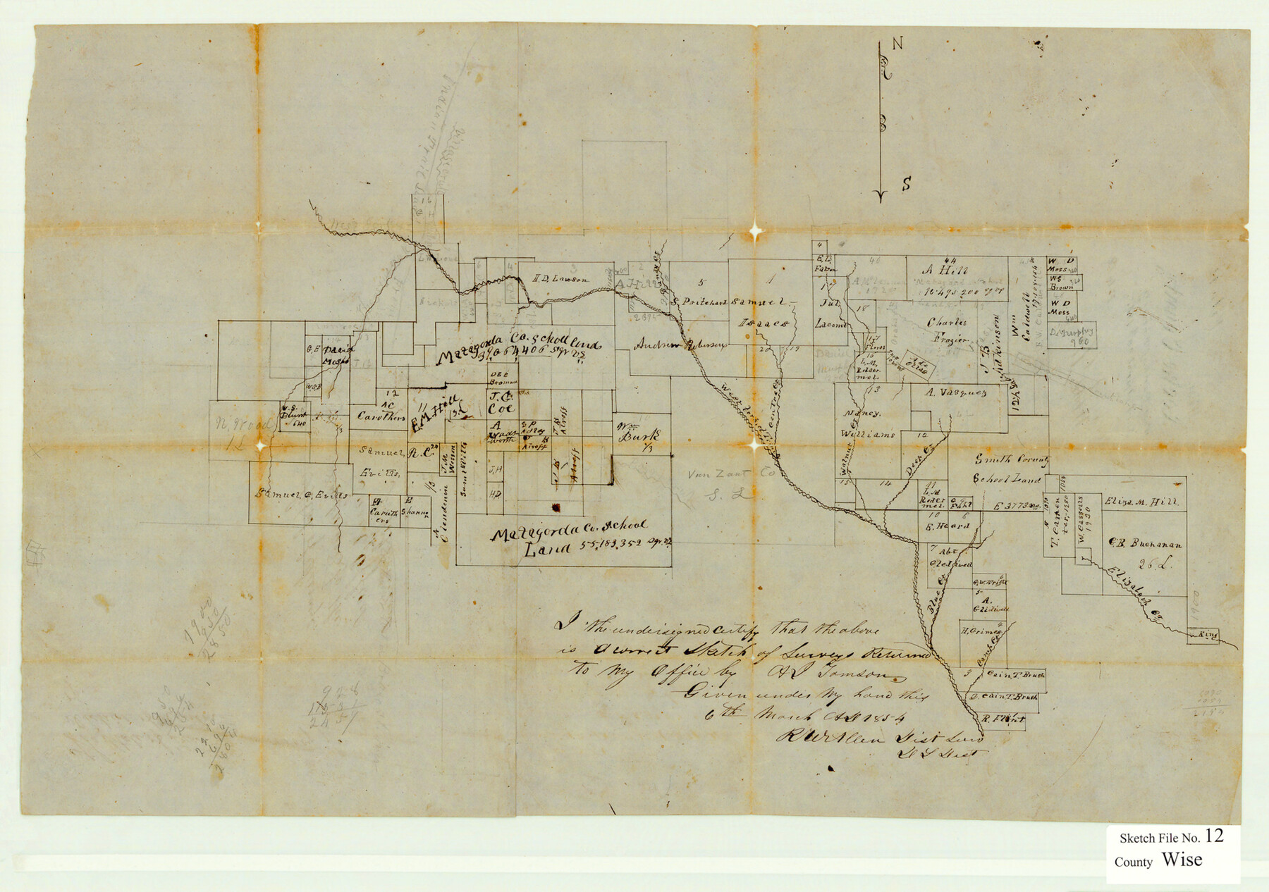
Wise County Sketch File 12
[Sketch of surveys in the southwest part of the county near the West Fork of the Trinity River]
-
Map/Doc
12699
-
Collection
General Map Collection
-
Object Dates
3/6/1854 (Creation Date)
-
People and Organizations
R.W. Allen (Surveyor/Engineer)
-
Counties
Wise
-
Subjects
Surveying Sketch File
-
Height x Width
13.4 x 19.0 inches
34.0 x 48.3 cm
-
Medium
paper, manuscript
-
Features
Indian Trail
Village Creek
Sandy Creek
Thomson Creek
West Fork of Trinity River
Centre Creek
Walnut Creek
Deep Creek
Elizabeth Creek
Blue Creek
Camp Creek
Part of: General Map Collection
Harrison County Sketch File 21

Print $20.00
- Digital $50.00
Harrison County Sketch File 21
1892
Size 20.2 x 25.7 inches
Map/Doc 11694
Lee County Working Sketch 16

Print $20.00
- Digital $50.00
Lee County Working Sketch 16
1982
Size 20.5 x 13.5 inches
Map/Doc 70395
Martin County Sketch File 3

Print $19.00
- Digital $50.00
Martin County Sketch File 3
Size 7.4 x 8.6 inches
Map/Doc 30632
Descripcion del Destricto del Audiencia de la Nueva Galicia

Print $20.00
- Digital $50.00
Descripcion del Destricto del Audiencia de la Nueva Galicia
1622
Size 13.0 x 17.6 inches
Map/Doc 97258
Flight Mission No. BRA-16M, Frame 130, Jefferson County

Print $20.00
- Digital $50.00
Flight Mission No. BRA-16M, Frame 130, Jefferson County
1953
Size 18.5 x 22.5 inches
Map/Doc 85740
Motley County Sketch File 8 (N)

Print $6.00
- Digital $50.00
Motley County Sketch File 8 (N)
1901
Size 13.2 x 8.1 inches
Map/Doc 32016
Newton County

Print $40.00
- Digital $50.00
Newton County
1946
Size 48.7 x 41.9 inches
Map/Doc 66953
Pecos County Working Sketch 67

Print $20.00
- Digital $50.00
Pecos County Working Sketch 67
1955
Size 17.7 x 18.7 inches
Map/Doc 71539
Gaines County Rolled Sketch 12

Print $20.00
- Digital $50.00
Gaines County Rolled Sketch 12
1940
Size 26.4 x 33.5 inches
Map/Doc 5933
San Saba County Sketch File 13

Print $20.00
- Digital $50.00
San Saba County Sketch File 13
1890
Size 20.9 x 19.2 inches
Map/Doc 12291
Flight Mission No. CRK-7P, Frame 80, Refugio County

Print $20.00
- Digital $50.00
Flight Mission No. CRK-7P, Frame 80, Refugio County
1956
Size 18.4 x 22.2 inches
Map/Doc 86951
Trinity River, Hughes Crossing Sheet/Chambers Creek

Print $6.00
- Digital $50.00
Trinity River, Hughes Crossing Sheet/Chambers Creek
1931
Size 32.5 x 30.2 inches
Map/Doc 65239
You may also like
Smith County Rolled Sketch 6E1

Print $20.00
- Digital $50.00
Smith County Rolled Sketch 6E1
1966
Size 27.4 x 22.7 inches
Map/Doc 10612
Gaines County Boundary File 4

Print $4.00
- Digital $50.00
Gaines County Boundary File 4
Size 14.4 x 8.9 inches
Map/Doc 53656
Briscoe County Boundary File 1

Print $90.00
- Digital $50.00
Briscoe County Boundary File 1
Size 8.6 x 6.8 inches
Map/Doc 50758
Flight Mission No. BRE-1P, Frame 51, Nueces County

Print $20.00
- Digital $50.00
Flight Mission No. BRE-1P, Frame 51, Nueces County
1956
Size 18.3 x 22.2 inches
Map/Doc 86640
Navigation Maps of Gulf Intracoastal Waterway, Port Arthur to Brownsville, Texas

Print $4.00
- Digital $50.00
Navigation Maps of Gulf Intracoastal Waterway, Port Arthur to Brownsville, Texas
1951
Size 16.7 x 21.6 inches
Map/Doc 65447
Lampasas County Boundary File 16

Print $14.00
- Digital $50.00
Lampasas County Boundary File 16
Size 8.9 x 8.2 inches
Map/Doc 56216
Lampasas County Working Sketch 13

Print $20.00
- Digital $50.00
Lampasas County Working Sketch 13
1973
Size 34.4 x 27.7 inches
Map/Doc 70290
Wichita County Working Sketch 26

Print $20.00
- Digital $50.00
Wichita County Working Sketch 26
1981
Size 13.1 x 21.0 inches
Map/Doc 72536
Real County Working Sketch 47

Print $20.00
- Digital $50.00
Real County Working Sketch 47
1956
Size 15.9 x 12.9 inches
Map/Doc 97488
Brazoria County Sketch File 39

Print $8.00
- Digital $50.00
Brazoria County Sketch File 39
1933
Size 11.3 x 8.8 inches
Map/Doc 15045
Flight Mission No. CGI-3N, Frame 107, Cameron County

Print $20.00
- Digital $50.00
Flight Mission No. CGI-3N, Frame 107, Cameron County
1954
Size 18.6 x 22.3 inches
Map/Doc 84587
Jackson County Sketch File 25

Print $20.00
- Digital $50.00
Jackson County Sketch File 25
1942
Size 15.4 x 37.4 inches
Map/Doc 11845