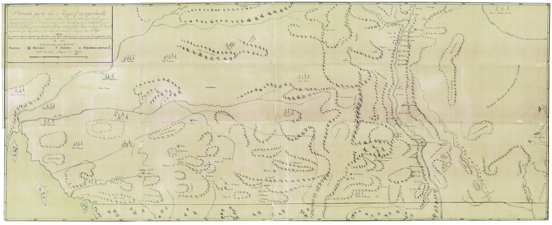
Primera parte del Mapa, que comprende la Frontera, de los Dominios del Rey, en la America Septentrional
[Translation: First part of a Map of the frontier of the King's Domain in North America]
A-7-28
-
Map/Doc
3062
-
Collection
General Map Collection
-
Object Dates
1769 (Creation Date)
-
People and Organizations
Luis de Surville (Draftsman)
Nicolas LaFora (Compiler)
Joseph de Urrutia (Compiler)
Joseph de Urrutia (Draftsman)
-
Subjects
Spanish Texas
-
Height x Width
25.8 x 63.2 inches
65.5 x 160.5 cm
-
Comments
Copied by Luis de Surville according to original made by Joseph de Urrutia on various points observed by him and the Captain of Engineering, Nicolas LaFora and the most true diaries.
For second half of map see 4667.
Related maps
Segunda parte del Mapa, que comprende la Frontera, de los Dominios del Rey, en la America Septentrional

Print $40.00
- Digital $50.00
Segunda parte del Mapa, que comprende la Frontera, de los Dominios del Rey, en la America Septentrional
1769
Size 26.7 x 63.8 inches
Map/Doc 4667
Mapa de toda la Frontera de los dominios del Rey en la America septentrional

Print $40.00
Mapa de toda la Frontera de los dominios del Rey en la America septentrional
1771
Size 26.4 x 50.0 inches
Map/Doc 95311
Mapa que comprende la Frontera de los Dominios del Rey, en la America Septentrional, segun el original que hizo D. Joseph de Urrutia, sobre varios puntos observados por él, y el Capitan de Yngenieros D. Nicolas Lafora

Print $40.00
Mapa que comprende la Frontera de los Dominios del Rey, en la America Septentrional, segun el original que hizo D. Joseph de Urrutia, sobre varios puntos observados por él, y el Capitan de Yngenieros D. Nicolas Lafora
1769
Size 50.9 x 128.2 inches
Map/Doc 95711
Plano del Presidio de Nra. Senora del Pilar de los Adaes, Capital de la Provincia de los Tejas situado en 32 grados y 15 minutos de Latitud Boreal, y en 285° y 52' de Longitud respecto del Meridiano de Tenerife

Plano del Presidio de Nra. Senora del Pilar de los Adaes, Capital de la Provincia de los Tejas situado en 32 grados y 15 minutos de Latitud Boreal, y en 285° y 52' de Longitud respecto del Meridiano de Tenerife
Size 16.9 x 21.4 inches
Map/Doc 96563
Plano de la Villa y Presidio de S. Antonio de Vejar situado en la Provincia de Tejas en 29 grad. y 52 minutos de latitud bor. y 275° y 57' de long. contados desde de Meridiano d. Tenerife

Plano de la Villa y Presidio de S. Antonio de Vejar situado en la Provincia de Tejas en 29 grad. y 52 minutos de latitud bor. y 275° y 57' de long. contados desde de Meridiano d. Tenerife
1768
Size 16.8 x 21.2 inches
Map/Doc 96564
Plano del Presidio de Bahia dela Espiritu Santo dependite dela Governacion de los Tejas situado en 29 grad. Y 39 min. de latitud boreal y 277° y 54' dela long. contados desde el Merid. De Tenerife

Plano del Presidio de Bahia dela Espiritu Santo dependite dela Governacion de los Tejas situado en 29 grad. Y 39 min. de latitud boreal y 277° y 54' dela long. contados desde el Merid. De Tenerife
1768
Size 16.7 x 21.0 inches
Map/Doc 96565
Part of: General Map Collection
Flight Mission No. DQN-2K, Frame 46, Calhoun County

Print $20.00
- Digital $50.00
Flight Mission No. DQN-2K, Frame 46, Calhoun County
1953
Size 18.5 x 22.1 inches
Map/Doc 84251
Old Miscellaneous File 19

Print $32.00
- Digital $50.00
Old Miscellaneous File 19
Size 14.2 x 8.8 inches
Map/Doc 75499
Hemphill County Working Sketch 26

Print $40.00
- Digital $50.00
Hemphill County Working Sketch 26
1974
Size 57.2 x 48.3 inches
Map/Doc 66121
Brewster County Working Sketch 117

Print $20.00
- Digital $50.00
Brewster County Working Sketch 117
1988
Size 33.3 x 37.0 inches
Map/Doc 67717
Galveston County NRC Article 33.136 Sketch 82

Print $82.00
- Digital $50.00
Galveston County NRC Article 33.136 Sketch 82
2015
Size 24.0 x 36.0 inches
Map/Doc 94601
Terry County Sketch File 16

Print $20.00
- Digital $50.00
Terry County Sketch File 16
1945
Size 39.9 x 25.4 inches
Map/Doc 10399
Limestone County Sketch File B

Print $8.00
- Digital $50.00
Limestone County Sketch File B
1878
Size 8.2 x 7.3 inches
Map/Doc 30151
Map of Jones County West of the Clearfork of the Brazos River Young - East of it Milam - Land District

Print $20.00
- Digital $50.00
Map of Jones County West of the Clearfork of the Brazos River Young - East of it Milam - Land District
1859
Size 22.0 x 26.5 inches
Map/Doc 3741
Brazoria County Working Sketch 35

Print $40.00
- Digital $50.00
Brazoria County Working Sketch 35
1981
Size 43.5 x 66.2 inches
Map/Doc 67520
Chambers County NRC Article 33.136 Sketch 12

Print $30.00
- Digital $50.00
Chambers County NRC Article 33.136 Sketch 12
2020
Size 24.0 x 35.9 inches
Map/Doc 96441
Lynn County Sketch File 2

Print $5.00
- Digital $50.00
Lynn County Sketch File 2
1902
Size 11.6 x 17.1 inches
Map/Doc 30447
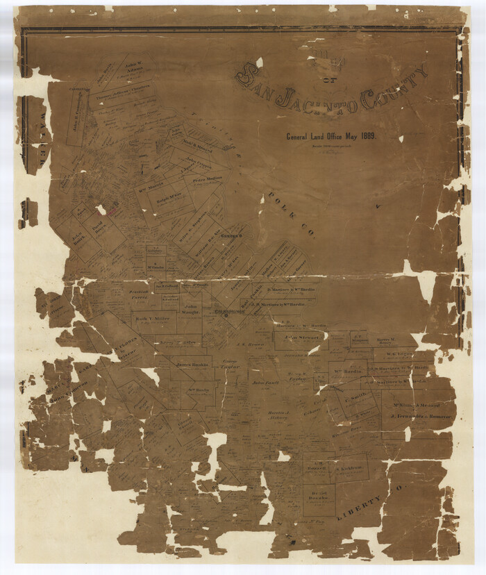
Map of San Jacinto County
Print $20.00
- Digital $50.00
Map of San Jacinto County
1889
Size 43.8 x 37.0 inches
Map/Doc 16808
You may also like
[Map of Block 97, Borden and Scurry Co (Exhibit A); Map of Southeastern part of Young Territory; Map of part of of Borden, Fisher, Kent, Mitchell, Scurry and Garza Cos. Showing the north boundary line of the T&P 80 mile reservation]
![65693, [Map of Block 97, Borden and Scurry Co (Exhibit A); Map of Southeastern part of Young Territory; Map of part of of Borden, Fisher, Kent, Mitchell, Scurry and Garza Cos. Showing the north boundary line of the T&P 80 mile reservation], General Map Collection](https://historictexasmaps.com/wmedia_w700/maps/65693.tif.jpg)
Print $20.00
- Digital $50.00
[Map of Block 97, Borden and Scurry Co (Exhibit A); Map of Southeastern part of Young Territory; Map of part of of Borden, Fisher, Kent, Mitchell, Scurry and Garza Cos. Showing the north boundary line of the T&P 80 mile reservation]
1901
Size 31.2 x 23.3 inches
Map/Doc 65693
Flight Mission No. DQN-1K, Frame 33, Calhoun County

Print $20.00
- Digital $50.00
Flight Mission No. DQN-1K, Frame 33, Calhoun County
1953
Size 15.5 x 15.5 inches
Map/Doc 84138
Along the Sunset Route, Southern Pacific Lines - Texas and Louisiana

Along the Sunset Route, Southern Pacific Lines - Texas and Louisiana
1947
Map/Doc 96720
[Plat showing connecting lines for the purpose of locating 4.3 acres in Caldwell County]
![90221, [Plat showing connecting lines for the purpose of locating 4.3 acres in Caldwell County], Twichell Survey Records](https://historictexasmaps.com/wmedia_w700/maps/90221-1.tif.jpg)
Print $2.00
- Digital $50.00
[Plat showing connecting lines for the purpose of locating 4.3 acres in Caldwell County]
1923
Size 7.0 x 10.0 inches
Map/Doc 90221
[Worksheets related to the Wilson Strickland survey and vicinity]
![91282, [Worksheets related to the Wilson Strickland survey and vicinity], Twichell Survey Records](https://historictexasmaps.com/wmedia_w700/maps/91282-1.tif.jpg)
Print $20.00
- Digital $50.00
[Worksheets related to the Wilson Strickland survey and vicinity]
Size 7.9 x 24.3 inches
Map/Doc 91282
Bosque County Working Sketch 21

Print $40.00
- Digital $50.00
Bosque County Working Sketch 21
1984
Size 38.5 x 55.1 inches
Map/Doc 67454
Montgomery County Working Sketch 36

Print $20.00
- Digital $50.00
Montgomery County Working Sketch 36
1953
Size 34.6 x 34.5 inches
Map/Doc 71143
Plat Section 2, Block B-16

Print $20.00
- Digital $50.00
Plat Section 2, Block B-16
1930
Size 19.0 x 9.8 inches
Map/Doc 90802
Upton County Rolled Sketch 10

Print $20.00
- Digital $50.00
Upton County Rolled Sketch 10
1911
Size 41.2 x 43.0 inches
Map/Doc 10035
Renderbrook Ranch

Print $20.00
- Digital $50.00
Renderbrook Ranch
1932
Size 16.9 x 13.5 inches
Map/Doc 92279
Harris County Working Sketch 102

Print $20.00
- Digital $50.00
Harris County Working Sketch 102
1980
Size 33.6 x 18.9 inches
Map/Doc 65994
Coryell County Boundary File 22

Print $60.00
- Digital $50.00
Coryell County Boundary File 22
Size 7.2 x 3.7 inches
Map/Doc 51932