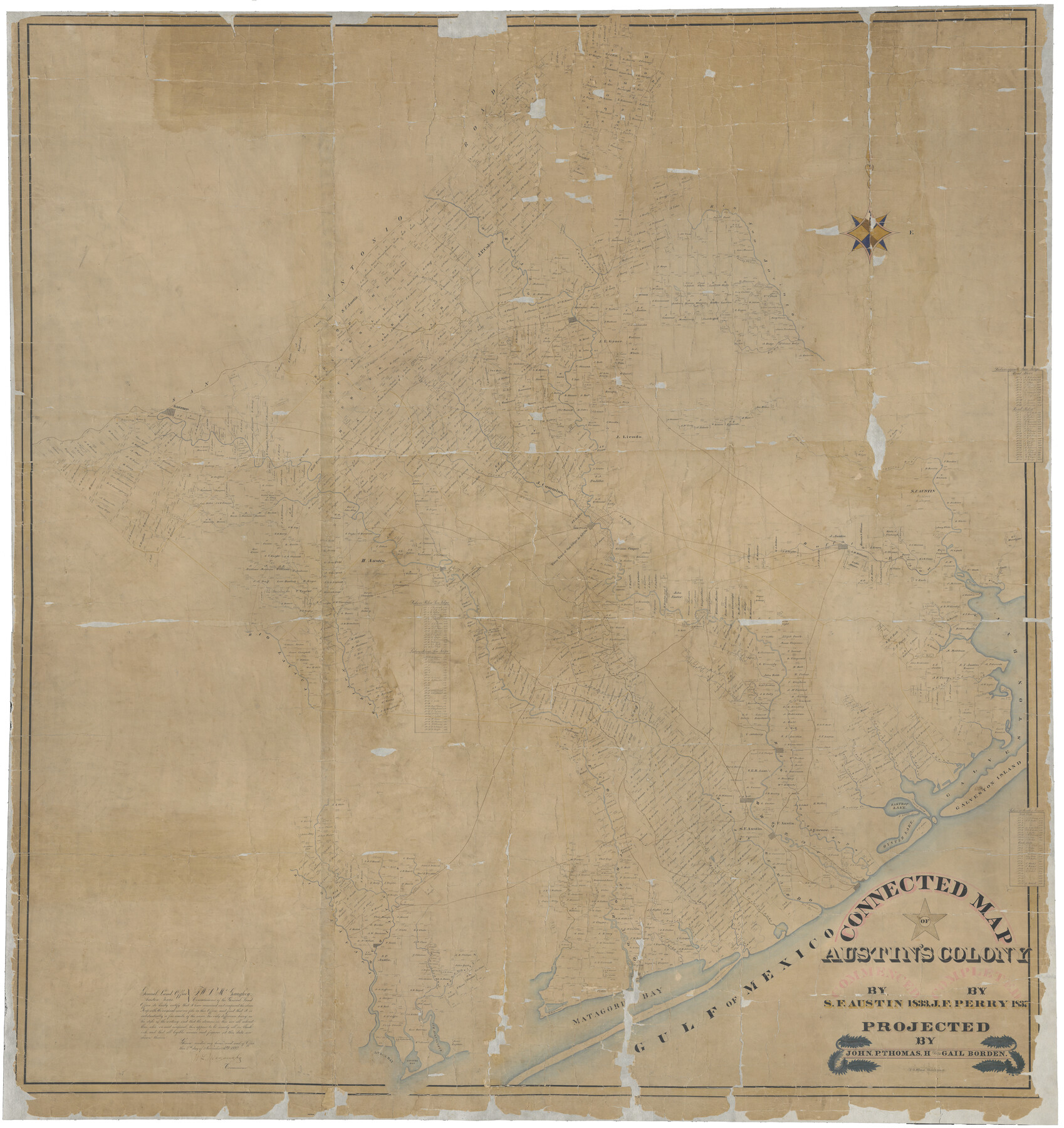
Connected Map of Austin's Colony
T-1-4
1892 certified tracing of 1833-1837 original
-
Map/Doc
1944
-
Collection
General Map Collection
-
Object Dates
1892 (Copy/Tracing Date)
1837 (Creation Date)
-
People and Organizations
Stephen F. Austin (Author)
W.L. McGaughey (GLO Commissioner)
James Franklin Perry (Author)
Thomas Borden (Surveyor/Engineer)
John P. Borden (Surveyor/Engineer)
Gail Borden (Surveyor/Engineer)
F.G. Blau (Draftsman)
-
Subjects
Colony
-
Height x Width
90.8 x 85.6 inches
230.6 x 217.4 cm
-
Medium
paper, manuscript
-
Comments
1892 certified copy of map no. 1943. See 93358 for east part of map and 93359 for west part of map.
Conservation funded in 2002 with donation from Texas Association of Counties.
Digitized in 2012 with a generous donation from the Texas Society, Daughters of the American Revolution.
Reproductions are printed at 62.6" x 59.1" (69% of actual size) -
URLs
https://medium.com/save-texas-history/stephen-f-austins-connected-map-of-austin-s-colony-1837-1892-tracing-56517d0ec260
Related maps
Connected Map of Austin's Colony

Print $40.00
- Digital $50.00
Connected Map of Austin's Colony
1837
Size 90.6 x 80.9 inches
Map/Doc 1943
Connected Map of Austin's Colony (1892 tracing)

Print $40.00
- Digital $50.00
Connected Map of Austin's Colony (1892 tracing)
1837
Size 90.8 x 46.7 inches
Map/Doc 93358
Connected Map of Austin's Colony (1892 tracing)

Print $40.00
- Digital $50.00
Connected Map of Austin's Colony (1892 tracing)
1837
Size 90.8 x 46.5 inches
Map/Doc 93359
The Compass Rose of Austin's Colony

Price $20.00
The Compass Rose of Austin's Colony
2016
Size 4.0 x 3.5 inches
Map/Doc 94443
Part of: General Map Collection
Trinity County Working Sketch 14

Print $20.00
- Digital $50.00
Trinity County Working Sketch 14
1956
Size 24.8 x 29.9 inches
Map/Doc 69463
Maps of Gulf Intracoastal Waterway, Texas - Sabine River to the Rio Grande and connecting waterways including ship channels

Print $20.00
- Digital $50.00
Maps of Gulf Intracoastal Waterway, Texas - Sabine River to the Rio Grande and connecting waterways including ship channels
1966
Size 14.6 x 22.5 inches
Map/Doc 61935
Flight Mission No. BQR-20K, Frame 14, Brazoria County

Print $20.00
- Digital $50.00
Flight Mission No. BQR-20K, Frame 14, Brazoria County
1952
Size 18.6 x 22.3 inches
Map/Doc 84116
Brewster County Working Sketch 8

Print $20.00
- Digital $50.00
Brewster County Working Sketch 8
1910
Size 42.3 x 30.3 inches
Map/Doc 67541
Bowie County Sketch File 7b

Print $10.00
- Digital $50.00
Bowie County Sketch File 7b
1927
Size 10.7 x 8.6 inches
Map/Doc 14859
Ector County Boundary File 3

Print $18.00
- Digital $50.00
Ector County Boundary File 3
Size 9.0 x 4.4 inches
Map/Doc 52836
Robertson County Rolled Sketch 5

Print $20.00
- Digital $50.00
Robertson County Rolled Sketch 5
1976
Size 34.1 x 36.4 inches
Map/Doc 9864
Industrial - Commercial - Progressive Dallas

Industrial - Commercial - Progressive Dallas
1940
Size 19.1 x 23.7 inches
Map/Doc 96509
Atascosa County Sketch File 2a

Print $40.00
- Digital $50.00
Atascosa County Sketch File 2a
Size 25.1 x 15.3 inches
Map/Doc 10858
Potter County Rolled Sketch 6

Print $20.00
- Digital $50.00
Potter County Rolled Sketch 6
Size 26.3 x 35.0 inches
Map/Doc 7320
Flight Mission No. DCL-7C, Frame 30, Kenedy County

Print $20.00
- Digital $50.00
Flight Mission No. DCL-7C, Frame 30, Kenedy County
1943
Size 15.3 x 15.1 inches
Map/Doc 86022
Hardin County Rolled Sketch 20

Print $20.00
- Digital $50.00
Hardin County Rolled Sketch 20
1960
Size 27.7 x 35.9 inches
Map/Doc 6089
You may also like
Runnels County Rolled Sketch 35

Print $20.00
- Digital $50.00
Runnels County Rolled Sketch 35
1950
Size 34.1 x 44.6 inches
Map/Doc 7523

Val Verde County Rolled Sketch 42

Print $20.00
- Digital $50.00
Val Verde County Rolled Sketch 42
1919
Size 17.3 x 21.9 inches
Map/Doc 8116
Jasper County Working Sketch 4

Print $20.00
- Digital $50.00
Jasper County Working Sketch 4
1905
Size 20.3 x 13.5 inches
Map/Doc 66466
Val Verde County Working Sketch 98

Print $20.00
- Digital $50.00
Val Verde County Working Sketch 98
1980
Size 26.5 x 31.8 inches
Map/Doc 72233
Baylor County, Texas

Print $20.00
- Digital $50.00
Baylor County, Texas
1879
Size 22.2 x 17.4 inches
Map/Doc 586
Hall County Sketch File 14

Print $20.00
- Digital $50.00
Hall County Sketch File 14
1882
Size 20.9 x 32.9 inches
Map/Doc 11607
Medina County Working Sketch 9

Print $20.00
- Digital $50.00
Medina County Working Sketch 9
1959
Size 25.3 x 38.8 inches
Map/Doc 70924
Coke County Sketch File 4

Print $46.00
- Digital $50.00
Coke County Sketch File 4
1884
Size 9.2 x 7.7 inches
Map/Doc 18566
Northeast Part of Crockett County

Print $20.00
- Digital $50.00
Northeast Part of Crockett County
1976
Size 31.4 x 41.0 inches
Map/Doc 77253
Brooks County Rolled Sketch 7

Print $20.00
- Digital $50.00
Brooks County Rolled Sketch 7
1916
Size 28.5 x 30.4 inches
Map/Doc 5336
Hardeman County Sketch File 32

Print $4.00
- Digital $50.00
Hardeman County Sketch File 32
Size 11.1 x 8.9 inches
Map/Doc 25068