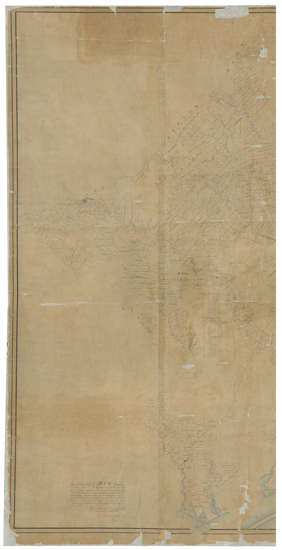
Connected Map of Austin's Colony (1892 tracing)
T-1-4
-
Map/Doc
93358
-
Collection
General Map Collection
-
Object Dates
1892 (Tracing Date)
1837 (Creation Date)
-
People and Organizations
W.L. McGaughey (GLO Commissioner)
Stephen F. Austin (Author)
Gail Borden (Surveyor/Engineer)
John P. Borden (Surveyor/Engineer)
Thomas Borden (Surveyor/Engineer)
F.G. Blau (Draftsman)
J.F. Perry (Author)
-
Subjects
Colony
-
Height x Width
90.8 x 46.7 inches
230.6 x 118.6 cm
-
Comments
1892 certified copy of map no. 1943. See 93359 for east half of map, and 1944 for complete digital composite.
Conservation funded in 2002 with donation from Texas Association of Counties.
Digitized in 2012 with a generous donation from the Daughters of the American Revolution.
Related maps
Connected Map of Austin's Colony

Print $40.00
- Digital $50.00
Connected Map of Austin's Colony
1837
Size 90.6 x 80.9 inches
Map/Doc 1943
Connected Map of Austin's Colony

Print $40.00
- Digital $50.00
Connected Map of Austin's Colony
1837
Size 90.8 x 85.6 inches
Map/Doc 1944
Connected Map of Austin's Colony (1892 tracing)

Print $40.00
- Digital $50.00
Connected Map of Austin's Colony (1892 tracing)
1837
Size 90.8 x 46.5 inches
Map/Doc 93359
Part of: General Map Collection
Brazoria County Working Sketch 38

Print $40.00
- Digital $50.00
Brazoria County Working Sketch 38
1981
Size 53.2 x 37.7 inches
Map/Doc 67523
Hutchinson County Rolled Sketch 6

Print $20.00
- Digital $50.00
Hutchinson County Rolled Sketch 6
1906
Size 33.2 x 24.2 inches
Map/Doc 6278
Jasper County Working Sketch 9

Print $20.00
- Digital $50.00
Jasper County Working Sketch 9
1917
Size 21.0 x 14.3 inches
Map/Doc 66471
Galveston County Rolled Sketch 46

Print $40.00
- Digital $50.00
Galveston County Rolled Sketch 46
2000
Size 32.0 x 48.3 inches
Map/Doc 5981
Freestone County Sketch File 12

Print $6.00
- Digital $50.00
Freestone County Sketch File 12
Size 8.2 x 6.3 inches
Map/Doc 23060
[Beaumont, Sour Lake and Western Ry. Right of Way and Alignment - Frisco]
![64113, [Beaumont, Sour Lake and Western Ry. Right of Way and Alignment - Frisco], General Map Collection](https://historictexasmaps.com/wmedia_w700/maps/64113.tif.jpg)
Print $20.00
- Digital $50.00
[Beaumont, Sour Lake and Western Ry. Right of Way and Alignment - Frisco]
1910
Size 19.9 x 46.3 inches
Map/Doc 64113
San Augustine County Working Sketch 11a

Print $20.00
- Digital $50.00
San Augustine County Working Sketch 11a
Size 18.8 x 24.4 inches
Map/Doc 63698
Pecos County Working Sketch 105

Print $40.00
- Digital $50.00
Pecos County Working Sketch 105
1971
Size 49.3 x 43.5 inches
Map/Doc 71578
Brazoria County Sketch File 49

Print $20.00
- Digital $50.00
Brazoria County Sketch File 49
Size 14.2 x 8.7 inches
Map/Doc 15112
Outer Continental Shelf Leasing Maps (Louisiana Offshore Operations)

Print $20.00
- Digital $50.00
Outer Continental Shelf Leasing Maps (Louisiana Offshore Operations)
1971
Size 20.2 x 15.0 inches
Map/Doc 76092
Lamb County Boundary File 1b

Print $2.00
- Digital $50.00
Lamb County Boundary File 1b
Size 10.9 x 8.8 inches
Map/Doc 56044
Flight Mission No. DQO-8K, Frame 69, Galveston County

Print $20.00
- Digital $50.00
Flight Mission No. DQO-8K, Frame 69, Galveston County
1952
Size 18.8 x 22.5 inches
Map/Doc 85173
You may also like
Hutchinson County Rolled Sketch 40

Print $20.00
- Digital $50.00
Hutchinson County Rolled Sketch 40
1981
Size 26.5 x 37.5 inches
Map/Doc 6306
Flight Mission No. DQO-2K, Frame 149, Galveston County

Print $20.00
- Digital $50.00
Flight Mission No. DQO-2K, Frame 149, Galveston County
1952
Size 18.8 x 22.4 inches
Map/Doc 85046
Bowie County Rolled Sketch 6A

Print $20.00
- Digital $50.00
Bowie County Rolled Sketch 6A
1992
Size 11.3 x 17.8 inches
Map/Doc 5162
Flight Mission No. DAG-21K, Frame 118, Matagorda County

Print $20.00
- Digital $50.00
Flight Mission No. DAG-21K, Frame 118, Matagorda County
1952
Size 18.5 x 18.4 inches
Map/Doc 86443
Flight Mission No. DCL-7C, Frame 143, Kenedy County

Print $20.00
- Digital $50.00
Flight Mission No. DCL-7C, Frame 143, Kenedy County
1943
Size 18.6 x 22.3 inches
Map/Doc 86100
Reagan County Rolled Sketch FF

Print $20.00
- Digital $50.00
Reagan County Rolled Sketch FF
Size 35.0 x 17.8 inches
Map/Doc 7451
Maps & Lists Showing Prison Lands (Oil & Gas) Leased as of June 1955

Digital $50.00
Maps & Lists Showing Prison Lands (Oil & Gas) Leased as of June 1955
Size 8.7 x 11.2 inches
Map/Doc 62869
Wheeler County

Print $20.00
- Digital $50.00
Wheeler County
1932
Size 41.7 x 38.0 inches
Map/Doc 73322
Archer County Sketch File 16

Print $6.00
- Digital $50.00
Archer County Sketch File 16
1889
Size 12.8 x 8.3 inches
Map/Doc 13650
[Surveys near Hondo Creek]
![229, [Surveys near Hondo Creek], General Map Collection](https://historictexasmaps.com/wmedia_w700/maps/229.tif.jpg)
Print $2.00
- Digital $50.00
[Surveys near Hondo Creek]
1846
Size 11.6 x 7.2 inches
Map/Doc 229
Brewster County Rolled Sketch 60

Print $40.00
- Digital $50.00
Brewster County Rolled Sketch 60
Size 36.7 x 50.8 inches
Map/Doc 9200
Flight Mission No. BRA-16M, Frame 114, Jefferson County

Print $20.00
- Digital $50.00
Flight Mission No. BRA-16M, Frame 114, Jefferson County
1953
Size 18.5 x 22.3 inches
Map/Doc 85724