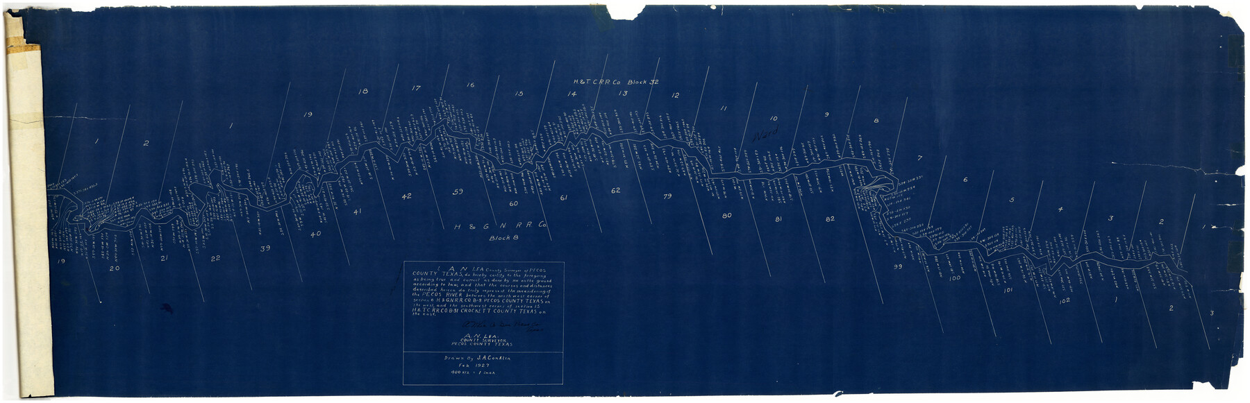
Pecos County Rolled Sketch 141
[Meanders of the Pecos River between the northwest corner of section 19, H. & G. N. R.R. Co. Block 8, Pecos County on the west and the southwest corner of section 1, H. & T. C. R.R. Co. Block 32, Ward County on the east]
-
Map/Doc
10722
-
Collection
General Map Collection
-
Object Dates
2/1927 (Creation Date)
-
People and Organizations
J.A. Conklin (Draftsman)
A.N. Lea (Surveyor/Engineer)
-
Counties
Pecos Ward
-
Subjects
Surveying Rolled Sketch
-
Height x Width
60.5 x 20.4 inches
153.7 x 51.8 cm
-
Medium
blueprint/diazo
-
Scale
1" = 400 varas
Part of: General Map Collection
A How to Get From Here to There Map and Water Too of Metropolitan Houston

A How to Get From Here to There Map and Water Too of Metropolitan Houston
Size 36.7 x 25.5 inches
Map/Doc 94362
McCulloch County Working Sketch 18

Print $20.00
- Digital $50.00
McCulloch County Working Sketch 18
1997
Size 42.9 x 32.8 inches
Map/Doc 70693

Ward County Working Sketch 6

Print $20.00
- Digital $50.00
Ward County Working Sketch 6
1945
Size 23.4 x 24.5 inches
Map/Doc 72312

Jasper County Sketch File 5

Print $4.00
- Digital $50.00
Jasper County Sketch File 5
Size 8.4 x 12.1 inches
Map/Doc 27770
Polk County Working Sketch 30

Print $20.00
- Digital $50.00
Polk County Working Sketch 30
1960
Size 18.2 x 24.4 inches
Map/Doc 71646

Zavala County Rolled Sketch 24

Print $20.00
- Digital $50.00
Zavala County Rolled Sketch 24
1945
Size 21.7 x 18.2 inches
Map/Doc 8327
Flight Mission No. CLL-1N, Frame 101, Willacy County

Print $20.00
- Digital $50.00
Flight Mission No. CLL-1N, Frame 101, Willacy County
1954
Size 18.3 x 22.1 inches
Map/Doc 87035
Taylor County Sketch File 10

Print $20.00
- Digital $50.00
Taylor County Sketch File 10
Size 35.2 x 34.4 inches
Map/Doc 10383
Jim Hogg County Rolled Sketch F

Print $20.00
- Digital $50.00
Jim Hogg County Rolled Sketch F
1930
Size 24.5 x 28.9 inches
Map/Doc 6445
You may also like
[Lynn County School Land Leagues 292, 293, PSL Block C-30, and D. W. RR. Co. Block H]
![90797, [Lynn County School Land Leagues 292, 293, PSL Block C-30, and D. W. RR. Co. Block H], Twichell Survey Records](https://historictexasmaps.com/wmedia_w700/maps/90797-1.tif.jpg)
Print $20.00
- Digital $50.00
[Lynn County School Land Leagues 292, 293, PSL Block C-30, and D. W. RR. Co. Block H]
Size 21.3 x 20.6 inches
Map/Doc 90797
Outline Map showing a new route from Texas to Fort Yuma, California for cattle droves and trains en route to California

Print $40.00
- Digital $50.00
Outline Map showing a new route from Texas to Fort Yuma, California for cattle droves and trains en route to California
1870
Size 17.3 x 52.7 inches
Map/Doc 94048
Map of Goliad County Texas

Print $20.00
- Digital $50.00
Map of Goliad County Texas
1879
Size 19.1 x 21.2 inches
Map/Doc 3589
Liberty County

Print $40.00
- Digital $50.00
Liberty County
1926
Size 49.6 x 52.5 inches
Map/Doc 16879
[Sketch Showing Wm. T. Brewer, John R. Taylor, Wm. F. Butler, Timothy DeVore, L. M. Thorn and adjoining surveys]
![89745, [Sketch Showing Wm. T. Brewer, John R. Taylor, Wm. F. Butler, Timothy DeVore, L. M. Thorn and adjoining surveys], Twichell Survey Records](https://historictexasmaps.com/wmedia_w700/maps/89745-1.tif.jpg)
Print $40.00
- Digital $50.00
[Sketch Showing Wm. T. Brewer, John R. Taylor, Wm. F. Butler, Timothy DeVore, L. M. Thorn and adjoining surveys]
Size 37.1 x 56.1 inches
Map/Doc 89745
Plats of the Resurvey of Clark's Texas-New Mexico Boundary by the U. S. Boundary Commission, 1911

Print $180.00
Plats of the Resurvey of Clark's Texas-New Mexico Boundary by the U. S. Boundary Commission, 1911
1911
Map/Doc 81690
Flight Mission No. CLL-1N, Frame 11, Willacy County

Print $20.00
- Digital $50.00
Flight Mission No. CLL-1N, Frame 11, Willacy County
1954
Size 18.5 x 22.2 inches
Map/Doc 86998
Cameron County Working Sketch 2

Print $40.00
- Digital $50.00
Cameron County Working Sketch 2
1937
Size 43.1 x 51.7 inches
Map/Doc 67881
Newton County Rolled Sketch 5

Print $20.00
- Digital $50.00
Newton County Rolled Sketch 5
Size 20.5 x 42.5 inches
Map/Doc 6841
Montgomery County Sketch File 33

Print $42.00
- Digital $50.00
Montgomery County Sketch File 33
1948
Size 11.2 x 8.8 inches
Map/Doc 31893
Starr County Sketch File 30A

Print $20.00
- Digital $50.00
Starr County Sketch File 30A
1935
Size 21.2 x 23.6 inches
Map/Doc 12334
Map of the Reconnaissance in Texas by Lieuts Blake & Meade of the Corps of Topl. Engrs.

Print $20.00
- Digital $50.00
Map of the Reconnaissance in Texas by Lieuts Blake & Meade of the Corps of Topl. Engrs.
1845
Size 27.6 x 18.2 inches
Map/Doc 72891