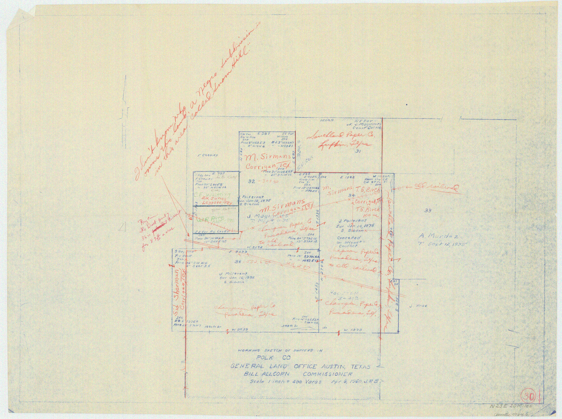
Polk County Working Sketch 30
-
Map/Doc
71646
-
Collection
General Map Collection
-
Object Dates
4/6/1960 (Creation Date)
-
Counties
Polk
-
Subjects
Surveying Working Sketch
-
Height x Width
18.2 x 24.4 inches
46.2 x 62.0 cm
-
Scale
1" = 400 varas
Part of: General Map Collection
Brewster County Working Sketch 41

Print $20.00
- Digital $50.00
Brewster County Working Sketch 41
1945
Size 30.3 x 38.4 inches
Map/Doc 67575
Zavala County Working Sketch Graphic Index

Print $20.00
- Digital $50.00
Zavala County Working Sketch Graphic Index
1977
Size 42.2 x 48.2 inches
Map/Doc 76751
Grayson County Sketch File 6

Print $8.00
- Digital $50.00
Grayson County Sketch File 6
Size 12.9 x 8.2 inches
Map/Doc 24466
Flight Mission No. DQO-2K, Frame 135, Galveston County

Print $20.00
- Digital $50.00
Flight Mission No. DQO-2K, Frame 135, Galveston County
1952
Size 18.7 x 22.5 inches
Map/Doc 85032
Hardin County Sketch File 16a

Print $3.00
- Digital $50.00
Hardin County Sketch File 16a
1837
Size 10.4 x 16.0 inches
Map/Doc 25129
Duval County Rolled Sketch 27

Print $40.00
- Digital $50.00
Duval County Rolled Sketch 27
Size 14.6 x 50.6 inches
Map/Doc 8814
Gulf of Mexico

Print $20.00
- Digital $50.00
Gulf of Mexico
1908
Size 18.3 x 28.0 inches
Map/Doc 72661
Paul McCombs Field Book on 80 Mile Reservation west of the Pecos

Print $148.00
- Digital $50.00
Paul McCombs Field Book on 80 Mile Reservation west of the Pecos
1883
Size 7.8 x 6.0 inches
Map/Doc 2238
Jeff Davis County Rolled Sketch 8

Print $20.00
- Digital $50.00
Jeff Davis County Rolled Sketch 8
Size 40.0 x 41.6 inches
Map/Doc 9264
Oil Development and Structural Map showing Schott, Mirando and other oil fields of the Laredo District with present and proposed development.

Print $20.00
- Digital $50.00
Oil Development and Structural Map showing Schott, Mirando and other oil fields of the Laredo District with present and proposed development.
Size 11.3 x 8.9 inches
Map/Doc 94107
Hydrographic Survey H-1288B Corpus Christi Pass

Print $40.00
- Digital $50.00
Hydrographic Survey H-1288B Corpus Christi Pass
1875
Size 31.8 x 52.5 inches
Map/Doc 2692
Township No. 4 South Range No. 18 West of the Indian Meridian

Print $20.00
- Digital $50.00
Township No. 4 South Range No. 18 West of the Indian Meridian
1875
Size 19.2 x 24.4 inches
Map/Doc 75184
You may also like
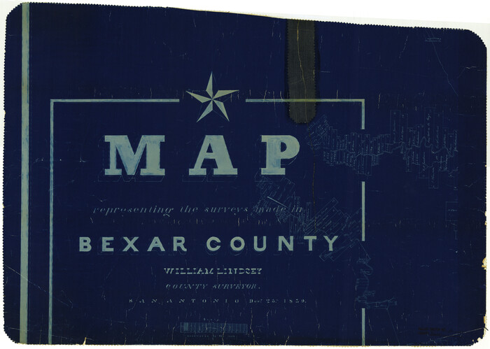
Bexar County Rolled Sketch 2
Print $20.00
- Digital $50.00
Bexar County Rolled Sketch 2
1839
Size 23.2 x 32.5 inches
Map/Doc 5135
Crosby County Sketch File 31

Print $20.00
- Digital $50.00
Crosby County Sketch File 31
Size 35.0 x 14.0 inches
Map/Doc 11257
Reagan County Sketch File 9

Print $20.00
- Digital $50.00
Reagan County Sketch File 9
1928
Size 27.0 x 22.3 inches
Map/Doc 12216
Jackson County Working Sketch Graphic Index

Print $20.00
- Digital $50.00
Jackson County Working Sketch Graphic Index
1920
Size 47.0 x 40.3 inches
Map/Doc 76590
Armstrong County

Print $20.00
- Digital $50.00
Armstrong County
1933
Size 42.3 x 41.0 inches
Map/Doc 73071
McCulloch County Boundary File 2

Print $6.00
- Digital $50.00
McCulloch County Boundary File 2
Size 12.9 x 8.3 inches
Map/Doc 56908
Flight Mission No. DQN-2K, Frame 196, Calhoun County

Print $20.00
- Digital $50.00
Flight Mission No. DQN-2K, Frame 196, Calhoun County
1953
Size 16.3 x 16.1 inches
Map/Doc 84335
Flight Mission No. CRC-3R, Frame 51, Chambers County

Print $20.00
- Digital $50.00
Flight Mission No. CRC-3R, Frame 51, Chambers County
1956
Size 18.7 x 22.4 inches
Map/Doc 84824
Ector County Sketch File 10

Print $8.00
- Digital $50.00
Ector County Sketch File 10
1930
Size 11.6 x 9.0 inches
Map/Doc 21639
Borden County Rolled Sketch 12

Print $40.00
- Digital $50.00
Borden County Rolled Sketch 12
1964
Size 48.1 x 31.6 inches
Map/Doc 8451
Garza County Rolled Sketch 3

Print $20.00
- Digital $50.00
Garza County Rolled Sketch 3
1900
Size 32.7 x 47.7 inches
Map/Doc 75937
Van Zandt County Working Sketch 6a

Print $40.00
- Digital $50.00
Van Zandt County Working Sketch 6a
1941
Size 57.2 x 25.7 inches
Map/Doc 69762