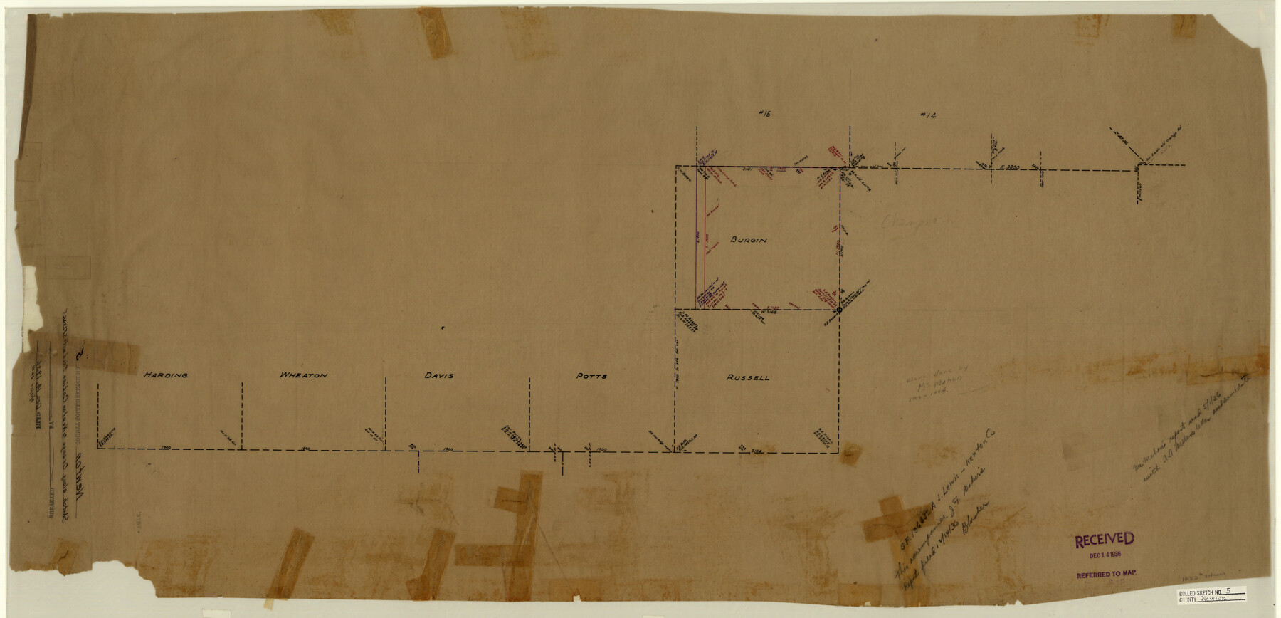
Newton County Rolled Sketch 5
[Sketch along Newton-Orange County line filed with SF-13665]
-
Map/Doc
6841
-
Collection
General Map Collection
-
Object Dates
1936/12/14 (File Date)
-
Counties
Newton
-
Subjects
Surveying Rolled Sketch
-
Height x Width
20.5 x 42.5 inches
52.1 x 108.0 cm
-
Medium
paper, manuscript
Part of: General Map Collection
Starr County Boundary File 1

Print $24.00
- Digital $50.00
Starr County Boundary File 1
Size 13.0 x 8.5 inches
Map/Doc 58801
Frio County Working Sketch 22

Print $20.00
- Digital $50.00
Frio County Working Sketch 22
1990
Size 24.9 x 33.9 inches
Map/Doc 69296
Jefferson Co.

Print $20.00
- Digital $50.00
Jefferson Co.
1918
Size 46.7 x 40.8 inches
Map/Doc 16860
Gillespie County Working Sketch 1

Print $20.00
- Digital $50.00
Gillespie County Working Sketch 1
1950
Size 23.9 x 18.7 inches
Map/Doc 63164
Flight Mission No. BQY-4M, Frame 69, Harris County

Print $20.00
- Digital $50.00
Flight Mission No. BQY-4M, Frame 69, Harris County
1953
Size 18.6 x 22.4 inches
Map/Doc 85278
Map of Colorado County

Print $20.00
- Digital $50.00
Map of Colorado County
1871
Size 18.4 x 19.1 inches
Map/Doc 4594
Connected Map of Austin's Colony

Print $20.00
- Digital $50.00
Connected Map of Austin's Colony
1892
Size 47.3 x 43.3 inches
Map/Doc 76075
Harris County Sketch File 24

Print $8.00
- Digital $50.00
Harris County Sketch File 24
Size 8.8 x 8.0 inches
Map/Doc 25385
Coast Chart No. 212 - From Latitude 26° 33' to the Rio Grande Texas

Print $20.00
- Digital $50.00
Coast Chart No. 212 - From Latitude 26° 33' to the Rio Grande Texas
1886
Size 18.3 x 24.1 inches
Map/Doc 72835
Red River County
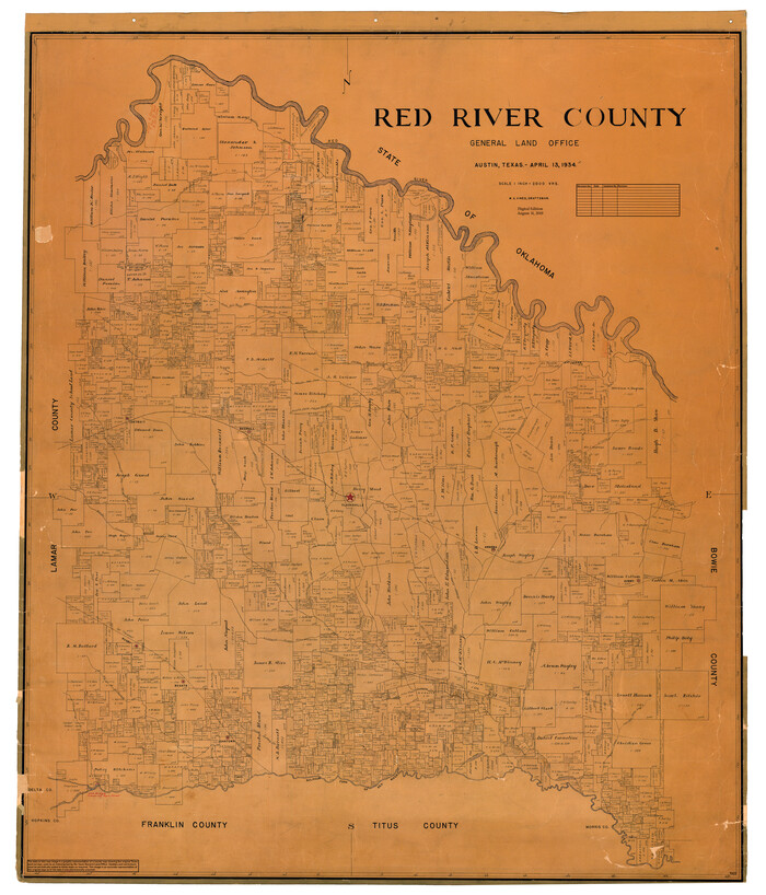
Print $20.00
- Digital $50.00
Red River County
1934
Size 47.0 x 40.2 inches
Map/Doc 95623
Williamson County Boundary File 1a

Print $4.00
- Digital $50.00
Williamson County Boundary File 1a
Size 11.0 x 8.4 inches
Map/Doc 59990
No. 3 Chart of Channel connecting Corpus Christi Bay with Aransas Bay, Texas

Print $20.00
- Digital $50.00
No. 3 Chart of Channel connecting Corpus Christi Bay with Aransas Bay, Texas
1878
Size 18.2 x 28.0 inches
Map/Doc 72772
You may also like
Motley County Sketch File 3 (N)

Print $22.00
- Digital $50.00
Motley County Sketch File 3 (N)
Size 9.1 x 13.0 inches
Map/Doc 31998
Map of Texas with Parts of the Adjoining States

Print $20.00
Map of Texas with Parts of the Adjoining States
1833
Size 29.3 x 23.3 inches
Map/Doc 79740
Houston County Working Sketch 10

Print $20.00
- Digital $50.00
Houston County Working Sketch 10
1953
Size 32.7 x 27.3 inches
Map/Doc 66240
San Saba County Sketch File 14a

Print $14.00
- Digital $50.00
San Saba County Sketch File 14a
1891
Size 14.5 x 8.8 inches
Map/Doc 36441
Crane County Sketch File 20

Print $4.00
- Digital $50.00
Crane County Sketch File 20
1928
Size 14.4 x 9.0 inches
Map/Doc 19588
Travis County Appraisal District Plat Map 1_1808

Print $20.00
- Digital $50.00
Travis County Appraisal District Plat Map 1_1808
Size 21.5 x 26.5 inches
Map/Doc 94214
Flight Mission No. DAG-24K, Frame 45, Matagorda County

Print $20.00
- Digital $50.00
Flight Mission No. DAG-24K, Frame 45, Matagorda County
1953
Size 18.6 x 22.2 inches
Map/Doc 86532
Map of the City of Corsicana (Navarro County) Texas

Print $40.00
- Digital $50.00
Map of the City of Corsicana (Navarro County) Texas
1963
Size 43.2 x 92.3 inches
Map/Doc 93673
Galveston County Sketch File 64

Print $44.00
- Digital $50.00
Galveston County Sketch File 64
1984
Size 31.5 x 25.5 inches
Map/Doc 11542
City of Lamesa, Texas

Print $40.00
- Digital $50.00
City of Lamesa, Texas
Size 52.2 x 43.2 inches
Map/Doc 89855
Map of Galveston West Bay, Galveston Island & Chocolate Bay

Print $40.00
- Digital $50.00
Map of Galveston West Bay, Galveston Island & Chocolate Bay
1852
Size 50.5 x 29.9 inches
Map/Doc 69924
Fractional Township No. 9 South Range No. 24 East of the Indian Meridian, Indian Territory

Print $20.00
- Digital $50.00
Fractional Township No. 9 South Range No. 24 East of the Indian Meridian, Indian Territory
1898
Size 19.2 x 24.3 inches
Map/Doc 75241