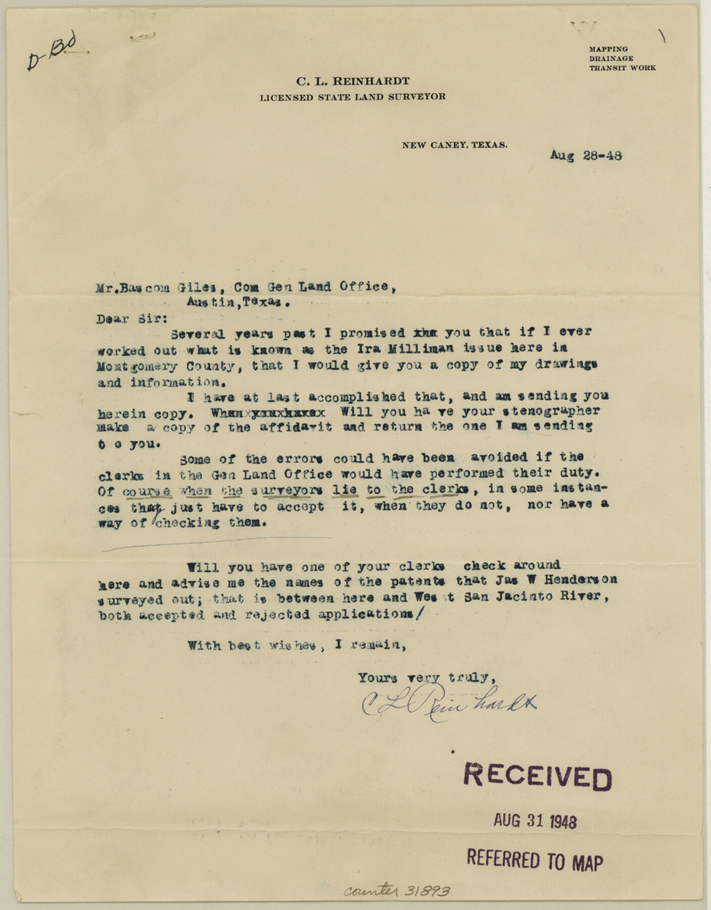
Montgomery County Sketch File 33
[Report, affidavit, correspondence, and copy of sketch of area in the vicinity of the Ira Milliman and Chas. Stephens surveys in the southeast part of the county]
-
Map/Doc
31893
-
Collection
General Map Collection
-
Object Dates
1948 (Creation Date)
-
People and Organizations
C.L. Reinhardt (Surveyor/Engineer)
-
Counties
Montgomery
-
Subjects
Surveying Sketch File
-
Height x Width
11.2 x 8.8 inches
28.5 x 22.4 cm
-
Medium
multi-page, multi-format
-
Scale
1" = 150 varas
-
Comments
See Montgomery County Sketch File 33A (42124).
-
Features
West San Jacinto River
New Caney
Dry Creek
Cold Springs
Danville
Lynchburg
Spring Creek
Hester Highway
Houston-Danville Road
Houston
New Caney Road
Highway 59
Caney Creek
New Caney School
Related maps
Montgomery County Sketch File 33A

Print $20.00
- Digital $50.00
Montgomery County Sketch File 33A
1948
Size 21.3 x 28.3 inches
Map/Doc 42124
Part of: General Map Collection
Val Verde County Working Sketch 6

Print $20.00
- Digital $50.00
Val Verde County Working Sketch 6
1915
Size 23.2 x 20.7 inches
Map/Doc 72141
Eastland County Working Sketch 60a

Print $20.00
- Digital $50.00
Eastland County Working Sketch 60a
1988
Size 45.1 x 39.0 inches
Map/Doc 78209
University Lands as resurveyed by Frank F. Friend, Special Surveyor, San Angelo, Texas projected on a map of the State of Texas

Print $40.00
- Digital $50.00
University Lands as resurveyed by Frank F. Friend, Special Surveyor, San Angelo, Texas projected on a map of the State of Texas
1936
Size 31.0 x 55.8 inches
Map/Doc 2418
Hamilton County Working Sketch 9

Print $20.00
- Digital $50.00
Hamilton County Working Sketch 9
1946
Size 31.3 x 24.0 inches
Map/Doc 63347
Jackson County Sketch File 27

Print $20.00
- Digital $50.00
Jackson County Sketch File 27
1938
Size 25.6 x 24.8 inches
Map/Doc 11847
[Edwards County]
![4940, [Edwards County], General Map Collection](https://historictexasmaps.com/wmedia_w700/maps/4940-1.tif.jpg)
Print $40.00
- Digital $50.00
[Edwards County]
1900
Size 48.7 x 32.7 inches
Map/Doc 4940
Dallas County Sketch File 21

Print $22.00
- Digital $50.00
Dallas County Sketch File 21
1888
Size 14.2 x 8.9 inches
Map/Doc 20443
Hudspeth County Rolled Sketch 69

Print $20.00
- Digital $50.00
Hudspeth County Rolled Sketch 69
1973
Size 12.3 x 19.8 inches
Map/Doc 6264
Sutton County Sketch File 33a-b

Print $7.00
- Digital $50.00
Sutton County Sketch File 33a-b
1934
Size 8.4 x 8.4 inches
Map/Doc 37469
Galveston Bay Entrance - Galveston and Texas City Harbors

Print $40.00
- Digital $50.00
Galveston Bay Entrance - Galveston and Texas City Harbors
1971
Size 33.4 x 50.1 inches
Map/Doc 69861
Mason County Sketch File 23

Print $42.00
- Digital $50.00
Mason County Sketch File 23
1932
Size 11.2 x 8.8 inches
Map/Doc 30723
Freestone County Sketch File 7

Print $4.00
- Digital $50.00
Freestone County Sketch File 7
1861
Size 14.4 x 8.3 inches
Map/Doc 23052
You may also like
Concho County Sketch File 25

Print $8.00
- Digital $50.00
Concho County Sketch File 25
1885
Size 11.4 x 9.0 inches
Map/Doc 19155
General Highway Map, Travis County, Texas

Print $20.00
General Highway Map, Travis County, Texas
1961
Size 18.2 x 24.7 inches
Map/Doc 79680
The Mexican Municipality of Mina. Created, April 1834

Print $20.00
The Mexican Municipality of Mina. Created, April 1834
2020
Size 10.7 x 21.7 inches
Map/Doc 96028
McLennan County Sketch File 4

Print $4.00
- Digital $50.00
McLennan County Sketch File 4
1852
Size 12.7 x 8.2 inches
Map/Doc 31235
J. De Cordova's Map of the State of Texas Compiled from the records of the General Land Office of the State

Print $20.00
J. De Cordova's Map of the State of Texas Compiled from the records of the General Land Office of the State
1856
Size 34.2 x 32.1 inches
Map/Doc 76222
Stonewall County Working Sketch 22

Print $20.00
- Digital $50.00
Stonewall County Working Sketch 22
1966
Size 44.2 x 32.9 inches
Map/Doc 62329
Parker County Sketch File 47

Print $20.00
- Digital $50.00
Parker County Sketch File 47
1857
Size 16.4 x 34.7 inches
Map/Doc 12151
[Block K5, Section 13]
![91451, [Block K5, Section 13], Twichell Survey Records](https://historictexasmaps.com/wmedia_w700/maps/91451-1.tif.jpg)
Print $3.00
- Digital $50.00
[Block K5, Section 13]
Size 11.4 x 10.4 inches
Map/Doc 91451
Montgomery County Working Sketch 50

Print $20.00
- Digital $50.00
Montgomery County Working Sketch 50
1959
Size 25.3 x 21.9 inches
Map/Doc 71157
Flight Mission No. CGI-1N, Frame 134, Cameron County

Print $20.00
- Digital $50.00
Flight Mission No. CGI-1N, Frame 134, Cameron County
1955
Size 18.5 x 22.1 inches
Map/Doc 84490
Mills County Boundary File 10

Print $46.00
- Digital $50.00
Mills County Boundary File 10
Size 17.0 x 11.6 inches
Map/Doc 57329
Brewster County Sketch File 42

Print $40.00
- Digital $50.00
Brewster County Sketch File 42
1914
Size 11.5 x 19.0 inches
Map/Doc 10981