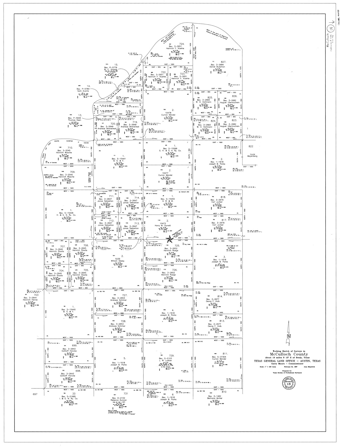
McCulloch County Working Sketch 18
-
Map/Doc
70693
-
Collection
General Map Collection
-
Object Dates
2/24/1997 (Creation Date)
-
People and Organizations
Joan Kilpatrick (Draftsman)
-
Counties
McCulloch
-
Subjects
Surveying Working Sketch
-
Height x Width
42.9 x 32.8 inches
109.0 x 83.3 cm
-
Scale
1" = 400 varas
Part of: General Map Collection
Falls County Sketch File 33

Print $4.00
- Digital $50.00
Falls County Sketch File 33
1873
Size 10.3 x 8.3 inches
Map/Doc 22441
Flight Mission No. CLL-1N, Frame 188, Willacy County

Print $20.00
- Digital $50.00
Flight Mission No. CLL-1N, Frame 188, Willacy County
1954
Size 18.4 x 22.0 inches
Map/Doc 87058
New Counties in the Panhandle

Print $20.00
- Digital $50.00
New Counties in the Panhandle
Size 24.4 x 21.3 inches
Map/Doc 69765
Dallas County Rolled Sketch 5

Print $20.00
- Digital $50.00
Dallas County Rolled Sketch 5
1955
Size 23.8 x 30.8 inches
Map/Doc 5689
Wichita County Sketch File 8

Print $4.00
- Digital $50.00
Wichita County Sketch File 8
1860
Size 11.7 x 8.2 inches
Map/Doc 40048
North Shore of West Bay and Galveston Island

Print $40.00
- Digital $50.00
North Shore of West Bay and Galveston Island
1933
Size 37.4 x 57.7 inches
Map/Doc 69930
Upton County Sketch File 34

Print $40.00
- Digital $50.00
Upton County Sketch File 34
1941
Size 16.2 x 12.2 inches
Map/Doc 38884
Intracoastal Waterway in Texas - Corpus Christi to Point Isabel including Arroyo Colorado to Mo. Pac. R.R. Bridge Near Harlingen

Print $20.00
- Digital $50.00
Intracoastal Waterway in Texas - Corpus Christi to Point Isabel including Arroyo Colorado to Mo. Pac. R.R. Bridge Near Harlingen
1933
Size 28.4 x 41.2 inches
Map/Doc 61870
Kinney County Sketch File 38

Print $8.00
- Digital $50.00
Kinney County Sketch File 38
1882
Size 14.3 x 8.7 inches
Map/Doc 29188
Dickens County Boundary File 1

Print $6.00
- Digital $50.00
Dickens County Boundary File 1
Size 8.8 x 3.7 inches
Map/Doc 52530
Jim Hogg County Working Sketch 12

Print $20.00
- Digital $50.00
Jim Hogg County Working Sketch 12
1984
Size 17.4 x 15.2 inches
Map/Doc 66598

You may also like
Flight Mission No. DQO-11K, Frame 17, Galveston County

Print $20.00
- Digital $50.00
Flight Mission No. DQO-11K, Frame 17, Galveston County
1952
Size 18.7 x 22.4 inches
Map/Doc 85210

[Capitol Leagues 217-228, 238, and vicinity]
![90674, [Capitol Leagues 217-228, 238, and vicinity], Twichell Survey Records](https://historictexasmaps.com/wmedia_w700/maps/90674-1.tif.jpg)
Print $20.00
- Digital $50.00
[Capitol Leagues 217-228, 238, and vicinity]
Size 22.8 x 10.0 inches
Map/Doc 90674
Coke County Working Sketch 17

Print $20.00
- Digital $50.00
Coke County Working Sketch 17
1948
Size 18.2 x 19.4 inches
Map/Doc 68054
McMullen County Rolled Sketch 11

Print $20.00
- Digital $50.00
McMullen County Rolled Sketch 11
Size 32.2 x 22.3 inches
Map/Doc 6728
[Sketch for Mineral Application 24072, San Jacinto River]
![65599, [Sketch for Mineral Application 24072, San Jacinto River], General Map Collection](https://historictexasmaps.com/wmedia_w700/maps/65599.tif.jpg)
Print $20.00
- Digital $50.00
[Sketch for Mineral Application 24072, San Jacinto River]
1929
Size 23.5 x 18.0 inches
Map/Doc 65599

Knox County Working Sketch Graphic Index

Print $20.00
- Digital $50.00
Knox County Working Sketch Graphic Index
1923
Size 44.8 x 39.4 inches
Map/Doc 76611
Grayson County Working Sketch 20

Print $20.00
- Digital $50.00
Grayson County Working Sketch 20
1956
Size 25.4 x 31.3 inches
Map/Doc 63259
Wharton County Working Sketch 2

Print $20.00
- Digital $50.00
Wharton County Working Sketch 2
Size 29.3 x 37.3 inches
Map/Doc 72466
General Highway Map, San Jacinto County, Texas

Print $20.00
General Highway Map, San Jacinto County, Texas
1940
Size 24.9 x 18.4 inches
Map/Doc 79236
Nueces County Rolled Sketch 62

Print $20.00
- Digital $50.00
Nueces County Rolled Sketch 62
1977
Size 25.0 x 33.3 inches
Map/Doc 6908