Taylor County Sketch File 10
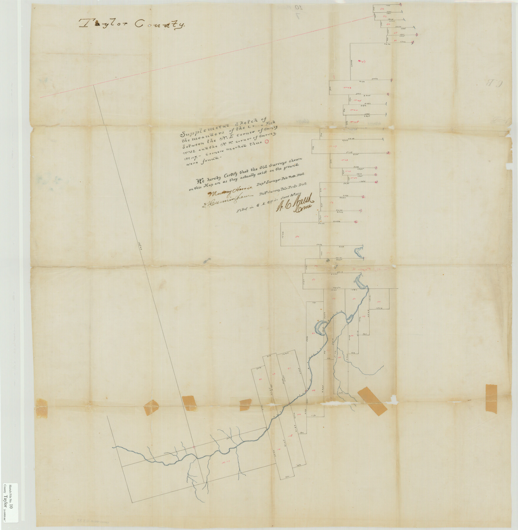
[Supplemental sketch of the meanders of Elm Creek between the NE corner of survey no. 32 and the NW corner of survey no. 117]
-
Map/Doc
10383
-
Collection
General Map Collection
-
Object Dates
6/30/1879 (File Date)
-
People and Organizations
Murray Harris (Surveyor/Engineer)
D.L. Cunningham (Surveyor/Engineer)
-
Counties
Taylor
-
Subjects
Surveying Sketch File
-
Height x Width
35.2 x 34.4 inches
89.4 x 87.4 cm
-
Medium
paper, manuscript
-
Features
Elm Creek
Part of: General Map Collection
Blanco County Working Sketch 13

Print $20.00
- Digital $50.00
Blanco County Working Sketch 13
1948
Size 42.6 x 33.6 inches
Map/Doc 67373
Duval County Rolled Sketch HD

Print $20.00
- Digital $50.00
Duval County Rolled Sketch HD
1939
Size 22.8 x 32.8 inches
Map/Doc 5767
Gillespie County Working Sketch 11

Print $20.00
- Digital $50.00
Gillespie County Working Sketch 11
2007
Size 27.8 x 38.0 inches
Map/Doc 87212
Amistad International Reservoir on Rio Grande Key Sheet

Print $20.00
- Digital $50.00
Amistad International Reservoir on Rio Grande Key Sheet
1960
Size 13.0 x 32.4 inches
Map/Doc 73345
Henderson County Working Sketch 43

Print $20.00
- Digital $50.00
Henderson County Working Sketch 43
1994
Size 36.7 x 39.0 inches
Map/Doc 66176
[Surveys along the Colorado River]
![119, [Surveys along the Colorado River], General Map Collection](https://historictexasmaps.com/wmedia_w700/maps/119.tif.jpg)
Print $20.00
- Digital $50.00
[Surveys along the Colorado River]
1840
Size 23.8 x 17.9 inches
Map/Doc 119
Hemphill County Sketch File 1

Print $40.00
- Digital $50.00
Hemphill County Sketch File 1
Size 17.1 x 13.9 inches
Map/Doc 26279
Houston County Working Sketch 20

Print $20.00
- Digital $50.00
Houston County Working Sketch 20
1979
Size 26.7 x 24.0 inches
Map/Doc 66250
Bexar County Sketch File 31

Print $40.00
- Digital $50.00
Bexar County Sketch File 31
1867
Size 11.3 x 16.4 inches
Map/Doc 10920
Flight Mission No. BQR-14K, Frame 38, Brazoria County

Print $20.00
- Digital $50.00
Flight Mission No. BQR-14K, Frame 38, Brazoria County
1952
Size 18.8 x 22.3 inches
Map/Doc 84095
Map of Harris County

Print $20.00
- Digital $50.00
Map of Harris County
1893
Size 26.9 x 36.5 inches
Map/Doc 66855
Tom Green County Boundary File 5

Print $44.00
- Digital $50.00
Tom Green County Boundary File 5
Size 14.4 x 8.8 inches
Map/Doc 59363
You may also like
Atlas Pintoresco e Historico de los Estados Unidos Mexicanos

Atlas Pintoresco e Historico de los Estados Unidos Mexicanos
Map/Doc 96796
Map of the Western Part of Travis County, Texas

Print $20.00
- Digital $50.00
Map of the Western Part of Travis County, Texas
1919
Size 36.2 x 29.9 inches
Map/Doc 10754
Moore County Working Sketch 2

Print $20.00
- Digital $50.00
Moore County Working Sketch 2
1934
Size 18.3 x 41.3 inches
Map/Doc 71184
Louisiana and Texas Intracoastal Waterway, Section 7, Galveston Bay to Brazos River and Section 8, Brazos River to Matagorda Bay

Print $20.00
- Digital $50.00
Louisiana and Texas Intracoastal Waterway, Section 7, Galveston Bay to Brazos River and Section 8, Brazos River to Matagorda Bay
1929
Size 30.8 x 43.0 inches
Map/Doc 61842
Map of the Rio Grande and Pecos Railway showing its connections with…

Print $20.00
Map of the Rio Grande and Pecos Railway showing its connections with…
1882
Size 42.1 x 40.2 inches
Map/Doc 93620
Sketch Showing Lands Southeast of Creek Outside of H. C. Sisco's Area, Exhibit H

Print $20.00
- Digital $50.00
Sketch Showing Lands Southeast of Creek Outside of H. C. Sisco's Area, Exhibit H
Size 20.0 x 24.5 inches
Map/Doc 91373
Palo Pinto County

Print $40.00
- Digital $50.00
Palo Pinto County
1941
Size 48.3 x 39.4 inches
Map/Doc 66966
Jones County Sketch File 21

Print $56.00
- Digital $50.00
Jones County Sketch File 21
2010
Map/Doc 93292
Flight Mission No. DQN-1K, Frame 143, Calhoun County

Print $20.00
- Digital $50.00
Flight Mission No. DQN-1K, Frame 143, Calhoun County
1953
Size 18.5 x 22.1 inches
Map/Doc 84206
Carson County Sketch File 6a

Print $10.00
- Digital $50.00
Carson County Sketch File 6a
1928
Size 14.1 x 8.4 inches
Map/Doc 17374
[Beaumont, Sour Lake and Western Ry. Right of Way and Alignment - Frisco]
![64112, [Beaumont, Sour Lake and Western Ry. Right of Way and Alignment - Frisco], General Map Collection](https://historictexasmaps.com/wmedia_w700/maps/64112.tif.jpg)
Print $20.00
- Digital $50.00
[Beaumont, Sour Lake and Western Ry. Right of Way and Alignment - Frisco]
1910
Size 20.3 x 46.0 inches
Map/Doc 64112
Comal County Sketch File 18

Print $4.00
- Digital $50.00
Comal County Sketch File 18
Size 6.7 x 13.0 inches
Map/Doc 19037