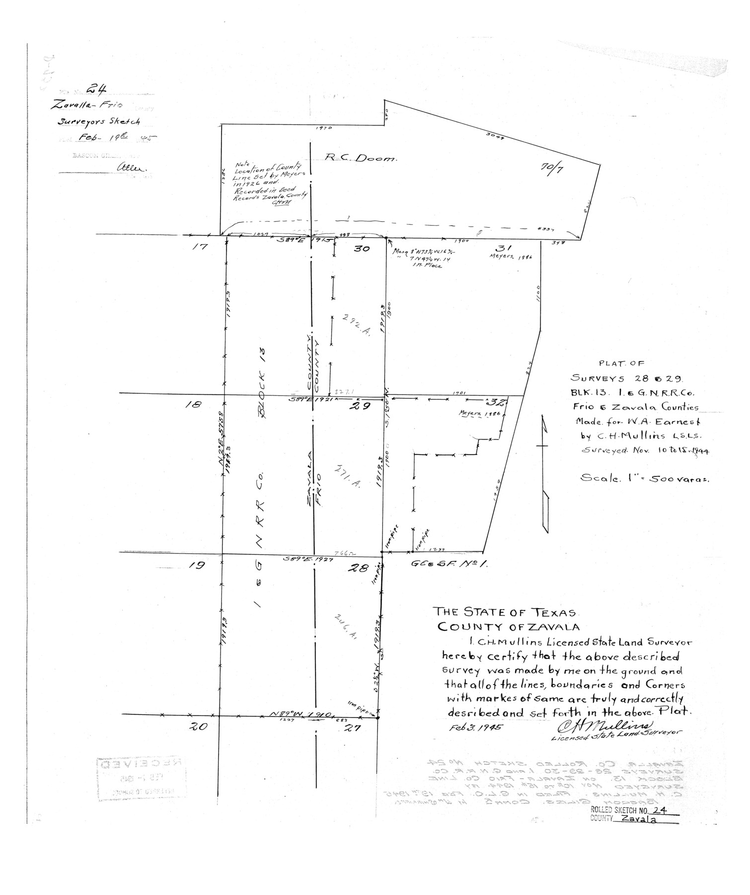
Zavala County Rolled Sketch 24
Plat of surveys 28 & 29, Blk. 13, I. & G. N. R.R. Co., Frio & Zavala Counties made for W.A. Earnest
-
Map/Doc
8327
-
Collection
General Map Collection
-
Object Dates
1944/11/15 (Survey Date)
1945/2/19 (File Date)
1945/2/3 (Creation Date)
-
People and Organizations
C.H. Mullins (Surveyor/Engineer)
-
Counties
Zavala Frio
-
Subjects
Surveying Rolled Sketch
-
Height x Width
21.7 x 18.2 inches
55.1 x 46.2 cm
-
Medium
linen, manuscript
-
Scale
1" = 500 varas
Part of: General Map Collection
Bell County Sketch File 9

Print $4.00
- Digital $50.00
Bell County Sketch File 9
Size 10.0 x 8.2 inches
Map/Doc 14379
Austin's colony 1821-1836: In commemoration of the two hundredth birthday of Stephen F. Austin

Print $20.00
- Digital $50.00
Austin's colony 1821-1836: In commemoration of the two hundredth birthday of Stephen F. Austin
1993
Size 24.6 x 34.5 inches
Map/Doc 1675
Sabine Pass and Lake

Print $40.00
- Digital $50.00
Sabine Pass and Lake
1992
Size 49.2 x 28.6 inches
Map/Doc 69828
Kerr County State Real Property Sketch 2

Print $2.00
- Digital $50.00
Kerr County State Real Property Sketch 2
2007
Size 10.7 x 8.6 inches
Map/Doc 88675
Parker County Sketch File 16

Print $22.00
- Digital $50.00
Parker County Sketch File 16
1870
Size 12.9 x 16.3 inches
Map/Doc 33550
Leon County Working Sketch 24

Print $20.00
- Digital $50.00
Leon County Working Sketch 24
1967
Size 23.3 x 29.0 inches
Map/Doc 70423
Montgomery County Rolled Sketch 51

Print $20.00
- Digital $50.00
Montgomery County Rolled Sketch 51
2021
Map/Doc 97369
Trinity County Sketch File 16

Print $4.00
- Digital $50.00
Trinity County Sketch File 16
1879
Size 8.2 x 11.1 inches
Map/Doc 38544
Glasscock County Rolled Sketch 1

Print $20.00
- Digital $50.00
Glasscock County Rolled Sketch 1
1906
Size 37.3 x 33.6 inches
Map/Doc 9055
Wise County Working Sketch 8

Print $20.00
- Digital $50.00
Wise County Working Sketch 8
1953
Size 13.0 x 11.1 inches
Map/Doc 72622
Galveston County Working Sketch 16

Print $20.00
- Digital $50.00
Galveston County Working Sketch 16
1980
Size 30.5 x 36.9 inches
Map/Doc 69353
Sutton County Working Sketch 9

Print $20.00
- Digital $50.00
Sutton County Working Sketch 9
1972
Size 41.8 x 38.1 inches
Map/Doc 62352
You may also like
Harris County Working Sketch 28

Print $20.00
- Digital $50.00
Harris County Working Sketch 28
Size 34.4 x 43.1 inches
Map/Doc 65920
Erforschung von Nordwest-Texas

Print $20.00
- Digital $50.00
Erforschung von Nordwest-Texas
1873
Size 11.4 x 9.4 inches
Map/Doc 95144
Plat Showing Subdivision of Howard County School Land Hockley County, Texas

Print $20.00
- Digital $50.00
Plat Showing Subdivision of Howard County School Land Hockley County, Texas
1947
Size 13.9 x 28.1 inches
Map/Doc 92256
Index to Burnet's, [Vehlein's] & Zavala's Colonies
![94553, Index to Burnet's, [Vehlein's] & Zavala's Colonies, Historical Volumes](https://historictexasmaps.com/wmedia_w700/pdf_converted_jpg/qi_pdf_thumbnail_39142.jpg)
Index to Burnet's, [Vehlein's] & Zavala's Colonies
Map/Doc 94553
Sutton County Rolled Sketch 54

Print $20.00
- Digital $50.00
Sutton County Rolled Sketch 54
Size 32.4 x 27.7 inches
Map/Doc 7894
General Highway Map, Limestone County, Texas

Print $20.00
General Highway Map, Limestone County, Texas
1940
Size 18.3 x 24.9 inches
Map/Doc 79174
Jasper County Working Sketch 6

Print $20.00
- Digital $50.00
Jasper County Working Sketch 6
1914
Size 15.9 x 11.3 inches
Map/Doc 66468
Map of Kinney County

Print $40.00
- Digital $50.00
Map of Kinney County
1889
Size 50.1 x 41.1 inches
Map/Doc 16869
Dimmit County Rolled Sketch 11

Print $20.00
- Digital $50.00
Dimmit County Rolled Sketch 11
1942
Size 21.8 x 28.9 inches
Map/Doc 5720
Right of Way and Track Map, the Missouri, Kansas and Texas Ry. of Texas - Henrietta Division

Print $20.00
- Digital $50.00
Right of Way and Track Map, the Missouri, Kansas and Texas Ry. of Texas - Henrietta Division
1918
Size 11.8 x 26.8 inches
Map/Doc 64750
Reeves County Working Sketch 50

Print $20.00
- Digital $50.00
Reeves County Working Sketch 50
1974
Size 45.3 x 30.4 inches
Map/Doc 63493
[J. E. and J. W. Rhea's Ranch situated in Parmer Co., Texas]
![91652, [J. E. and J. W. Rhea's Ranch situated in Parmer Co., Texas], Twichell Survey Records](https://historictexasmaps.com/wmedia_w700/maps/91652-1.tif.jpg)
Print $20.00
- Digital $50.00
[J. E. and J. W. Rhea's Ranch situated in Parmer Co., Texas]
Size 23.2 x 25.8 inches
Map/Doc 91652