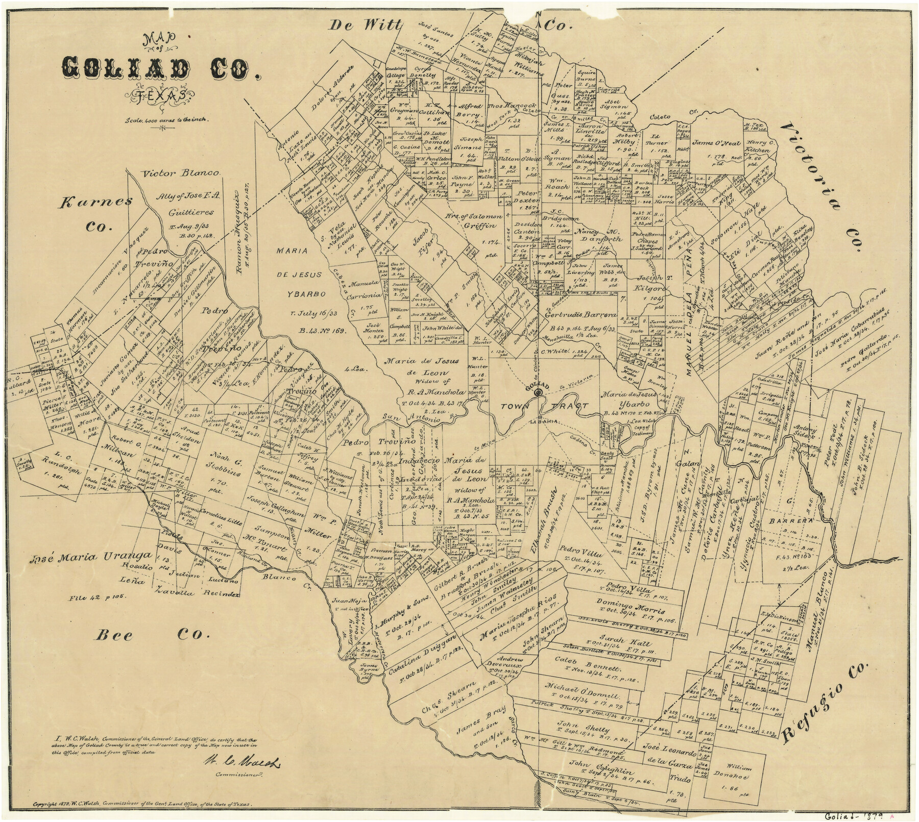
Map of Goliad County Texas
-
Map/Doc
3589
-
Collection
General Map Collection
-
Object Dates
1879 (Creation Date)
-
People and Organizations
Texas General Land Office (Publisher)
W.C. Walsh (GLO Commissioner)
-
Counties
Goliad
-
Subjects
County
-
Height x Width
19.1 x 21.2 inches
48.5 x 53.9 cm
-
Comments
Copyrighted 1879.
-
Features
Kilgore Creek
Blanco Creek
Cadena Creek
West Fork of 18 Miles Creek
Sarco Creek
Macorrera Creek
Richland Creek
Miller's Creek
Perdido Creek
Manahuilla Creek
Cabeza Creek
Coleto Creek
West Fork of Coleto Creek
Little Perdido Creek
Turkey Creek
Rock Creek
Hosier Creek
[Road] to Guadalupe
San Antonio River
La Bahia
Goliad
[Road] to Mica
[Road] to Victoria
[Road] to Clinton
Part of: General Map Collection
Wilbarger Co.

Print $40.00
- Digital $50.00
Wilbarger Co.
1949
Size 48.2 x 39.2 inches
Map/Doc 63128
Hays County Boundary File 1

Print $14.00
- Digital $50.00
Hays County Boundary File 1
Size 9.5 x 5.2 inches
Map/Doc 54586
Midland County Sketch File 18

Print $4.00
- Digital $50.00
Midland County Sketch File 18
Size 14.7 x 8.1 inches
Map/Doc 31585
Kaufman County Sketch File 1

Print $4.00
- Digital $50.00
Kaufman County Sketch File 1
Size 8.3 x 8.3 inches
Map/Doc 28624
Wilbarger County Working Sketch 15

Print $20.00
- Digital $50.00
Wilbarger County Working Sketch 15
1955
Size 32.5 x 25.5 inches
Map/Doc 72553
Map of north end of Brazos Island

Print $20.00
- Digital $50.00
Map of north end of Brazos Island
Size 27.7 x 18.3 inches
Map/Doc 72907
San Patricio County NRC Article 33.136 Sketch 4

Print $3.00
- Digital $50.00
San Patricio County NRC Article 33.136 Sketch 4
Size 11.0 x 17.0 inches
Map/Doc 94695
[Gulf, Colorado & Santa Fe]
![64574, [Gulf, Colorado & Santa Fe], General Map Collection](https://historictexasmaps.com/wmedia_w700/maps/64574.tif.jpg)
Print $40.00
- Digital $50.00
[Gulf, Colorado & Santa Fe]
Size 32.8 x 126.0 inches
Map/Doc 64574
Gulf Intracoastal Waterway - Tributary Channel to Aransas Pass, Location of Spoil Disposal Areas

Print $20.00
- Digital $50.00
Gulf Intracoastal Waterway - Tributary Channel to Aransas Pass, Location of Spoil Disposal Areas
1961
Size 31.5 x 41.9 inches
Map/Doc 61828
Crockett County Working Sketch 43

Print $20.00
- Digital $50.00
Crockett County Working Sketch 43
1931
Size 26.1 x 21.7 inches
Map/Doc 68376
Motley County Sketch File 3A (N)

Print $20.00
- Digital $50.00
Motley County Sketch File 3A (N)
Size 12.3 x 17.5 inches
Map/Doc 42136
Clay County Sketch File 4

Print $22.00
- Digital $50.00
Clay County Sketch File 4
1854
Size 5.0 x 7.5 inches
Map/Doc 18392
You may also like
Travis County Working Sketch 12

Print $20.00
- Digital $50.00
Travis County Working Sketch 12
1920
Size 47.8 x 26.1 inches
Map/Doc 69396
Map of McClennan County

Print $20.00
- Digital $50.00
Map of McClennan County
1871
Size 18.0 x 21.7 inches
Map/Doc 3862
Angelina River, Mud Creek, Sheet 2

Print $4.00
- Digital $50.00
Angelina River, Mud Creek, Sheet 2
1937
Size 26.4 x 18.9 inches
Map/Doc 65076
Flight Mission No. CRC-2R, Frame 195, Chambers County

Print $20.00
- Digital $50.00
Flight Mission No. CRC-2R, Frame 195, Chambers County
1956
Size 18.6 x 22.3 inches
Map/Doc 84773
[D. & P. Blk. G6 in SE Armstrong and SW Donley Counties]
![90269, [D. & P. Blk. G6 in SE Armstrong and SW Donley Counties], Twichell Survey Records](https://historictexasmaps.com/wmedia_w700/maps/90269-1.tif.jpg)
Print $3.00
- Digital $50.00
[D. & P. Blk. G6 in SE Armstrong and SW Donley Counties]
Size 11.7 x 9.4 inches
Map/Doc 90269
Zapata County Working Sketch 7

Print $40.00
- Digital $50.00
Zapata County Working Sketch 7
1946
Size 42.8 x 53.4 inches
Map/Doc 62058
Bastrop County Sketch File 2

Print $4.00
- Digital $50.00
Bastrop County Sketch File 2
1858
Size 10.8 x 8.3 inches
Map/Doc 14042
Callahan County Sketch File 9

Print $40.00
- Digital $50.00
Callahan County Sketch File 9
1880
Size 16.8 x 14.3 inches
Map/Doc 35871

[Sketch Between Hemphill County and Oklahoma]
![89670, [Sketch Between Hemphill County and Oklahoma], Twichell Survey Records](https://historictexasmaps.com/wmedia_w700/maps/89670-1.tif.jpg)
Print $40.00
- Digital $50.00
[Sketch Between Hemphill County and Oklahoma]
Size 60.4 x 7.8 inches
Map/Doc 89670
Johnson County Sketch File 22

Print $20.00
- Digital $50.00
Johnson County Sketch File 22
1873
Size 18.8 x 16.2 inches
Map/Doc 11891
Flight Mission No. CUG-3P, Frame 18, Kleberg County

Print $20.00
- Digital $50.00
Flight Mission No. CUG-3P, Frame 18, Kleberg County
1956
Size 18.5 x 22.3 inches
Map/Doc 86228