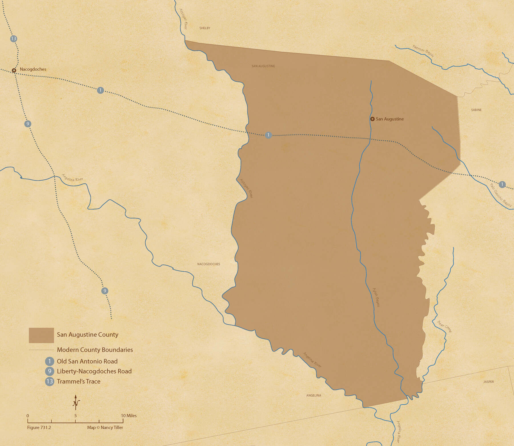
The Republic County of San Augustine. December 29, 1845
Figure No. 731.2 from 'A Boundary Atlas of Texas, 1821-1845' by Jim Tiller
-
Map/Doc
96272
-
Collection
Nancy and Jim Tiller Digital Collection
-
Object Dates
2020/1/1 (Creation Date)
-
People and Organizations
Jim Tiller (Author)
Nancy Tiller (Cartographer)
Gang Gong (GIS Professional)
-
Counties
San Augustine
-
Subjects
Atlas County Republic of Texas Texas Boundaries
-
Height x Width
18.8 x 21.7 inches
47.8 x 55.1 cm
-
Medium
digital image
-
Comments
To purchase a digital PDF copy of "A Boundary Atlas of Texas, 1821-1845" see 96437.
Part of: Nancy and Jim Tiller Digital Collection
The Republic County of Fannin. Created, December 14, 1837

Print $20.00
The Republic County of Fannin. Created, December 14, 1837
2020
Size 15.0 x 21.7 inches
Map/Doc 96128
The Mexican Department of Nacogdoches. On the Eve of Texas Independence, 1836

Print $20.00
The Mexican Department of Nacogdoches. On the Eve of Texas Independence, 1836
2020
Size 18.4 x 21.7 inches
Map/Doc 95974
The Chief Justice County of Victoria. September 20, 1837

Print $20.00
The Chief Justice County of Victoria. September 20, 1837
2020
Size 23.3 x 21.7 inches
Map/Doc 96075
The Republic County of Washington. January 29, 1842

Print $20.00
The Republic County of Washington. January 29, 1842
2020
Size 11.8 x 21.7 inches
Map/Doc 96307
The Republic County of Jefferson. December 29, 1845

Print $20.00
The Republic County of Jefferson. December 29, 1845
2020
Size 22.6 x 21.7 inches
Map/Doc 96201
The Mexican Municipality of Austin. Proposed, No Date

Print $20.00
The Mexican Municipality of Austin. Proposed, No Date
2020
Size 17.0 x 21.7 inches
Map/Doc 96014
The Judicial District/County of Lavaca. Abolished, Spring 1842

Print $20.00
The Judicial District/County of Lavaca. Abolished, Spring 1842
2020
Size 14.6 x 21.7 inches
Map/Doc 96332
Republic Counties. January 1, 1842

Print $20.00
Republic Counties. January 1, 1842
2020
Size 24.5 x 21.7 inches
Map/Doc 96315
The Republic County of Houston. December 29, 1845

Print $20.00
The Republic County of Houston. December 29, 1845
2020
Size 19.7 x 21.8 inches
Map/Doc 96183
The Mexican Municipality of Mina. Created, April 1834

Print $20.00
The Mexican Municipality of Mina. Created, April 1834
2020
Size 10.7 x 21.7 inches
Map/Doc 96028
The Republic County of Brazoria. December 29, 1845

Print $20.00
The Republic County of Brazoria. December 29, 1845
2020
Size 14.7 x 21.8 inches
Map/Doc 96115
The Judicial District/County of Pashcal. Abolished, Spring 1842

Print $20.00
The Judicial District/County of Pashcal. Abolished, Spring 1842
2020
Size 15.0 x 21.7 inches
Map/Doc 96345
You may also like
Jim Hogg County Rolled Sketch F

Print $20.00
- Digital $50.00
Jim Hogg County Rolled Sketch F
1930
Size 24.5 x 28.9 inches
Map/Doc 6445
Borden County

Print $20.00
- Digital $50.00
Borden County
1892
Size 44.1 x 44.1 inches
Map/Doc 66717
Hutchinson County Working Sketch 11

Print $20.00
- Digital $50.00
Hutchinson County Working Sketch 11
1924
Size 20.4 x 29.4 inches
Map/Doc 66369
Culberson County Sketch File 37

Print $20.00
- Digital $50.00
Culberson County Sketch File 37
1961
Size 24.8 x 18.5 inches
Map/Doc 11273
Johnson County Working Sketch 22

Print $20.00
- Digital $50.00
Johnson County Working Sketch 22
1992
Size 14.6 x 18.1 inches
Map/Doc 66635
[Surveys on the Trinity River]
![342, [Surveys on the Trinity River], General Map Collection](https://historictexasmaps.com/wmedia_w700/maps/342.tif.jpg)
Print $2.00
- Digital $50.00
[Surveys on the Trinity River]
Size 6.6 x 4.6 inches
Map/Doc 342
Palo Pinto County Sketch File 24

Print $20.00
- Digital $50.00
Palo Pinto County Sketch File 24
Size 21.0 x 32.8 inches
Map/Doc 12136
Pecos County Working Sketch 67

Print $20.00
- Digital $50.00
Pecos County Working Sketch 67
1955
Size 17.7 x 18.7 inches
Map/Doc 71539
Flight Mission No. CUG-3P, Frame 78, Kleberg County

Print $20.00
- Digital $50.00
Flight Mission No. CUG-3P, Frame 78, Kleberg County
1956
Size 18.5 x 22.2 inches
Map/Doc 86253
Map of The Surveyed Part of Peters Colony Texas

Print $40.00
- Digital $50.00
Map of The Surveyed Part of Peters Colony Texas
1854
Size 53.1 x 33.9 inches
Map/Doc 83008
Wise County Working Sketch 21

Print $20.00
- Digital $50.00
Wise County Working Sketch 21
1980
Size 25.9 x 32.4 inches
Map/Doc 72635
Map of the Straits of Florida and Gulf of Mexico

Print $20.00
- Digital $50.00
Map of the Straits of Florida and Gulf of Mexico
1851
Size 18.3 x 27.5 inches
Map/Doc 72676