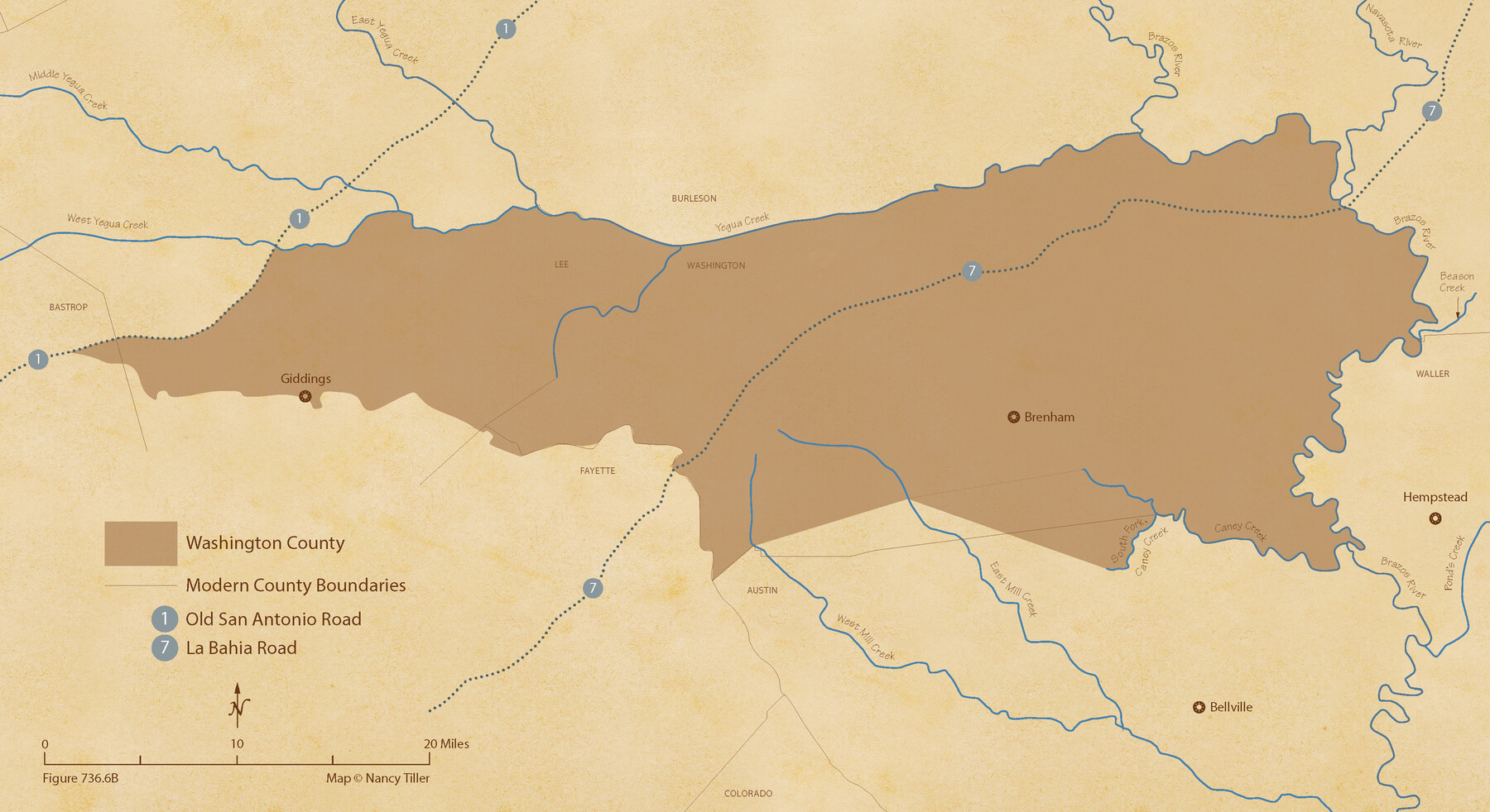
The Republic County of Washington. January 29, 1842
Figure No. 736.6 from 'A Boundary Atlas of Texas, 1821-1845' by Jim Tiller
-
Map/Doc
96307
-
Collection
Nancy and Jim Tiller Digital Collection
-
Object Dates
2020/1/1 (Creation Date)
-
People and Organizations
Jim Tiller (Author)
Nancy Tiller (Cartographer)
Gang Gong (GIS Professional)
-
Counties
Washington
-
Subjects
Atlas County Republic of Texas Texas Boundaries
-
Height x Width
11.8 x 21.7 inches
30.0 x 55.1 cm
-
Medium
digital image
-
Comments
To purchase a digital PDF copy of "A Boundary Atlas of Texas, 1821-1845" see 96437.
Part of: Nancy and Jim Tiller Digital Collection
The Republic County of Nacogdoches. December 29, 1845

Print $20.00
The Republic County of Nacogdoches. December 29, 1845
2020
Size 15.9 x 21.8 inches
Map/Doc 96250
The Republic County of Jackson. Spring 1842

Print $20.00
The Republic County of Jackson. Spring 1842
2020
Size 15.6 x 21.8 inches
Map/Doc 96190
The Republic County of Matagorda. December 24, 1844

Print $20.00
The Republic County of Matagorda. December 24, 1844
2020
Size 21.0 x 21.7 inches
Map/Doc 96223
The Castro Colony. February 15, 1842

Print $20.00
The Castro Colony. February 15, 1842
2020
Size 23.0 x 17.7 inches
Map/Doc 96357
The Republic County of Bexar. Spring 1842

Print $20.00
The Republic County of Bexar. Spring 1842
2020
Size 14.7 x 21.7 inches
Map/Doc 96100
The Republic County of Austin. February 5, 1840

Print $20.00
The Republic County of Austin. February 5, 1840
2020
Size 14.7 x 21.7 inches
Map/Doc 96084
The Republic County of Milam. January 29, 1842

Print $20.00
The Republic County of Milam. January 29, 1842
2020
Size 17.4 x 21.6 inches
Map/Doc 96231
The Republic County of Bowie. Created, December 17, 1840

Print $20.00
The Republic County of Bowie. Created, December 17, 1840
2020
Size 19.5 x 21.7 inches
Map/Doc 96102
The Republic County of Colorado. January 1, 1838

Print $20.00
The Republic County of Colorado. January 1, 1838
2020
Size 18.4 x 21.7 inches
Map/Doc 96120
From Citizens Living in Washington County for the Creation of a New County to be Called Washington, Undated

Print $20.00
From Citizens Living in Washington County for the Creation of a New County to be Called Washington, Undated
2020
Size 17.0 x 21.7 inches
Map/Doc 96406
The Mexican Municipality of Matagorda. December 5, 1835

Print $20.00
The Mexican Municipality of Matagorda. December 5, 1835
2020
Size 15.9 x 21.7 inches
Map/Doc 96027
Padilla and Chambers Empresario Colony. February 12, 1830

Print $20.00
Padilla and Chambers Empresario Colony. February 12, 1830
2020
Size 14.7 x 21.7 inches
Map/Doc 96002
You may also like
Crane County Working Sketch 28

Print $40.00
- Digital $50.00
Crane County Working Sketch 28
1972
Size 49.4 x 49.1 inches
Map/Doc 68305
Map of the United States and their Territories between the Mississippi and the Pacific Ocean and part of Mexico

Print $20.00
- Digital $50.00
Map of the United States and their Territories between the Mississippi and the Pacific Ocean and part of Mexico
1858
Size 23.5 x 26.5 inches
Map/Doc 96526
Map of Surveys in Oldham County

Print $20.00
- Digital $50.00
Map of Surveys in Oldham County
1903
Size 12.5 x 17.0 inches
Map/Doc 91449
[North Line of Kent County/South Line of Dickens County]
![90937, [North Line of Kent County/South Line of Dickens County], Twichell Survey Records](https://historictexasmaps.com/wmedia_w700/maps/90937-1.tif.jpg)
Print $20.00
- Digital $50.00
[North Line of Kent County/South Line of Dickens County]
1892
Size 8.4 x 38.1 inches
Map/Doc 90937
Flight Mission No. DIX-7P, Frame 13, Aransas County

Print $20.00
- Digital $50.00
Flight Mission No. DIX-7P, Frame 13, Aransas County
1956
Size 4.0 x 5.0 inches
Map/Doc 83865
Ector County Working Sketch 23

Print $40.00
- Digital $50.00
Ector County Working Sketch 23
1961
Size 55.9 x 43.3 inches
Map/Doc 68866
Aransas Pass to Baffin Bay

Print $20.00
- Digital $50.00
Aransas Pass to Baffin Bay
1938
Size 41.6 x 34.5 inches
Map/Doc 73411
Chambers County Sketch File 18b

Print $15.00
- Digital $50.00
Chambers County Sketch File 18b
1901
Size 9.2 x 8.1 inches
Map/Doc 17571
Matagorda County Rolled Sketch PHL

Print $20.00
- Digital $50.00
Matagorda County Rolled Sketch PHL
1937
Size 37.3 x 40.0 inches
Map/Doc 9476
Gulf Intracoastal Waterway - Aransas Bay to Corpus Christi Bay - Modified Route Main Channel

Print $20.00
- Digital $50.00
Gulf Intracoastal Waterway - Aransas Bay to Corpus Christi Bay - Modified Route Main Channel
1960
Size 31.0 x 42.7 inches
Map/Doc 61901
Profile of Proposed Water Line From SW. Public Service Co. Plant to Frontier Chemical Co. Plant, Sections 890 & 891, in Block D

Print $20.00
- Digital $50.00
Profile of Proposed Water Line From SW. Public Service Co. Plant to Frontier Chemical Co. Plant, Sections 890 & 891, in Block D
1957
Size 34.5 x 23.0 inches
Map/Doc 92444
