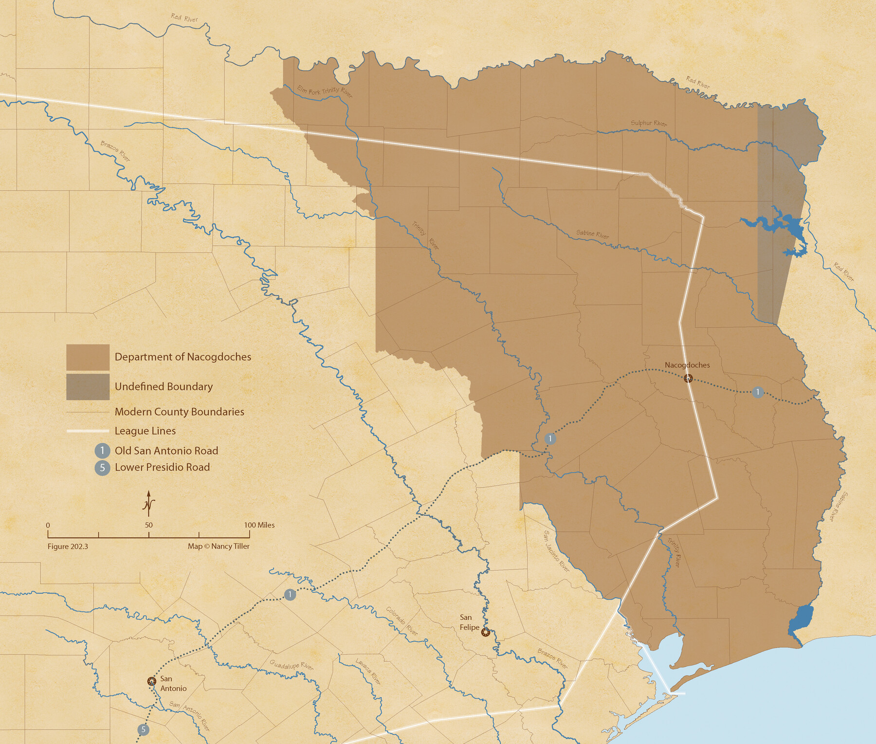
The Mexican Department of Nacogdoches. On the Eve of Texas Independence, 1836
Figure No. 202.3 from 'A Boundary Atlas of Texas, 1821-1845' by Jim Tiller
-
Map/Doc
95974
-
Collection
Nancy and Jim Tiller Digital Collection
-
Object Dates
2020/1/1 (Creation Date)
-
People and Organizations
Jim Tiller (Author)
Nancy Tiller (Cartographer)
Gang Gong (GIS Professional)
-
Subjects
Atlas Mexican Texas Texas Boundaries
-
Height x Width
18.4 x 21.7 inches
46.7 x 55.1 cm
-
Medium
digital image
-
Comments
To purchase a digital PDF copy of "A Boundary Atlas of Texas, 1821-1845" see 96437.
Part of: Nancy and Jim Tiller Digital Collection
The Republic County of Jasper. January 29, 1842

Print $20.00
The Republic County of Jasper. January 29, 1842
2020
Size 19.5 x 21.7 inches
Map/Doc 96194
The Mexican Municipality of Harrisburg. Defined, January 4, 1836

Print $20.00
The Mexican Municipality of Harrisburg. Defined, January 4, 1836
2020
Size 18.4 x 21.7 inches
Map/Doc 96022
From Citizens of Nacogdoches County for the Creation of a New County to be Called Smith, September 4, 1841

Print $20.00
From Citizens of Nacogdoches County for the Creation of a New County to be Called Smith, September 4, 1841
2020
Size 18.3 x 21.7 inches
Map/Doc 96392
The Mexican Department of Nacogdoches. May 6, 1833

Print $20.00
The Mexican Department of Nacogdoches. May 6, 1833
2020
Size 18.5 x 21.7 inches
Map/Doc 95973
The Chief Justice County of Milam. Lands in Conflict with Bexar County

Print $20.00
The Chief Justice County of Milam. Lands in Conflict with Bexar County
2020
Size 16.8 x 21.7 inches
Map/Doc 96060
From Citizens of Montgomery County to Redefine the Boundary Between Harris and Montgomery Counties, May 8, 1838

Print $20.00
From Citizens of Montgomery County to Redefine the Boundary Between Harris and Montgomery Counties, May 8, 1838
2020
Size 15.4 x 21.7 inches
Map/Doc 96382
From Citizens of Colorado and Matagorda Counties for the Creation of a New County (Unnamed), August 6, 1840

Print $20.00
From Citizens of Colorado and Matagorda Counties for the Creation of a New County (Unnamed), August 6, 1840
2020
Size 18.5 x 21.7 inches
Map/Doc 96389
The Republic County of Colorado. January 19, 1841

Print $20.00
The Republic County of Colorado. January 19, 1841
2020
Size 18.4 x 21.7 inches
Map/Doc 96124
The Republic County of Goliad. Boundaries Defined, December 2, 1841

Print $20.00
The Republic County of Goliad. Boundaries Defined, December 2, 1841
2020
Size 17.5 x 21.7 inches
Map/Doc 96151
The Judicial District/County of Spring Creek. Abolished, Spring 1842

Print $20.00
The Judicial District/County of Spring Creek. Abolished, Spring 1842
2020
Size 15.7 x 21.7 inches
Map/Doc 96349
From Citizens Living in Red River County for the Creation of a New County (Unnamed), Undated

Print $20.00
From Citizens Living in Red River County for the Creation of a New County (Unnamed), Undated
2020
Size 16.6 x 21.7 inches
Map/Doc 96405
The Republic County of Goliad. December 31, 1838

Print $20.00
The Republic County of Goliad. December 31, 1838
2020
Size 15.1 x 21.7 inches
Map/Doc 96149
You may also like
K&E Leroy Lettering Set - 3240

K&E Leroy Lettering Set - 3240
1950
Size 1.8 x 15.8 inches
Map/Doc 97313
Harrison County

Print $20.00
- Digital $50.00
Harrison County
1920
Size 42.8 x 39.8 inches
Map/Doc 73173
Sutton County Boundary File 5a

Print $20.00
- Digital $50.00
Sutton County Boundary File 5a
Size 14.5 x 8.9 inches
Map/Doc 59060
Mason County Sketch File 3a

Print $4.00
- Digital $50.00
Mason County Sketch File 3a
1877
Size 8.3 x 7.9 inches
Map/Doc 30682
Robertson County Working Sketch Graphic Index

Print $20.00
- Digital $50.00
Robertson County Working Sketch Graphic Index
1945
Size 46.8 x 37.9 inches
Map/Doc 76685
Plat of a survey on Padre Island in Cameron County surveyed for South Padre Development Corporation by Claunch and Associates

Print $40.00
- Digital $50.00
Plat of a survey on Padre Island in Cameron County surveyed for South Padre Development Corporation by Claunch and Associates
1970
Size 61.8 x 40.0 inches
Map/Doc 61429
Navarro County Working Sketch 16

Print $20.00
- Digital $50.00
Navarro County Working Sketch 16
1993
Size 15.8 x 17.7 inches
Map/Doc 71246
Map of Franklin County

Print $20.00
- Digital $50.00
Map of Franklin County
1879
Size 21.1 x 10.4 inches
Map/Doc 3560
Flight Mission No. CLL-1N, Frame 194, Willacy County

Print $20.00
- Digital $50.00
Flight Mission No. CLL-1N, Frame 194, Willacy County
1954
Size 18.5 x 22.1 inches
Map/Doc 87064
Lamb County Sketch File 16

Print $4.00
- Digital $50.00
Lamb County Sketch File 16
1929
Size 11.2 x 8.8 inches
Map/Doc 29379
[Blocks M18, M23, I, Z, and Block 47, Sections 16 - 28]
![91175, [Blocks M18, M23, I, Z, and Block 47, Sections 16 - 28], Twichell Survey Records](https://historictexasmaps.com/wmedia_w700/maps/91175-1.tif.jpg)
Print $20.00
- Digital $50.00
[Blocks M18, M23, I, Z, and Block 47, Sections 16 - 28]
Size 18.9 x 24.3 inches
Map/Doc 91175
The Republic County of Jackson. Boundaries Defined, December 29, 1837

Print $20.00
The Republic County of Jackson. Boundaries Defined, December 29, 1837
2020
Size 15.6 x 21.8 inches
Map/Doc 96184