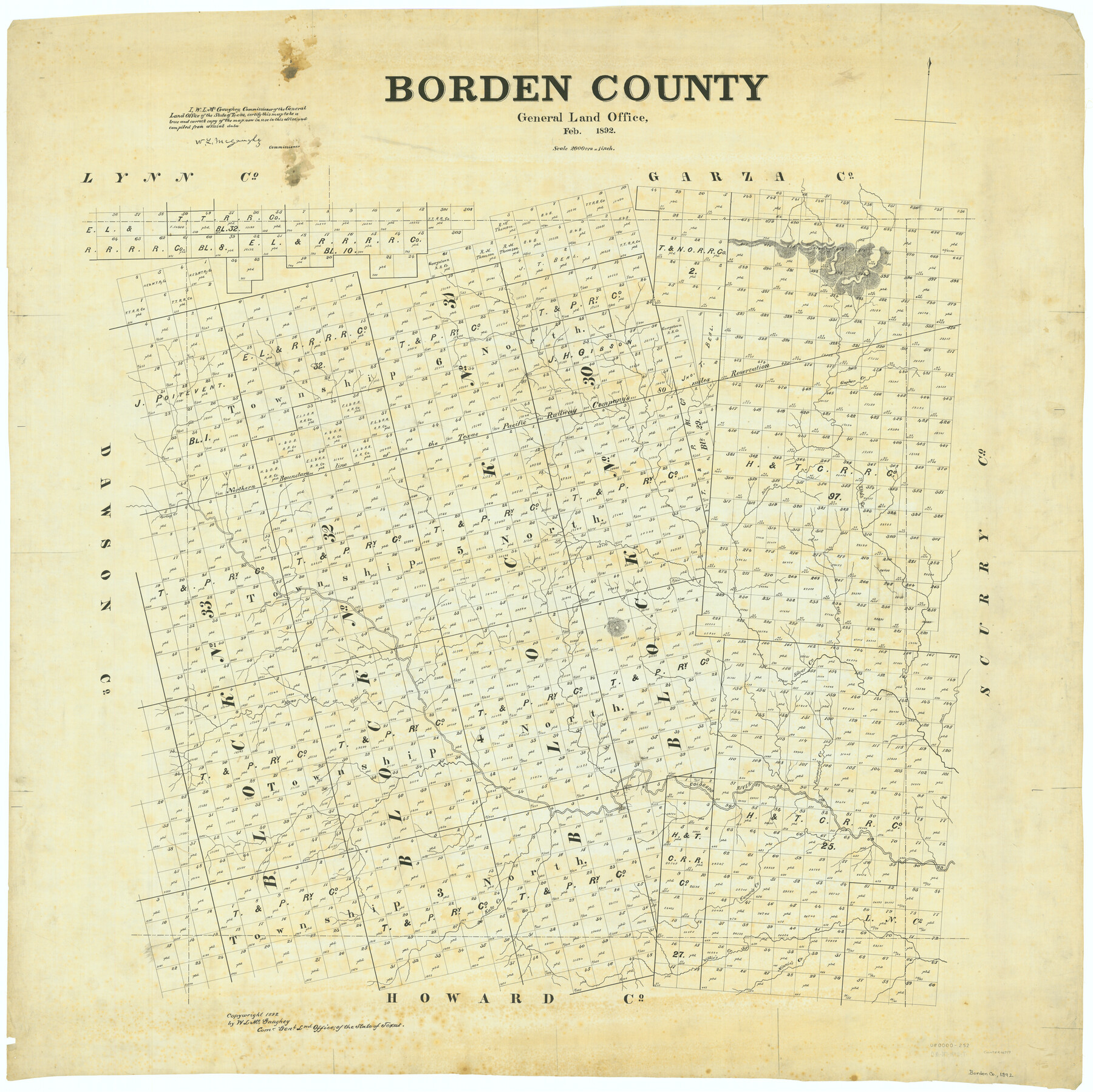
Borden County
-
Map/Doc
66717
-
Collection
General Map Collection
-
Object Dates
1892 (Creation Date)
-
People and Organizations
Texas General Land Office (Publisher)
W.L. McGaughey (GLO Commissioner)
-
Counties
Borden
-
Subjects
County
-
Height x Width
44.1 x 44.1 inches
112.0 x 112.0 cm
-
Comments
Copyrighted 1892.
Part of: General Map Collection
Anderson County Boundary File 9

Print $40.00
- Digital $50.00
Anderson County Boundary File 9
Size 19.7 x 58.3 inches
Map/Doc 49758
Sketch exhibiting inland channel from Saluria to Corpus Christi traced from a copy of a map belonging to U. S. Engr. Dept.

Print $20.00
- Digital $50.00
Sketch exhibiting inland channel from Saluria to Corpus Christi traced from a copy of a map belonging to U. S. Engr. Dept.
1853
Size 18.3 x 28.3 inches
Map/Doc 73007
Concho County Rolled Sketch 18

Print $20.00
- Digital $50.00
Concho County Rolled Sketch 18
1955
Size 11.4 x 18.3 inches
Map/Doc 5553
Mason County Working Sketch 7

Print $20.00
- Digital $50.00
Mason County Working Sketch 7
1945
Size 35.8 x 43.9 inches
Map/Doc 70843
Orange County Sketch File 31

Print $20.00
- Digital $50.00
Orange County Sketch File 31
1926
Size 17.9 x 20.0 inches
Map/Doc 12125
Lampasas County Rolled Sketch 6

Print $20.00
- Digital $50.00
Lampasas County Rolled Sketch 6
2014
Size 29.1 x 21.9 inches
Map/Doc 93775
Bexar County Sketch File 36a

Print $10.00
- Digital $50.00
Bexar County Sketch File 36a
1873
Size 11.3 x 8.8 inches
Map/Doc 14507
Austin County Sketch File EF

Print $40.00
- Digital $50.00
Austin County Sketch File EF
1895
Size 15.1 x 17.0 inches
Map/Doc 10879
Comanche County Working Sketch 19

Print $20.00
- Digital $50.00
Comanche County Working Sketch 19
1973
Size 28.9 x 40.3 inches
Map/Doc 68153
Hill County Sketch File 9

Print $4.00
- Digital $50.00
Hill County Sketch File 9
1857
Size 8.3 x 10.3 inches
Map/Doc 26476
Edwards County Sketch File 35a

Print $20.00
- Digital $50.00
Edwards County Sketch File 35a
1928
Size 33.0 x 23.5 inches
Map/Doc 11435
King County Rolled Sketch 13

Print $40.00
- Digital $50.00
King County Rolled Sketch 13
Size 50.5 x 29.3 inches
Map/Doc 9353
You may also like
[Sketch for Mineral Application 13440]
![65674, [Sketch for Mineral Application 13440], General Map Collection](https://historictexasmaps.com/wmedia_w700/maps/65674-1.tif.jpg)
Print $40.00
- Digital $50.00
[Sketch for Mineral Application 13440]
Size 65.8 x 42.9 inches
Map/Doc 65674
Williamson County Sketch File 30

Print $20.00
- Digital $50.00
Williamson County Sketch File 30
Size 24.6 x 18.7 inches
Map/Doc 12696
Trinity River, White Rock Reservoir Sheet/White Rock Creek

Print $6.00
- Digital $50.00
Trinity River, White Rock Reservoir Sheet/White Rock Creek
1923
Size 36.3 x 16.7 inches
Map/Doc 65213
Reeves County Rolled Sketch 40

Print $20.00
- Digital $50.00
Reeves County Rolled Sketch 40
2019
Size 18.1 x 24.2 inches
Map/Doc 95826
Flight Mission No. DCL-7C, Frame 19, Kenedy County

Print $20.00
- Digital $50.00
Flight Mission No. DCL-7C, Frame 19, Kenedy County
1943
Size 15.4 x 15.2 inches
Map/Doc 86011
General Highway Map, Montgomery County, Texas

Print $20.00
General Highway Map, Montgomery County, Texas
1939
Size 18.4 x 24.6 inches
Map/Doc 79202
La Salle County Rolled Sketch 25

Print $20.00
- Digital $50.00
La Salle County Rolled Sketch 25
Size 20.3 x 24.4 inches
Map/Doc 6586
Edwards County Sketch File 52

Print $20.00
- Digital $50.00
Edwards County Sketch File 52
1972
Size 19.9 x 35.1 inches
Map/Doc 11446

Hays County Working Sketch 11

Print $20.00
- Digital $50.00
Hays County Working Sketch 11
1950
Size 22.7 x 33.1 inches
Map/Doc 66085
Map of Copano, St. Charles, Aransas & Red Fish Bays in Aransas & Nueces Counties showing subdivision thereof for Mineral Development

Print $20.00
- Digital $50.00
Map of Copano, St. Charles, Aransas & Red Fish Bays in Aransas & Nueces Counties showing subdivision thereof for Mineral Development
1948
Size 35.9 x 34.0 inches
Map/Doc 2923
[Photostats of section of Hydrographic Surveys H-5399, H-4822 and H-470, Mouth of Trinity River]
![61154, [Photostats of section of Hydrographic Surveys H-5399, H-4822 and H-470, Mouth of Trinity River], General Map Collection](https://historictexasmaps.com/wmedia_w700/maps/61154.tif.jpg)
Print $20.00
- Digital $50.00
[Photostats of section of Hydrographic Surveys H-5399, H-4822 and H-470, Mouth of Trinity River]
1933
Size 18.2 x 25.8 inches
Map/Doc 61154