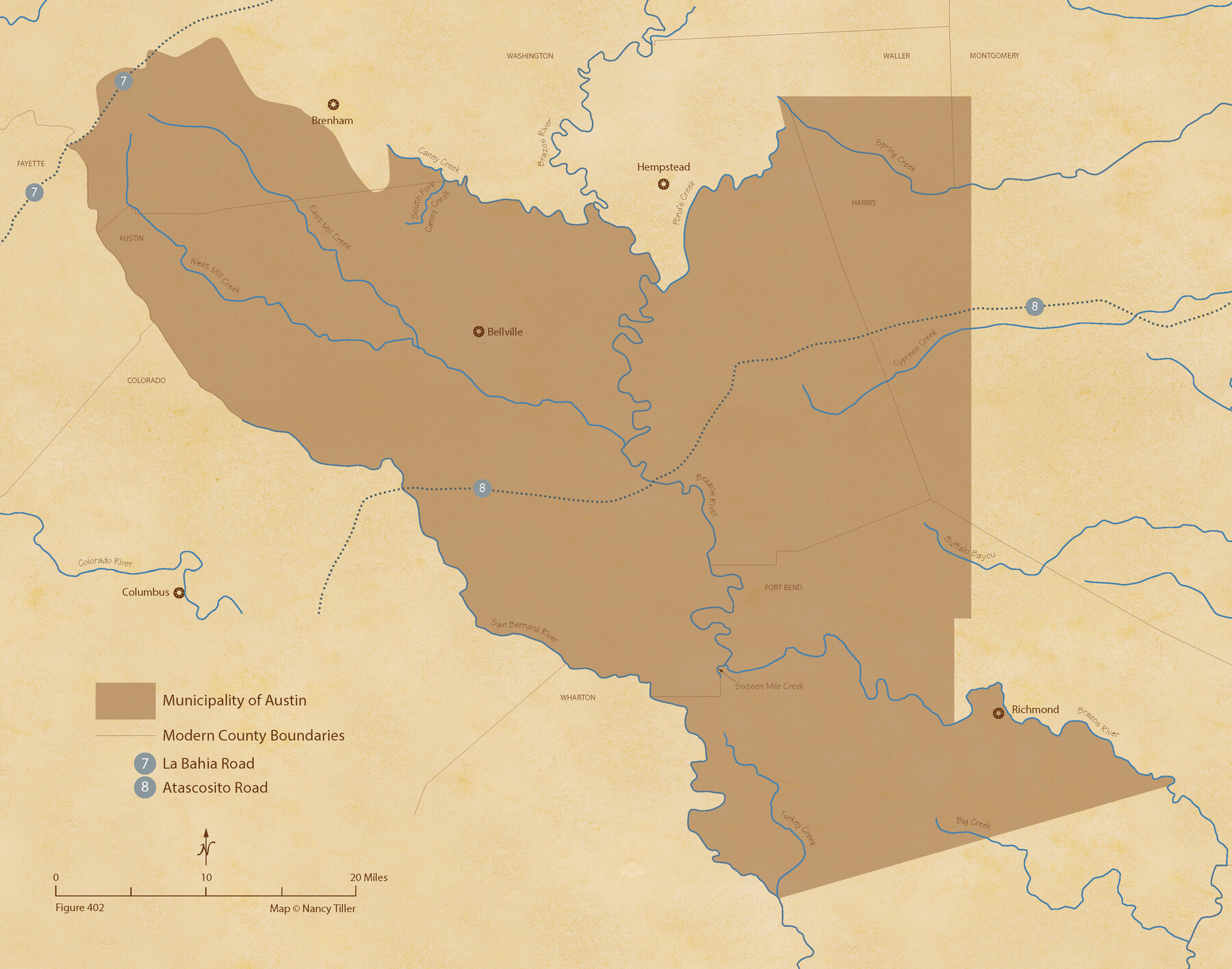
The Mexican Municipality of Austin. Proposed, No Date
Figure No. 402 from 'A Boundary Atlas of Texas, 1821-1845' by Jim Tiller
-
Map/Doc
96014
-
Collection
Nancy and Jim Tiller Digital Collection
-
Object Dates
2020/1/1 (Creation Date)
-
People and Organizations
Jim Tiller (Author)
Nancy Tiller (Cartographer)
Gang Gong (GIS Professional)
-
Subjects
Atlas Mexican Texas Texas Boundaries
-
Height x Width
17.0 x 21.7 inches
43.2 x 55.1 cm
-
Medium
digital image
-
Comments
To purchase a digital PDF copy of "A Boundary Atlas of Texas, 1821-1845" see 96437.
Part of: Nancy and Jim Tiller Digital Collection
Leftwich Empresario Colony. April 15, 1825

Print $20.00
Leftwich Empresario Colony. April 15, 1825
2020
Size 19.5 x 21.7 inches
Map/Doc 95997
The Republic County of Bexar. November 28, 1839

Print $20.00
The Republic County of Bexar. November 28, 1839
2020
Size 14.8 x 21.1 inches
Map/Doc 96097
The Republic County of Montgomery. December 18, 1837

Print $20.00
The Republic County of Montgomery. December 18, 1837
2020
Size 19.9 x 21.7 inches
Map/Doc 96235
The Chief Justice County of Harrisburg. Lands in Conflict with Brazoria, Liberty Counties

Print $20.00
The Chief Justice County of Harrisburg. Lands in Conflict with Brazoria, Liberty Counties
2020
Size 17.5 x 21.7 inches
Map/Doc 96050
The Republic County of Bowie. January 8, 1844

Print $20.00
The Republic County of Bowie. January 8, 1844
2020
Size 19.5 x 21.7 inches
Map/Doc 96107
The Mexican Municipalities. On the Eve of Texas Independence, 1836

Print $20.00
The Mexican Municipalities. On the Eve of Texas Independence, 1836
2020
Size 17.2 x 21.6 inches
Map/Doc 96013
From Citizens of Liberty County for the Creation a New County to be Called Crockett, November 12, 1838

Print $20.00
From Citizens of Liberty County for the Creation a New County to be Called Crockett, November 12, 1838
2020
Size 22.3 x 21.7 inches
Map/Doc 96385
The Judicial District/County of Menard. Abolished, Spring 1842

Print $20.00
The Judicial District/County of Menard. Abolished, Spring 1842
2020
Size 22.4 x 21.7 inches
Map/Doc 96337
The Judicial District/County of Spring Creek. Created, January 21, 1841

Print $20.00
The Judicial District/County of Spring Creek. Created, January 21, 1841
2020
Size 15.7 x 21.7 inches
Map/Doc 96348
The Republic County of Lamar. Spring 1842

Print $20.00
The Republic County of Lamar. Spring 1842
2020
Size 16.4 x 21.7 inches
Map/Doc 96204
The Republic County of Jackson. Boundaries Defined, December 29, 1837

Print $20.00
The Republic County of Jackson. Boundaries Defined, December 29, 1837
2020
Size 15.6 x 21.8 inches
Map/Doc 96184
The Republic County of Bastrop. Boundaries Defined, December 18, 1837

Print $20.00
The Republic County of Bastrop. Boundaries Defined, December 18, 1837
2020
Size 14.7 x 21.7 inches
Map/Doc 96089
You may also like
Liberty County Working Sketch 6

Print $20.00
- Digital $50.00
Liberty County Working Sketch 6
1903
Size 17.2 x 19.5 inches
Map/Doc 70465
Supreme Court of the United States, October Term, 1923, No. 15, Original - The State of Oklahoma, Complainant vs. The State of Texas, Defendant, The United States, Intervener; Report of the Boundary Commissioners

Print $20.00
- Digital $50.00
Supreme Court of the United States, October Term, 1923, No. 15, Original - The State of Oklahoma, Complainant vs. The State of Texas, Defendant, The United States, Intervener; Report of the Boundary Commissioners
1923
Size 25.0 x 37.8 inches
Map/Doc 75121
Nolan County Sketch File B

Print $20.00
- Digital $50.00
Nolan County Sketch File B
1902
Size 12.0 x 21.5 inches
Map/Doc 42171

Anderson County Working Sketch 15

Print $20.00
- Digital $50.00
Anderson County Working Sketch 15
1937
Size 19.7 x 22.7 inches
Map/Doc 67015
San Patricio County Rolled Sketch 45

Print $20.00
- Digital $50.00
San Patricio County Rolled Sketch 45
1979
Size 24.0 x 33.5 inches
Map/Doc 7729
Duval County Sketch File 73

Print $4.00
- Digital $50.00
Duval County Sketch File 73
Size 9.9 x 8.8 inches
Map/Doc 21463
McClennan County Robertson District East of the Brazos Milam District West of the Brazos

Print $20.00
- Digital $50.00
McClennan County Robertson District East of the Brazos Milam District West of the Brazos
1878
Size 21.0 x 23.4 inches
Map/Doc 3865
Nueces County Rolled Sketch 100

Print $20.00
- Digital $50.00
Nueces County Rolled Sketch 100
Size 43.9 x 37.7 inches
Map/Doc 10208
Schleicher County Sketch File 5

Print $40.00
- Digital $50.00
Schleicher County Sketch File 5
Size 17.2 x 13.4 inches
Map/Doc 36470
Flight Mission No. CRC-2R, Frame 181, Chambers County

Print $20.00
- Digital $50.00
Flight Mission No. CRC-2R, Frame 181, Chambers County
1956
Size 18.7 x 22.4 inches
Map/Doc 84759
Wise County Sketch File 30

Print $6.00
- Digital $50.00
Wise County Sketch File 30
1876
Size 12.7 x 8.1 inches
Map/Doc 40579