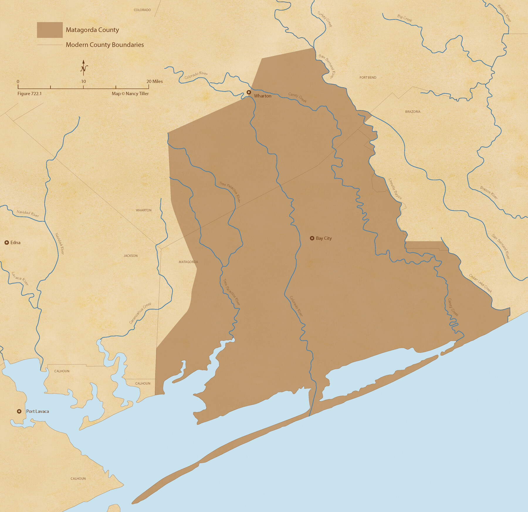
The Republic County of Matagorda. Proposed, Late Fall 1837
Figure No. 722.1 from 'A Boundary Atlas of Texas, 1821-1845' by Jim Tiller
- 
                          Map/Doc
96214
 - 
                            Collection
Nancy and Jim Tiller Digital Collection
 - 
                            Object Dates
2020/1/1 (Creation Date)
 - 
                            People and Organizations
Jim Tiller (Author)
Nancy Tiller (Cartographer)
Gang Gong (GIS Professional)
 - 
                            Counties
Matagorda
 - 
                            Subjects
Atlas County Republic of Texas Texas Boundaries
 - 
                            Height x Width
21.0 x 21.7 inches
53.3 x 55.1 cm
 - 
                            Medium
digital image
 - 
                            Comments
To purchase a digital PDF copy of "A Boundary Atlas of Texas, 1821-1845" see 96437.
 
Part of: Nancy and Jim Tiller Digital Collection
            The Republic County of Fayette. May 3, 1838


                                            Print $20.00                    
                                    
                The Republic County of Fayette. May 3, 1838
2020
Size 14.7 x 21.7 inches
                                Map/Doc 96132
            
            Austin Empresario Colony. January 17, 1821/February 18, 1823


                                            Print $20.00                    
                                    
                Austin Empresario Colony. January 17, 1821/February 18, 1823
2020
Size 18.8 x 21.6 inches
                                Map/Doc 95978
            
            The Republic County of Matagorda. January 1, 1838


                                            Print $20.00                    
                                    
                The Republic County of Matagorda. January 1, 1838
2020
Size 21.0 x 21.7 inches
                                Map/Doc 96216
            
            The Mexican Company Empresario Colony. May 1, 1832


                                            Print $20.00                    
                                    
                The Mexican Company Empresario Colony. May 1, 1832
2020
Size 15.0 x 21.7 inches
                                Map/Doc 95999
            
            The Land Offices. December 22, 1836


                                            Print $20.00                    
                                    
                The Land Offices. December 22, 1836
2020
Size 24.7 x 21.7 inches
                                Map/Doc 96425
            
            From Citizens of Washington County Living East of the Brazos River and in the Forks of the Navasota and Brazos Rivers and South of the Old San Antonio Road for the Creation of a New County (Unnamed), January 13, 1840


                                            Print $20.00                    
                                    
                From Citizens of Washington County Living East of the Brazos River and in the Forks of the Navasota and Brazos Rivers and South of the Old San Antonio Road for the Creation of a New County (Unnamed), January 13, 1840
2020
Size 20.4 x 21.7 inches
                                Map/Doc 96388
            
            Thorn Empresario Colony. April 25, 1825


                                            Print $20.00                    
                                    
                Thorn Empresario Colony. April 25, 1825
2020
Size 17.0 x 21.7 inches
                                Map/Doc 96006
            
            The Chief Justice County of Mina. Lands in Conflict with Colorado County


                                            Print $20.00                    
                                    
                The Chief Justice County of Mina. Lands in Conflict with Colorado County
2020
Size 15.8 x 21.7 inches
                                Map/Doc 96062
            
            The Republic County of Rusk. Created, January 16, 1843


                                            Print $20.00                    
                                    
                The Republic County of Rusk. Created, January 16, 1843
2020
Size 19.1 x 21.7 inches
                                Map/Doc 96265
            
            The Republic County of Liberty. January 22, 1841


                                            Print $20.00                    
                                    
                The Republic County of Liberty. January 22, 1841
2020
Size 19.9 x 21.7 inches
                                Map/Doc 96210
            
            The Republic County of Fayette. Created, December 14, 1837


                                            Print $20.00                    
                                    
                The Republic County of Fayette. Created, December 14, 1837
2020
Size 14.7 x 21.7 inches
                                Map/Doc 96131
            
            From Citizens of Fannin County for the Creation of a New County to be Called Sherman, December 1, 1845


                                            Print $20.00                    
                                    
                From Citizens of Fannin County for the Creation of a New County to be Called Sherman, December 1, 1845
2020
Size 16.7 x 21.7 inches
                                Map/Doc 96397
            You may also like
            Current Miscellaneous File 47


                                            Print $12.00                    
                                             -                         Digital $50.00                                    
                Current Miscellaneous File 47
1920
Size 16.3 x 9.2 inches
                                Map/Doc 73992
            
            Pocket Map of the State of Texas reduced from their original map of the State and drawn by Chas. W. Pressler and A. B. Langermann


                                            Print $20.00                    
                                    
                Pocket Map of the State of Texas reduced from their original map of the State and drawn by Chas. W. Pressler and A. B. Langermann
1879
Size 24.4 x 26.3 inches
                                Map/Doc 76208
            
            Bosque County Working Sketch 11


                                            Print $20.00                    
                                             -                         Digital $50.00                                    
                Bosque County Working Sketch 11
1952
Size 10.8 x 30.4 inches
                                Map/Doc 67444
            
            Pecos County Working Sketch 108


                                            Print $40.00                    
                                             -                         Digital $50.00                                    
                Pecos County Working Sketch 108
1971
Size 43.5 x 56.3 inches
                                Map/Doc 71581
            
            Nueces County Rolled Sketch 82


                                            Print $43.00                    
                                    
                Nueces County Rolled Sketch 82
1982
Size 18.6 x 25.0 inches
                                Map/Doc 6961
            
            Archer County Working Sketch Graphic Index


                                            Print $20.00                    
                                             -                         Digital $50.00                                    
                Archer County Working Sketch Graphic Index
1926
Size 46.7 x 39.4 inches
                                Map/Doc 76456
            
            Andrews County Working Sketch 23


                                            Print $20.00                    
                                             -                         Digital $50.00                                    
                Andrews County Working Sketch 23
1979
Size 26.6 x 27.7 inches
                                Map/Doc 67069
            
            Parker County Working Sketch 21


                                            Print $20.00                    
                                             -                         Digital $50.00                                    
                Parker County Working Sketch 21
2006
Map/Doc 83655
            
            Callahan County, Texas


                                            Print $20.00                    
                                             -                         Digital $50.00                                    
                Callahan County, Texas
1880
Size 24.1 x 18.5 inches
                                Map/Doc 89276
            
            Buenaventura Reyes Grants


                                            Print $20.00                    
                                             -                         Digital $50.00                                    
                Buenaventura Reyes Grants
1896
Size 14.9 x 13.5 inches
                                Map/Doc 2057
            
            Upshur County Working Sketch 14


                                            Print $20.00                    
                                             -                         Digital $50.00                                    
                Upshur County Working Sketch 14
1993
Size 23.1 x 37.1 inches
                                Map/Doc 69571