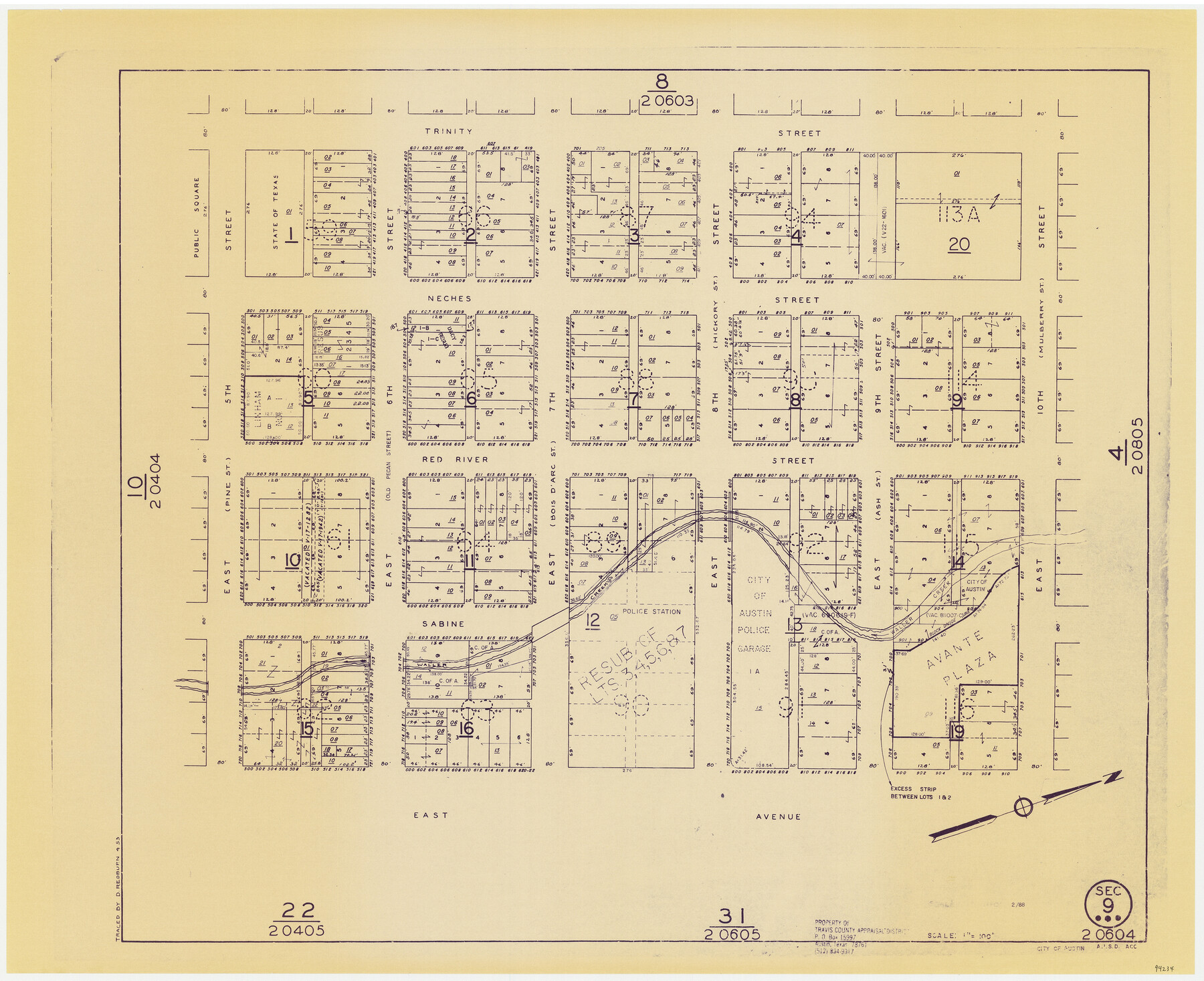
Travis County Appraisal District Plat Map 2_0604
Section 9
-
Map/Doc
94234
-
Collection
General Map Collection
-
Object Dates
1953 (Copy/Tracing Date)
1988 (Edition Date)
-
People and Organizations
Travis County Appraisal District (Publisher)
D. Redburn (Tracer)
-
Counties
Travis
-
Subjects
City
-
Height x Width
21.5 x 26.4 inches
54.6 x 67.1 cm
-
Medium
blueprint/diazo
-
Scale
1" = 100'
Part of: General Map Collection
Right of Way and Track Map, the Missouri, Kansas and Texas Ry. of Texas operated by the Missouri, Kansas and Texas Ry. of Texas, San Antonio Division

Print $40.00
- Digital $50.00
Right of Way and Track Map, the Missouri, Kansas and Texas Ry. of Texas operated by the Missouri, Kansas and Texas Ry. of Texas, San Antonio Division
1918
Size 25.2 x 58.8 inches
Map/Doc 64584
Jefferson County Working Sketch 7

Print $20.00
- Digital $50.00
Jefferson County Working Sketch 7
1931
Size 18.0 x 18.6 inches
Map/Doc 66550

Travis County Boundary File 25

Print $8.00
- Digital $50.00
Travis County Boundary File 25
Size 9.0 x 6.4 inches
Map/Doc 59459
Upton County Rolled Sketch 13

Print $20.00
- Digital $50.00
Upton County Rolled Sketch 13
1926
Size 32.5 x 43.6 inches
Map/Doc 10037
Flight Mission No. DQN-2K, Frame 41, Calhoun County

Print $20.00
- Digital $50.00
Flight Mission No. DQN-2K, Frame 41, Calhoun County
1953
Size 18.5 x 22.2 inches
Map/Doc 84246
Hill County Rolled Sketch 1

Print $20.00
- Digital $50.00
Hill County Rolled Sketch 1
1950
Size 13.1 x 41.0 inches
Map/Doc 6214
[Right of Way & Track Map, The Texas & Pacific Ry. Co. Main Line]
![64681, [Right of Way & Track Map, The Texas & Pacific Ry. Co. Main Line], General Map Collection](https://historictexasmaps.com/wmedia_w700/maps/64681.tif.jpg)
Print $20.00
- Digital $50.00
[Right of Way & Track Map, The Texas & Pacific Ry. Co. Main Line]
Size 11.0 x 19.0 inches
Map/Doc 64681
Flight Mission No. DAG-24K, Frame 40, Matagorda County

Print $20.00
- Digital $50.00
Flight Mission No. DAG-24K, Frame 40, Matagorda County
1953
Size 18.5 x 22.3 inches
Map/Doc 86527
Andrews County Working Sketch 34

Print $20.00
- Digital $50.00
Andrews County Working Sketch 34
1990
Size 29.9 x 31.0 inches
Map/Doc 67080
Orange County Sketch File 39

Print $20.00
- Digital $50.00
Orange County Sketch File 39
1964
Size 24.2 x 27.9 inches
Map/Doc 12127
Swisher County Sketch File 6

Print $20.00
- Digital $50.00
Swisher County Sketch File 6
Size 15.4 x 12.1 inches
Map/Doc 12404
You may also like
Hartley County Sketch File 13

Print $80.00
- Digital $50.00
Hartley County Sketch File 13
1924
Size 18.3 x 12.5 inches
Map/Doc 26106
Hunt County Sketch File 36a

Print $6.00
- Digital $50.00
Hunt County Sketch File 36a
Size 10.5 x 11.5 inches
Map/Doc 27153
Jack County Working Sketch 8

Print $20.00
- Digital $50.00
Jack County Working Sketch 8
1954
Size 30.5 x 35.9 inches
Map/Doc 66434
[Lgs. 180-183, 196-198, 105-112, 678-680, 699-701, 141-143]
![90155, [Lgs. 180-183, 196-198, 105-112, 678-680, 699-701, 141-143], Twichell Survey Records](https://historictexasmaps.com/wmedia_w700/maps/90155-1.tif.jpg)
Print $2.00
- Digital $50.00
[Lgs. 180-183, 196-198, 105-112, 678-680, 699-701, 141-143]
1913
Size 9.9 x 6.0 inches
Map/Doc 90155
Transcribed English Field Notes from Austin's Colonies and Transcribed Spanish Titles from Robertson's Colony, 1825-1835

Transcribed English Field Notes from Austin's Colonies and Transcribed Spanish Titles from Robertson's Colony, 1825-1835
1825
Size 17.0 x 12.1 inches
Map/Doc 94532
[Sketch showing C. D. & W. A. Murphy's Pasture and Wint Barfield's Pasture]
![90885, [Sketch showing C. D. & W. A. Murphy's Pasture and Wint Barfield's Pasture], Twichell Survey Records](https://historictexasmaps.com/wmedia_w700/maps/90885-1.tif.jpg)
Print $20.00
- Digital $50.00
[Sketch showing C. D. & W. A. Murphy's Pasture and Wint Barfield's Pasture]
Size 31.9 x 27.4 inches
Map/Doc 90885
Milam County Sketch File 9

Print $4.00
- Digital $50.00
Milam County Sketch File 9
1873
Size 12.8 x 8.2 inches
Map/Doc 31639
El Paso County Sketch File 29

Print $14.00
- Digital $50.00
El Paso County Sketch File 29
1949
Size 14.5 x 9.4 inches
Map/Doc 22076
Zavala County Sketch File 39

Print $4.00
- Digital $50.00
Zavala County Sketch File 39
1884
Size 14.4 x 8.7 inches
Map/Doc 41404
Flight Mission No. CRC-3R, Frame 11, Chambers County

Print $20.00
- Digital $50.00
Flight Mission No. CRC-3R, Frame 11, Chambers County
1956
Size 18.7 x 22.4 inches
Map/Doc 84785
Flight Mission No. DIX-6P, Frame 110, Aransas County

Print $20.00
- Digital $50.00
Flight Mission No. DIX-6P, Frame 110, Aransas County
1956
Size 19.7 x 23.4 inches
Map/Doc 83816
Map of Nolan County

Print $20.00
- Digital $50.00
Map of Nolan County
1902
Size 47.4 x 37.5 inches
Map/Doc 5021