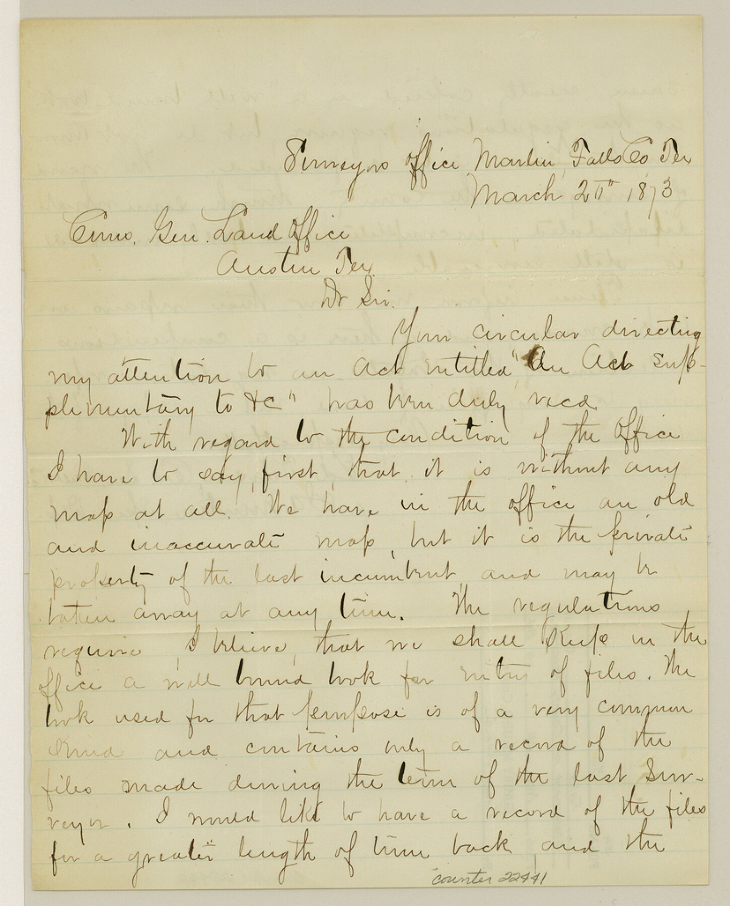
Falls County Sketch File 33
[Letter from county surveyor regarding county records]
-
Map/Doc
22441
-
Collection
General Map Collection
-
Object Dates
1873/3/21 (Creation Date)
1984/11/26 (File Date)
-
People and Organizations
Ed Pierson (Surveyor/Engineer)
-
Counties
Falls
-
Subjects
Surveying Sketch File
-
Height x Width
10.3 x 8.3 inches
26.2 x 21.1 cm
-
Medium
paper, manuscript
Part of: General Map Collection
Carte Reduite du Globe Terrestre

Print $20.00
- Digital $50.00
Carte Reduite du Globe Terrestre
1782
Size 13.5 x 17.1 inches
Map/Doc 97117
Gaines County Rolled Sketch 16

Print $40.00
- Digital $50.00
Gaines County Rolled Sketch 16
1940
Size 51.2 x 36.0 inches
Map/Doc 9039
Presidio County Sketch File 117

Print $26.00
- Digital $50.00
Presidio County Sketch File 117
1994
Size 14.3 x 8.8 inches
Map/Doc 34906
Carson County Boundary File 3

Print $2.00
- Digital $50.00
Carson County Boundary File 3
Size 13.3 x 8.3 inches
Map/Doc 51131
Travis County Rolled Sketch 18

Print $20.00
- Digital $50.00
Travis County Rolled Sketch 18
1940
Size 28.8 x 21.1 inches
Map/Doc 8020
Montgomery County Working Sketch 37

Print $20.00
- Digital $50.00
Montgomery County Working Sketch 37
1953
Size 24.5 x 33.8 inches
Map/Doc 71144
Val Verde County Sketch File 51a

Print $8.00
- Digital $50.00
Val Verde County Sketch File 51a
1959
Size 11.4 x 8.8 inches
Map/Doc 39325
Marion County Working Sketch 46

Print $20.00
- Digital $50.00
Marion County Working Sketch 46
2011
Size 21.4 x 29.1 inches
Map/Doc 90032
Austin County Working Sketch 3

Print $20.00
- Digital $50.00
Austin County Working Sketch 3
1950
Size 33.3 x 40.1 inches
Map/Doc 67244
Refugio County Boundary File 1 (3)

Print $22.00
- Digital $50.00
Refugio County Boundary File 1 (3)
Size 10.4 x 27.5 inches
Map/Doc 58231
Zavala County Sketch File 13

Print $4.00
- Digital $50.00
Zavala County Sketch File 13
1891
Size 14.5 x 9.0 inches
Map/Doc 41306
Map of the Lands Surveyed by the Memphis, El Paso & Pacific R.R. Company

Print $20.00
- Digital $50.00
Map of the Lands Surveyed by the Memphis, El Paso & Pacific R.R. Company
1859
Size 13.9 x 21.3 inches
Map/Doc 4849
You may also like
Bowie County Working Sketch 16

Print $20.00
- Digital $50.00
Bowie County Working Sketch 16
1961
Size 17.8 x 17.2 inches
Map/Doc 67420
Texas Intracoastal Waterway - Matagorda Bay, Cedar Lakes to Oyster Lake

Print $20.00
- Digital $50.00
Texas Intracoastal Waterway - Matagorda Bay, Cedar Lakes to Oyster Lake
1960
Size 27.1 x 38.9 inches
Map/Doc 73370
Bowie County Sketch File 7c

Print $7.00
- Digital $50.00
Bowie County Sketch File 7c
Size 11.9 x 7.4 inches
Map/Doc 14864
Nacogdoches County Sketch File 8

Print $20.00
- Digital $50.00
Nacogdoches County Sketch File 8
Size 20.8 x 28.7 inches
Map/Doc 42154
Nueces County NRC Article 33.136 Location Key Sheet

Print $20.00
- Digital $50.00
Nueces County NRC Article 33.136 Location Key Sheet
1975
Size 27.0 x 23.0 inches
Map/Doc 88586
Polk County Working Sketch 34

Print $20.00
- Digital $50.00
Polk County Working Sketch 34
1961
Size 41.3 x 42.0 inches
Map/Doc 71651
Flight Mission No. BQR-9K, Frame 45, Brazoria County

Print $20.00
- Digital $50.00
Flight Mission No. BQR-9K, Frame 45, Brazoria County
1952
Size 18.7 x 22.3 inches
Map/Doc 84049
Ownership Map NW 1/4 Lubbock County

Print $20.00
- Digital $50.00
Ownership Map NW 1/4 Lubbock County
1926
Size 32.1 x 39.6 inches
Map/Doc 89696
The Republic County of Jackson. December 29, 1845

Print $20.00
The Republic County of Jackson. December 29, 1845
2020
Size 15.6 x 21.8 inches
Map/Doc 96192
Brewster County Working Sketch 29

Print $20.00
- Digital $50.00
Brewster County Working Sketch 29
1941
Size 19.1 x 31.2 inches
Map/Doc 67563
The Republic County of Robertson. December 29, 1845

Print $20.00
The Republic County of Robertson. December 29, 1845
2020
Size 16.9 x 21.7 inches
Map/Doc 96264
Kinney County

Print $40.00
- Digital $50.00
Kinney County
1955
Size 51.9 x 48.2 inches
Map/Doc 95559