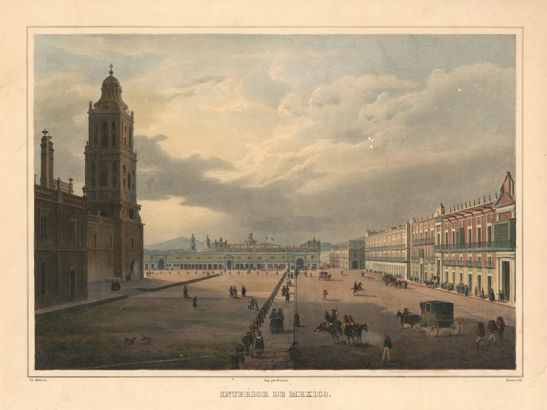
Interior de Mexico
[Zócalo]
-
Map/Doc
97350
-
Collection
General Map Collection
-
Object Dates
1836 (Creation Date)
-
People and Organizations
Carl Nebel (Illustrator)
-
Subjects
Mexico
-
Height x Width
13.5 x 18.0 inches
34.3 x 45.7 cm
-
Medium
lithograph
-
Comments
This illustration comes from the book: "Voyage pittoresque et archéologique dans la partie la plus intéressante du Méxique", published in Paris in 1836.
Part of: General Map Collection
State Prison System, Cherokee County

Print $20.00
- Digital $50.00
State Prison System, Cherokee County
Size 17.9 x 13.8 inches
Map/Doc 73561
Brazoria County Working Sketch 14

Print $20.00
- Digital $50.00
Brazoria County Working Sketch 14
1940
Size 33.6 x 43.9 inches
Map/Doc 67499
Flight Mission No. DAG-21K, Frame 86, Matagorda County

Print $20.00
- Digital $50.00
Flight Mission No. DAG-21K, Frame 86, Matagorda County
1952
Size 18.5 x 19.5 inches
Map/Doc 86415
PSL Field Notes for Blocks 1 and 2, Hansford and Sherman Counties, Blocks 3 and 4, Hansford County, Blocks A1, A2, A4, A5, and A6 in Hartley County, Block C0 in Hockley, Lubbock, Lynn, and Terry Counties, and Blocks A and B in Kent County

PSL Field Notes for Blocks 1 and 2, Hansford and Sherman Counties, Blocks 3 and 4, Hansford County, Blocks A1, A2, A4, A5, and A6 in Hartley County, Block C0 in Hockley, Lubbock, Lynn, and Terry Counties, and Blocks A and B in Kent County
Map/Doc 81655
Flight Mission No. DAH-9M, Frame 198, Orange County

Print $20.00
- Digital $50.00
Flight Mission No. DAH-9M, Frame 198, Orange County
1953
Size 18.6 x 22.5 inches
Map/Doc 86866
Map of Zapata County

Print $40.00
- Digital $50.00
Map of Zapata County
1901
Size 49.1 x 42.4 inches
Map/Doc 63144
Palo Pinto County Rolled Sketch 8

Print $40.00
- Digital $50.00
Palo Pinto County Rolled Sketch 8
Size 116.4 x 54.6 inches
Map/Doc 9674
Houston County Sketch File 40

Print $40.00
- Digital $50.00
Houston County Sketch File 40
Size 16.3 x 12.1 inches
Map/Doc 26826
Sectional Map No. 2 of the lands and the line of the Texas & Pacific Ry. Co. in Howard, Martin, Andrews, Midland and Tom Green Counties

Print $20.00
- Digital $50.00
Sectional Map No. 2 of the lands and the line of the Texas & Pacific Ry. Co. in Howard, Martin, Andrews, Midland and Tom Green Counties
1885
Size 19.1 x 23.2 inches
Map/Doc 4860
Aransas County Rolled Sketch 10

Print $58.00
- Digital $50.00
Aransas County Rolled Sketch 10
1936
Size 10.6 x 15.4 inches
Map/Doc 42208
Crockett County Working Sketch 97

Print $20.00
- Digital $50.00
Crockett County Working Sketch 97
1979
Size 39.4 x 37.4 inches
Map/Doc 68430
Flight Mission No. DCL-6C, Frame 115, Kenedy County

Print $20.00
- Digital $50.00
Flight Mission No. DCL-6C, Frame 115, Kenedy County
1943
Size 18.5 x 22.4 inches
Map/Doc 85945
You may also like
Duval County Working Sketch 27

Print $20.00
- Digital $50.00
Duval County Working Sketch 27
1947
Size 20.7 x 16.8 inches
Map/Doc 68751
[PSL Blocks A54 & A57]
![89977, [PSL Blocks A54 & A57], Twichell Survey Records](https://historictexasmaps.com/wmedia_w700/maps/89977-1.tif.jpg)
Print $20.00
- Digital $50.00
[PSL Blocks A54 & A57]
Size 23.0 x 28.0 inches
Map/Doc 89977
El Paso County Rolled Sketch 43B

Print $20.00
- Digital $50.00
El Paso County Rolled Sketch 43B
Size 22.0 x 22.0 inches
Map/Doc 5830
Beaumont, Sour Lake and Western Ry. Right of Way and Alignment - Frisco

Print $20.00
- Digital $50.00
Beaumont, Sour Lake and Western Ry. Right of Way and Alignment - Frisco
1910
Size 21.1 x 47.3 inches
Map/Doc 64105
Lamar County Sketch File 7

Print $4.00
- Digital $50.00
Lamar County Sketch File 7
1880
Size 9.0 x 6.9 inches
Map/Doc 29288
[Cemetary, Unknown Location]
![75552, [Cemetary, Unknown Location], Maddox Collection](https://historictexasmaps.com/wmedia_w700/maps/75552.tif.jpg)
Print $20.00
- Digital $50.00
[Cemetary, Unknown Location]
Size 30.6 x 14.9 inches
Map/Doc 75552
S/L Blk. 42 & H&TC Pt. of W/L[Sketch showing H. & T. C. Blocks 42 and 46]
![91765, S/L Blk. 42 & H&TC Pt. of W/L[Sketch showing H. & T. C. Blocks 42 and 46], Twichell Survey Records](https://historictexasmaps.com/wmedia_w700/maps/91765-1.tif.jpg)
Print $20.00
- Digital $50.00
S/L Blk. 42 & H&TC Pt. of W/L[Sketch showing H. & T. C. Blocks 42 and 46]
Size 35.2 x 19.3 inches
Map/Doc 91765
Menard County Boundary File 2

Print $38.00
- Digital $50.00
Menard County Boundary File 2
Size 8.9 x 9.1 inches
Map/Doc 57046
Harris County Working Sketch 48

Print $20.00
- Digital $50.00
Harris County Working Sketch 48
1943
Size 26.8 x 16.0 inches
Map/Doc 65940
Panola County Sketch File 17

Print $20.00
- Digital $50.00
Panola County Sketch File 17
Size 15.2 x 17.7 inches
Map/Doc 12137
Schleicher County Rolled Sketch 8

Print $20.00
- Digital $50.00
Schleicher County Rolled Sketch 8
Size 27.8 x 29.0 inches
Map/Doc 7750
[Travis Station Map - Tracks and Structures - Lands. San Antonio & Aransas Pass Railway Co.]
![62564, [Travis Station Map - Tracks and Structures - Lands. San Antonio & Aransas Pass Railway Co.], General Map Collection](https://historictexasmaps.com/wmedia_w700/maps/62564.tif.jpg)
Print $4.00
- Digital $50.00
[Travis Station Map - Tracks and Structures - Lands. San Antonio & Aransas Pass Railway Co.]
1919
Size 11.7 x 18.7 inches
Map/Doc 62564