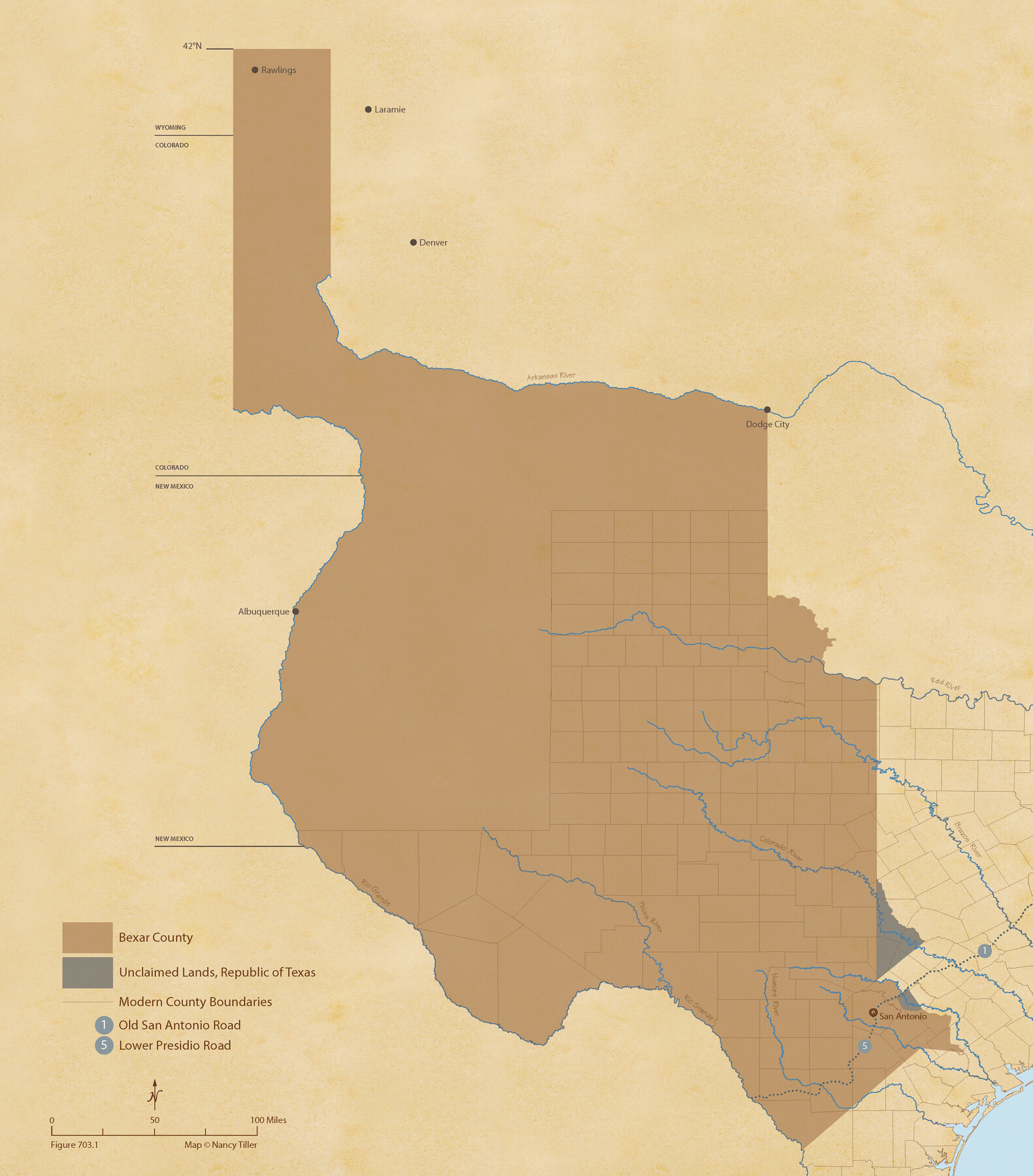
The Republic County of Bexar. Proposed, Late Fall 1837
Figure No. 703.1 from 'A Boundary Atlas of Texas, 1821-1845' by Jim Tiller
-
Map/Doc
96093
-
Collection
Nancy and Jim Tiller Digital Collection
-
Object Dates
2020/1/1 (Creation Date)
-
People and Organizations
Jim Tiller (Author)
Nancy Tiller (Cartographer)
Gang Gong (GIS Professional)
-
Counties
Bexar
-
Subjects
Atlas County Republic of Texas Texas Boundaries
-
Height x Width
24.6 x 21.6 inches
62.5 x 54.9 cm
-
Medium
digital image
-
Comments
To purchase a digital PDF copy of "A Boundary Atlas of Texas, 1821-1845" see 96437.
Part of: Nancy and Jim Tiller Digital Collection
The Chief Justice County of Jackson. April 24, 1837

Print $20.00
The Chief Justice County of Jackson. April 24, 1837
2020
Size 18.4 x 21.7 inches
Map/Doc 96051
The Mexican Municipality of Sabine. Created, December 15, 1835

Print $20.00
The Mexican Municipality of Sabine. Created, December 15, 1835
2020
Size 22.7 x 21.7 inches
Map/Doc 96031
A Boundary Atlas of Texas, 1821-1845

Digital $50.00
A Boundary Atlas of Texas, 1821-1845
2020
Map/Doc 96437
The Mexican Municipality of Gonzales. April 1834

Print $20.00
The Mexican Municipality of Gonzales. April 1834
2020
Size 20.4 x 21.7 inches
Map/Doc 96021
The Republic County of Nacogdoches. Proposed, Late Fall 1837

Print $20.00
The Republic County of Nacogdoches. Proposed, Late Fall 1837
2020
Size 17.5 x 21.7 inches
Map/Doc 96242
The Judicial District/County of Panola. Abolished, Spring 1842

Print $20.00
The Judicial District/County of Panola. Abolished, Spring 1842
2020
Size 19.3 x 21.7 inches
Map/Doc 96342
The Republic County of Harrison. Spring 1842

Print $20.00
The Republic County of Harrison. Spring 1842
2020
Size 18.6 x 21.7 inches
Map/Doc 96173
The Republic County of Montgomery. February 2, 1842

Print $20.00
The Republic County of Montgomery. February 2, 1842
2020
Size 19.9 x 21.7 inches
Map/Doc 96239
The Republic County of Washington. February 4, 1840

Print $20.00
The Republic County of Washington. February 4, 1840
2020
Size 20.3 x 21.7 inches
Map/Doc 96304
The Republic County of Bexar. December 2, 1841

Print $20.00
The Republic County of Bexar. December 2, 1841
2020
Size 14.8 x 21.7 inches
Map/Doc 96098
From Citizens of Red River County for the Creation of a New County to be Called Aurora, December 3, 1840

Print $20.00
From Citizens of Red River County for the Creation of a New County to be Called Aurora, December 3, 1840
2020
Size 19.8 x 21.7 inches
Map/Doc 96391
Republic Counties. January 1, 1840

Print $20.00
Republic Counties. January 1, 1840
2020
Size 24.5 x 21.7 inches
Map/Doc 96313
You may also like
Dickens County, Texas

Print $20.00
- Digital $50.00
Dickens County, Texas
1883
Size 22.4 x 18.6 inches
Map/Doc 722
Bandera County Working Sketch 10

Print $20.00
- Digital $50.00
Bandera County Working Sketch 10
1922
Size 17.9 x 19.4 inches
Map/Doc 67603
Trinity County Sketch File 14

Print $4.00
- Digital $50.00
Trinity County Sketch File 14
1862
Size 8.7 x 12.0 inches
Map/Doc 38540
Flight Mission No. CUG-3P, Frame 12, Kleberg County

Print $20.00
- Digital $50.00
Flight Mission No. CUG-3P, Frame 12, Kleberg County
1956
Size 18.5 x 22.3 inches
Map/Doc 86222
Right of Way and Track Map of The Missouri, Kansas & Texas Railway of Texas

Print $40.00
- Digital $50.00
Right of Way and Track Map of The Missouri, Kansas & Texas Railway of Texas
1918
Size 24.8 x 53.4 inches
Map/Doc 64534
Right of Way and Track Map of The Missouri, Kansas & Texas Railway of Texas

Print $40.00
- Digital $50.00
Right of Way and Track Map of The Missouri, Kansas & Texas Railway of Texas
1918
Size 25.6 x 52.6 inches
Map/Doc 64525
Texas-Indian Territory Gainesville Quadrangle

Print $20.00
- Digital $50.00
Texas-Indian Territory Gainesville Quadrangle
1902
Size 20.4 x 16.9 inches
Map/Doc 75102
Polk County Sketch File 27

Print $8.00
- Digital $50.00
Polk County Sketch File 27
1891
Size 14.1 x 8.7 inches
Map/Doc 34194
Red River County Working Sketch 35

Print $20.00
- Digital $50.00
Red River County Working Sketch 35
1964
Size 34.9 x 41.0 inches
Map/Doc 72018
Coleman County Sketch File 37

Print $4.00
- Digital $50.00
Coleman County Sketch File 37
1891
Size 11.1 x 8.4 inches
Map/Doc 18742
Liberty County Boundary File 2

Print $9.00
- Digital $50.00
Liberty County Boundary File 2
Size 17.0 x 11.0 inches
Map/Doc 56293
Flight Mission No. DQO-8K, Frame 112, Galveston County

Print $20.00
- Digital $50.00
Flight Mission No. DQO-8K, Frame 112, Galveston County
1952
Size 18.6 x 22.4 inches
Map/Doc 85194