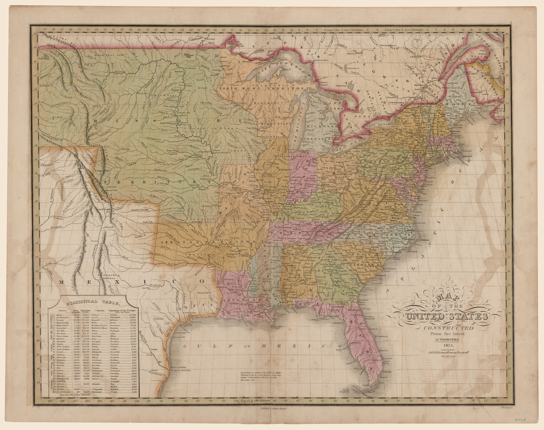
Map of the United States constructed from the latest authorities
-
Map/Doc
93924
-
Collection
General Map Collection
-
Object Dates
1825 (Creation Date)
2015/7/24 (File Date)
-
People and Organizations
A. Finley (Publisher)
-
Subjects
United States
-
Height x Width
19.4 x 24.5 inches
49.3 x 62.2 cm
-
Medium
paper, etching/engraving/lithograph
Part of: General Map Collection

Webb County Sketch File 15-1

Print $20.00
- Digital $50.00
Webb County Sketch File 15-1
1935
Size 35.0 x 25.2 inches
Map/Doc 12634
Flight Mission No. BRA-16M, Frame 115, Jefferson County

Print $20.00
- Digital $50.00
Flight Mission No. BRA-16M, Frame 115, Jefferson County
1953
Size 18.5 x 22.2 inches
Map/Doc 85725
Photostat of section of hydrographic surveys H-5399, H-4822, H-470

Print $2.00
- Digital $50.00
Photostat of section of hydrographic surveys H-5399, H-4822, H-470
1933
Size 10.8 x 8.1 inches
Map/Doc 61157
Brewster County Rolled Sketch 109

Print $20.00
- Digital $50.00
Brewster County Rolled Sketch 109
1961
Size 19.3 x 25.3 inches
Map/Doc 5261
Williamson County Sketch File 23

Print $4.00
- Digital $50.00
Williamson County Sketch File 23
1877
Size 12.8 x 8.1 inches
Map/Doc 40353
Outer Continental Shelf Leasing Maps (Texas Offshore Operations)

Print $20.00
- Digital $50.00
Outer Continental Shelf Leasing Maps (Texas Offshore Operations)
Size 17.2 x 13.7 inches
Map/Doc 75842
Bandera County Working Sketch 10

Print $20.00
- Digital $50.00
Bandera County Working Sketch 10
1922
Size 17.9 x 19.4 inches
Map/Doc 67603
Harrison County Working Sketch 12

Print $20.00
- Digital $50.00
Harrison County Working Sketch 12
1960
Size 26.6 x 31.4 inches
Map/Doc 66032
Montague County Sketch File 16

Print $20.00
- Digital $50.00
Montague County Sketch File 16
1853
Size 32.5 x 29.2 inches
Map/Doc 10546
McMullen County Sketch File 5

Print $4.00
- Digital $50.00
McMullen County Sketch File 5
1854
Size 8.7 x 8.3 inches
Map/Doc 31343
Atascosa County Working Sketch 31

Print $20.00
- Digital $50.00
Atascosa County Working Sketch 31
1981
Size 21.4 x 16.6 inches
Map/Doc 67227
You may also like
The Republic County of Brazoria. Proposed, Late Fall 1837-January 1, 1838

Print $20.00
The Republic County of Brazoria. Proposed, Late Fall 1837-January 1, 1838
2020
Size 13.0 x 21.7 inches
Map/Doc 96110
Irion County Rolled Sketch 18B

Print $152.00
- Digital $50.00
Irion County Rolled Sketch 18B
1978
Size 10.6 x 15.2 inches
Map/Doc 46087
Travis County Sketch File 11a

Print $4.00
- Digital $50.00
Travis County Sketch File 11a
1873
Size 10.0 x 8.0 inches
Map/Doc 38302
University Lands, Blocks 1-13 & Block 58, Crockett, Reagan & Upton Counties

Print $20.00
- Digital $50.00
University Lands, Blocks 1-13 & Block 58, Crockett, Reagan & Upton Counties
1936
Size 36.9 x 42.0 inches
Map/Doc 2409
Edwards County Sketch File 47

Print $24.00
- Digital $50.00
Edwards County Sketch File 47
1955
Size 11.4 x 8.9 inches
Map/Doc 21795
Kleberg County Rolled Sketch 10-39

Print $20.00
- Digital $50.00
Kleberg County Rolled Sketch 10-39
1952
Size 36.2 x 35.9 inches
Map/Doc 9363
Map of Texas to accompany Granger's Southern and Western Texas Guide

Print $20.00
- Digital $50.00
Map of Texas to accompany Granger's Southern and Western Texas Guide
1878
Size 26.7 x 20.8 inches
Map/Doc 96612
[Area between G. C. & S. F. RR. Co. Block 194 and Runnels County School Land Survey No. 3]
![91635, [Area between G. C. & S. F. RR. Co. Block 194 and Runnels County School Land Survey No. 3], Twichell Survey Records](https://historictexasmaps.com/wmedia_w700/maps/91635-1.tif.jpg)
Print $3.00
- Digital $50.00
[Area between G. C. & S. F. RR. Co. Block 194 and Runnels County School Land Survey No. 3]
1926
Size 16.6 x 11.9 inches
Map/Doc 91635
[Map showing T&P Lands in El Paso County]
![88931, [Map showing T&P Lands in El Paso County], Library of Congress](https://historictexasmaps.com/wmedia_w700/maps/88931.tif.jpg)
Print $20.00
[Map showing T&P Lands in El Paso County]
Size 22.4 x 17.3 inches
Map/Doc 88931
Fractional Township No. 8 South Range No. 1 East of the Indian Meridian, Indian Territory

Print $20.00
- Digital $50.00
Fractional Township No. 8 South Range No. 1 East of the Indian Meridian, Indian Territory
1898
Size 19.3 x 24.3 inches
Map/Doc 75200
Denton County Sketch File 22

Print $4.00
- Digital $50.00
Denton County Sketch File 22
1872
Size 8.5 x 16.0 inches
Map/Doc 20746
Sulphur River, Talco Sheet

Print $20.00
- Digital $50.00
Sulphur River, Talco Sheet
1917
Size 24.6 x 43.7 inches
Map/Doc 65160