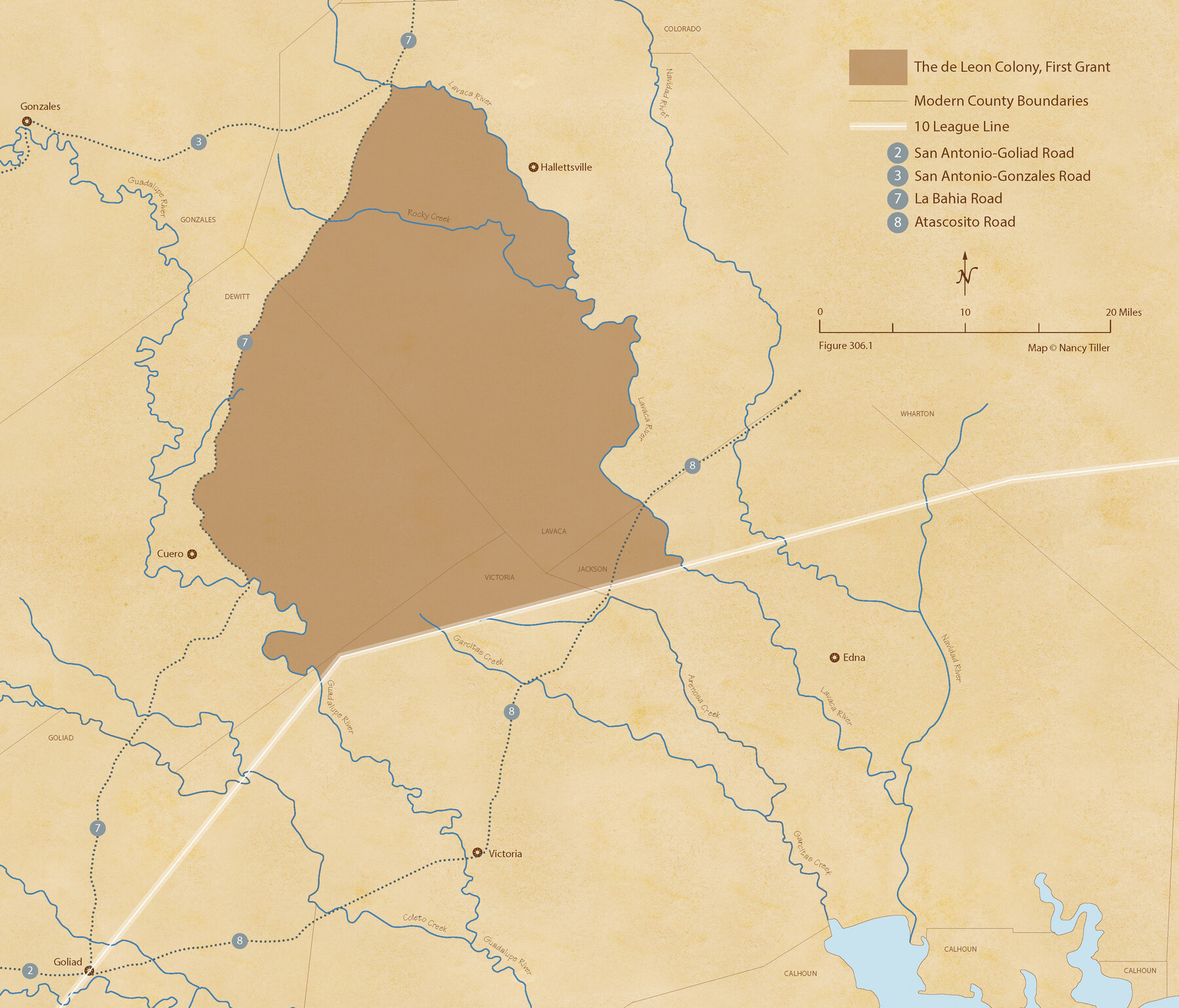
de Leon Empresario Colony. April 15, 1824
Figure No. 306.1 from 'A Boundary Atlas of Texas, 1821-1845' by Jim Tiller
-
Map/Doc
95988
-
Collection
Nancy and Jim Tiller Digital Collection
-
Object Dates
2020/1/1 (Creation Date)
-
People and Organizations
Jim Tiller (Author)
Nancy Tiller (Cartographer)
Gang Gong (GIS Professional)
-
Subjects
Atlas Colony Mexican Texas Texas Boundaries
-
Height x Width
18.5 x 21.7 inches
47.0 x 55.1 cm
-
Medium
digital image
-
Comments
To purchase a digital PDF copy of "A Boundary Atlas of Texas, 1821-1845" see 96437.
Part of: Nancy and Jim Tiller Digital Collection
Woodbury Empresario Colony. November 14, 1826

Print $20.00
Woodbury Empresario Colony. November 14, 1826
2020
Size 14.7 x 21.8 inches
Map/Doc 96011
The Chief Justice County of Nacogdoches. April 25, 1837

Print $20.00
The Chief Justice County of Nacogdoches. April 25, 1837
2020
Size 17.6 x 21.7 inches
Map/Doc 96063
The Chief Justice County of Matagorda. March 30, 1837

Print $20.00
The Chief Justice County of Matagorda. March 30, 1837
2020
Size 19.7 x 21.7 inches
Map/Doc 96057
The Republic County of Fannin. December 29, 1845

Print $20.00
The Republic County of Fannin. December 29, 1845
2020
Size 12.9 x 21.7 inches
Map/Doc 96130
The Chief Justice County of San Augustine. April 22, 1837

Print $20.00
The Chief Justice County of San Augustine. April 22, 1837
2020
Size 14.6 x 21.7 inches
Map/Doc 96070
The Judicial District/County of Hamilton. Created, February 2, 1842

Print $20.00
The Judicial District/County of Hamilton. Created, February 2, 1842
2020
Size 14.9 x 21.7 inches
Map/Doc 96329
The Republic County of Brazos. December 29, 1845

Print $20.00
The Republic County of Brazos. December 29, 1845
2020
Size 20.6 x 21.7 inches
Map/Doc 96117
The Republic County of Bastrop. December 29, 1845

Print $20.00
The Republic County of Bastrop. December 29, 1845
2020
Size 14.8 x 21.7 inches
Map/Doc 96092
Refinement of the Line by County Surveyors from Gonzales and Victoria Counties, April 14, 1838

Print $20.00
Refinement of the Line by County Surveyors from Gonzales and Victoria Counties, April 14, 1838
2020
Size 24.9 x 21.7 inches
Map/Doc 96379
Letter from Jesse Grimes Suggesting a Redefinition of the Boundary Between Harris and Montgomery Counties, April 30, 1838

Print $20.00
Letter from Jesse Grimes Suggesting a Redefinition of the Boundary Between Harris and Montgomery Counties, April 30, 1838
2020
Size 15.4 x 21.7 inches
Map/Doc 96381
The Chief Justice County of Liberty. Lands in Conflict with Harrisburg County

Print $20.00
The Chief Justice County of Liberty. Lands in Conflict with Harrisburg County
2020
Size 20.5 x 21.7 inches
Map/Doc 96056
DeWitt Empresario Colony. April 15, 1825

Print $20.00
DeWitt Empresario Colony. April 15, 1825
2020
Size 18.1 x 21.7 inches
Map/Doc 95991
You may also like
Roberts County Working Sketch 32

Print $20.00
- Digital $50.00
Roberts County Working Sketch 32
1978
Size 26.6 x 22.5 inches
Map/Doc 63558
Hutchinson County Rolled Sketch 44-2

Print $20.00
- Digital $50.00
Hutchinson County Rolled Sketch 44-2
2002
Size 24.0 x 36.0 inches
Map/Doc 77538
Falls County Sketch File 20

Print $12.00
- Digital $50.00
Falls County Sketch File 20
1869
Size 10.0 x 8.3 inches
Map/Doc 22388
Randall County Boundary File 2a

Print $14.00
- Digital $50.00
Randall County Boundary File 2a
Size 9.6 x 6.1 inches
Map/Doc 58118
Winkler County Working Sketch 10

Print $40.00
- Digital $50.00
Winkler County Working Sketch 10
1960
Size 30.3 x 61.0 inches
Map/Doc 72604
Brewster County Working Sketch 8

Print $20.00
- Digital $50.00
Brewster County Working Sketch 8
1910
Size 42.3 x 30.3 inches
Map/Doc 67541
Swisher County Rolled Sketch B

Print $20.00
- Digital $50.00
Swisher County Rolled Sketch B
Size 19.1 x 19.7 inches
Map/Doc 7908
Coast Chart No. 211 - Padre I. and Laguna Madre, Lat. 27° 12' to Lat. 26° 33', Texas

Print $20.00
- Digital $50.00
Coast Chart No. 211 - Padre I. and Laguna Madre, Lat. 27° 12' to Lat. 26° 33', Texas
1890
Size 40.1 x 33.7 inches
Map/Doc 73500
Texas Coordinate File 3

Print $40.00
- Digital $50.00
Texas Coordinate File 3
Size 36.1 x 49.1 inches
Map/Doc 75306
Flight Mission No. DQN-1K, Frame 131, Calhoun County

Print $20.00
- Digital $50.00
Flight Mission No. DQN-1K, Frame 131, Calhoun County
1953
Size 18.6 x 22.4 inches
Map/Doc 84194
Terrell County Boundary File 1

Print $12.00
- Digital $50.00
Terrell County Boundary File 1
Size 8.9 x 6.2 inches
Map/Doc 59196
Wise County Sketch File 23

Print $4.00
- Digital $50.00
Wise County Sketch File 23
1859
Size 7.9 x 12.9 inches
Map/Doc 40568