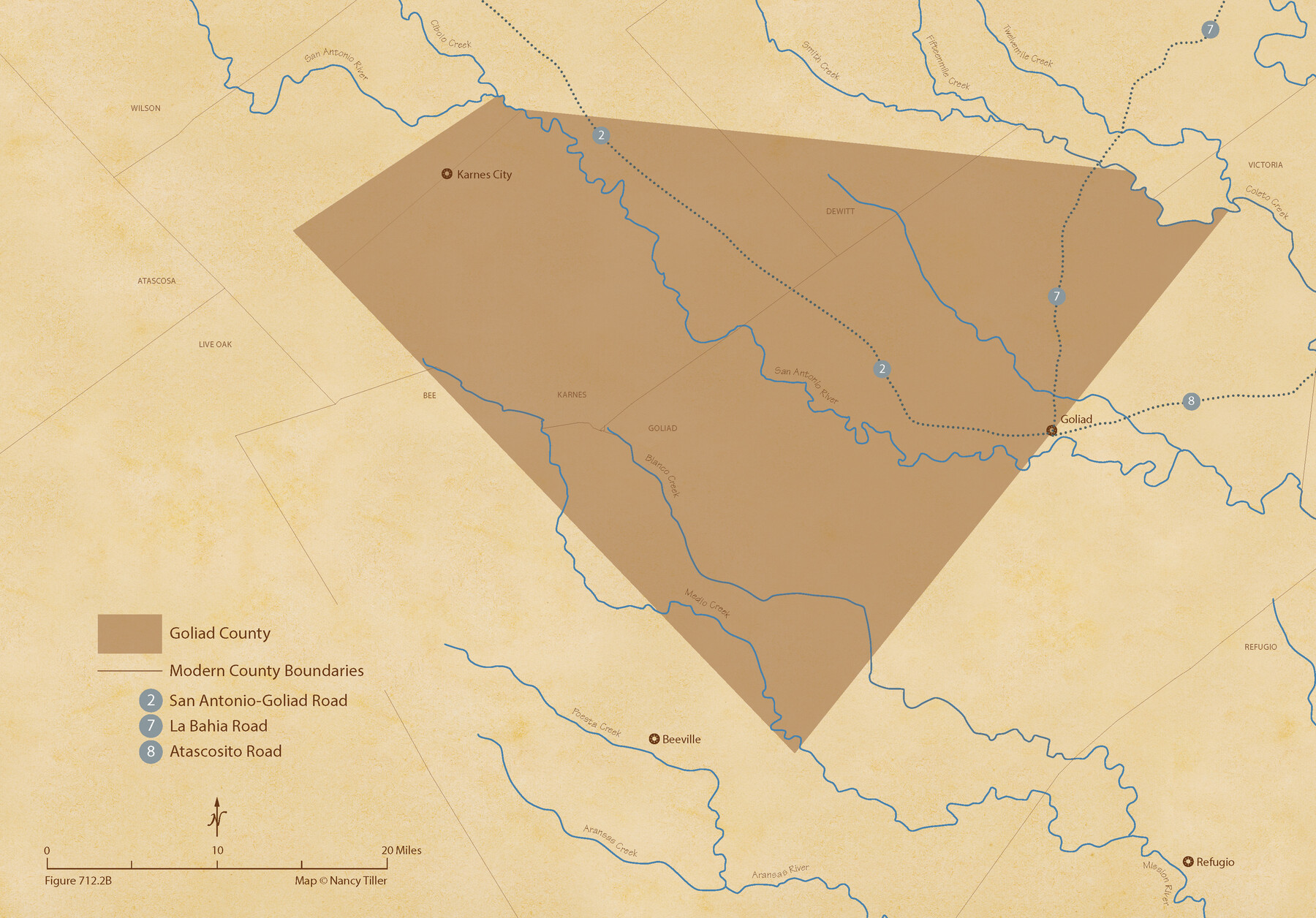
The Republic County of Goliad. Proposed, Late Fall 1837-December 31, 1838
Figure No. 712.2 from 'A Boundary Atlas of Texas, 1821-1845' by Jim Tiller
-
Map/Doc
96148
-
Collection
Nancy and Jim Tiller Digital Collection
-
Object Dates
2020/1/1 (Creation Date)
-
People and Organizations
Jim Tiller (Author)
Nancy Tiller (Cartographer)
Gang Gong (GIS Professional)
-
Counties
Goliad
-
Subjects
Atlas County Republic of Texas Texas Boundaries
-
Height x Width
15.1 x 21.7 inches
38.4 x 55.1 cm
-
Medium
digital image
-
Comments
To purchase a digital PDF copy of "A Boundary Atlas of Texas, 1821-1845" see 96437.
Part of: Nancy and Jim Tiller Digital Collection
The Judicial District/County of Lavaca. Abolished, Spring 1842

Print $20.00
The Judicial District/County of Lavaca. Abolished, Spring 1842
2020
Size 14.6 x 21.7 inches
Map/Doc 96332
The Mexican Department of Bexar. March 18, 1834

Print $20.00
The Mexican Department of Bexar. March 18, 1834
2020
Size 16.0 x 21.7 inches
Map/Doc 95970
The Judicial District/County of Madison. Abolished, Spring 1842

Print $20.00
The Judicial District/County of Madison. Abolished, Spring 1842
2020
Size 18.2 x 21.7 inches
Map/Doc 96334
The Land Offices. No. 6, Washington, December 22, 1836

Print $20.00
The Land Offices. No. 6, Washington, December 22, 1836
2020
Size 16.5 x 21.7 inches
Map/Doc 96419
The Mexican Department of Nacogdoches. On the Eve of Texas Independence, 1836

Print $20.00
The Mexican Department of Nacogdoches. On the Eve of Texas Independence, 1836
2020
Size 18.4 x 21.7 inches
Map/Doc 95974
The Republic County of Gonzales. Boundaries Defined, December 14, 1837

Print $20.00
The Republic County of Gonzales. Boundaries Defined, December 14, 1837
2020
Size 14.7 x 21.7 inches
Map/Doc 96153
The Judicial District/County of Trinity. Created, December 7, 1841

Print $20.00
The Judicial District/County of Trinity. Created, December 7, 1841
2020
Size 14.7 x 21.7 inches
Map/Doc 96350
The Republic County of Red River. Spring 1842

Print $20.00
The Republic County of Red River. Spring 1842
2020
Size 21.0 x 21.7 inches
Map/Doc 96254
The Republic County of Washington. Spring 1842

Print $20.00
The Republic County of Washington. Spring 1842
2020
Size 11.8 x 21.7 inches
Map/Doc 96308
Austin Empresario Colony. November 20, 1827

Print $20.00
Austin Empresario Colony. November 20, 1827
2020
Size 14.7 x 21.7 inches
Map/Doc 95981
From Citizens of Washington County Living East of the Brazos River and West of the Navasota River for the Creation of a New County (Unnamed), Undated

Print $20.00
From Citizens of Washington County Living East of the Brazos River and West of the Navasota River for the Creation of a New County (Unnamed), Undated
2020
Size 20.4 x 21.7 inches
Map/Doc 96408
The Republic County of Harrison. December 31, 1844

Print $20.00
The Republic County of Harrison. December 31, 1844
2020
Size 18.6 x 21.7 inches
Map/Doc 96176
You may also like
Map of Cherokee County

Print $40.00
- Digital $50.00
Map of Cherokee County
1933
Size 59.9 x 41.5 inches
Map/Doc 1799
Hood County Sketch File 25

Print $12.00
- Digital $50.00
Hood County Sketch File 25
1958
Size 11.3 x 8.9 inches
Map/Doc 26623
Liberty County Working Sketch 9

Print $20.00
- Digital $50.00
Liberty County Working Sketch 9
Size 34.6 x 27.3 inches
Map/Doc 70468
Menard County Working Sketch 10

Print $20.00
- Digital $50.00
Menard County Working Sketch 10
1938
Size 21.8 x 18.5 inches
Map/Doc 70957
Abandoned and Canceled Surveys - Volume 3 of 3, Counties L-Z

Abandoned and Canceled Surveys - Volume 3 of 3, Counties L-Z
Map/Doc 83250
Runnels County Working Sketch 15

Print $20.00
- Digital $50.00
Runnels County Working Sketch 15
1950
Size 22.8 x 18.5 inches
Map/Doc 63611
County Map of the Pan-Handle of Texas and the line of the Texas Pan-Handle Route

Print $20.00
- Digital $50.00
County Map of the Pan-Handle of Texas and the line of the Texas Pan-Handle Route
1900
Size 7.2 x 10.3 inches
Map/Doc 95888
Kinney County Sketch File 15

Print $20.00
- Digital $50.00
Kinney County Sketch File 15
1887
Size 13.0 x 19.0 inches
Map/Doc 11940
[Subdivision Plat of 80 acres]
![93075, [Subdivision Plat of 80 acres], Twichell Survey Records](https://historictexasmaps.com/wmedia_w700/maps/93075-1.tif.jpg)
Print $2.00
- Digital $50.00
[Subdivision Plat of 80 acres]
Size 11.7 x 6.2 inches
Map/Doc 93075
Flight Mission No. DQO-2K, Frame 163, Galveston County

Print $20.00
- Digital $50.00
Flight Mission No. DQO-2K, Frame 163, Galveston County
1952
Size 18.8 x 22.5 inches
Map/Doc 85052
The Chief Justice County of Bexar. Lands in Conflict with San Patricio County

Print $20.00
The Chief Justice County of Bexar. Lands in Conflict with San Patricio County
2020
Size 14.7 x 21.6 inches
Map/Doc 96040
The Republic County of Milam. January 15, 1842

Print $20.00
The Republic County of Milam. January 15, 1842
2020
Size 17.4 x 21.6 inches
Map/Doc 96230