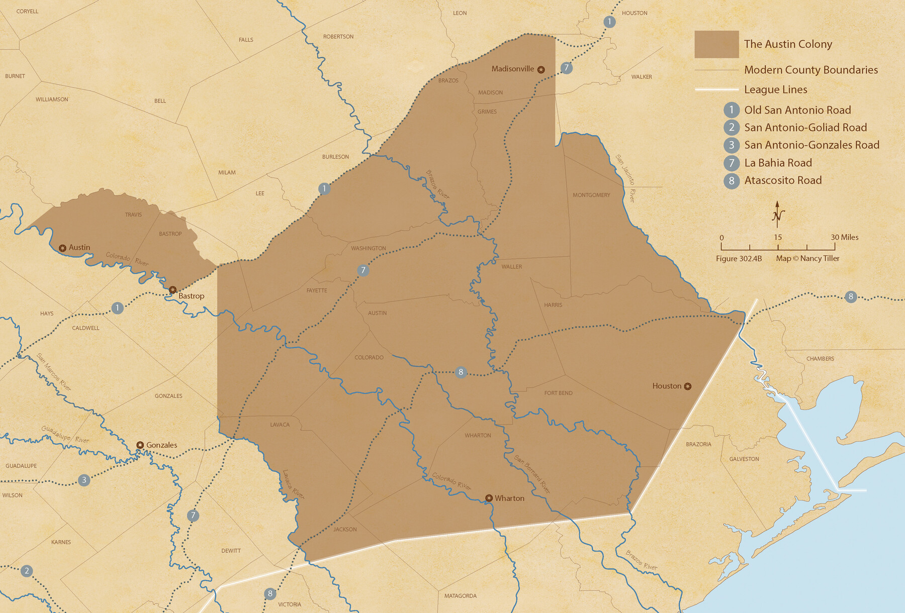
Austin Empresario Colony. November 20, 1827
Figure No. 302.4 from 'A Boundary Atlas of Texas, 1821-1845' by Jim Tiller
-
Map/Doc
95981
-
Collection
Nancy and Jim Tiller Digital Collection
-
Object Dates
2020/1/1 (Creation Date)
-
People and Organizations
Jim Tiller (Author)
Nancy Tiller (Cartographer)
Gang Gong (GIS Professional)
-
Subjects
Atlas Colony Mexican Texas Texas Boundaries
-
Height x Width
14.7 x 21.7 inches
37.3 x 55.1 cm
-
Medium
digital image
-
Comments
To purchase a digital PDF copy of "A Boundary Atlas of Texas, 1821-1845" see 96437.
Part of: Nancy and Jim Tiller Digital Collection
The Republic County of Bastrop. December 29, 1845

Print $20.00
The Republic County of Bastrop. December 29, 1845
2020
Size 14.8 x 21.7 inches
Map/Doc 96092
From Citizens of Nacogdoches County Living Near the Sabine River for the Creation of a New Judicial County (Unnamed), Undated

Print $20.00
From Citizens of Nacogdoches County Living Near the Sabine River for the Creation of a New Judicial County (Unnamed), Undated
2020
Size 19.9 x 21.7 inches
Map/Doc 96411
The Republic County of Austin. January 29, 1842

Print $20.00
The Republic County of Austin. January 29, 1842
2020
Size 14.7 x 21.7 inches
Map/Doc 96086
From Citizens of Austin County Requesting to be Attached to Washington County, Undated

Print $20.00
From Citizens of Austin County Requesting to be Attached to Washington County, Undated
2020
Size 18.8 x 21.7 inches
Map/Doc 96398
The Republic County of Refugio. December 2, 1841

Print $20.00
The Republic County of Refugio. December 2, 1841
2020
Size 22.3 x 21.6 inches
Map/Doc 96257
The Republic County of Harrison. February 1, 1842

Print $20.00
The Republic County of Harrison. February 1, 1842
2020
Size 18.6 x 21.7 inches
Map/Doc 96172
From Citizens of Gonzales County for the Creation of a New Judicial County (Unnamed), December 14, 1841

Print $20.00
From Citizens of Gonzales County for the Creation of a New Judicial County (Unnamed), December 14, 1841
2020
Size 24.1 x 21.7 inches
Map/Doc 96410
The Mexican Municipality of Matagorda. December 28, 1834

Print $20.00
The Mexican Municipality of Matagorda. December 28, 1834
2020
Size 15.9 x 21.7 inches
Map/Doc 96026
The Republic County of Shelby. December 29, 1845

Print $20.00
The Republic County of Shelby. December 29, 1845
2020
Size 20.0 x 21.7 inches
Map/Doc 96288
The Judicial District/County of Burleson. Created, January 15, 1842

Print $20.00
The Judicial District/County of Burleson. Created, January 15, 1842
2020
Size 14.1 x 21.7 inches
Map/Doc 96320
From Citizens of Brazoria County to Annex the Island of San Luis, December 12, 1839

Print $20.00
From Citizens of Brazoria County to Annex the Island of San Luis, December 12, 1839
2020
Size 13.8 x 21.7 inches
Map/Doc 96387
The Republic County of Lamar. January 28, 1841

Print $20.00
The Republic County of Lamar. January 28, 1841
2020
Size 16.4 x 21.7 inches
Map/Doc 96203
You may also like
Panola County Sketch File 20

Print $22.00
- Digital $50.00
Panola County Sketch File 20
Size 8.3 x 14.6 inches
Map/Doc 33485
Flight Mission No. CUG-3P, Frame 81, Kleberg County

Print $20.00
- Digital $50.00
Flight Mission No. CUG-3P, Frame 81, Kleberg County
1956
Size 18.3 x 22.1 inches
Map/Doc 86256
Parker County Sketch File 15

Print $4.00
- Digital $50.00
Parker County Sketch File 15
1861
Size 8.3 x 8.0 inches
Map/Doc 33548
Montgomery County Rolled Sketch 43

Print $20.00
- Digital $50.00
Montgomery County Rolled Sketch 43
1971
Size 32.1 x 34.3 inches
Map/Doc 6822
Trinity River, Big Creek Sheet

Print $40.00
- Digital $50.00
Trinity River, Big Creek Sheet
1924
Size 48.0 x 36.4 inches
Map/Doc 65179
Palo Pinto County Sketch File 3

Print $20.00
- Digital $50.00
Palo Pinto County Sketch File 3
1850
Size 24.6 x 19.3 inches
Map/Doc 12132
General Highway Map, Navarro County, Texas

Print $20.00
General Highway Map, Navarro County, Texas
1939
Size 24.7 x 18.4 inches
Map/Doc 79206
Map of Trinity Co.

Print $20.00
- Digital $50.00
Map of Trinity Co.
1896
Size 40.7 x 39.1 inches
Map/Doc 63079
Coryell County Working Sketch 25

Print $20.00
- Digital $50.00
Coryell County Working Sketch 25
1986
Size 22.2 x 29.4 inches
Map/Doc 68232
Flight Mission No. BRA-6M, Frame 84, Jefferson County

Print $20.00
- Digital $50.00
Flight Mission No. BRA-6M, Frame 84, Jefferson County
1953
Size 18.6 x 22.4 inches
Map/Doc 85428
Parmer County Working Sketch 2

Print $20.00
- Digital $50.00
Parmer County Working Sketch 2
1914
Map/Doc 71470
Cherokee County Rolled Sketch 2

Print $20.00
- Digital $50.00
Cherokee County Rolled Sketch 2
1954
Size 44.6 x 36.0 inches
Map/Doc 8596