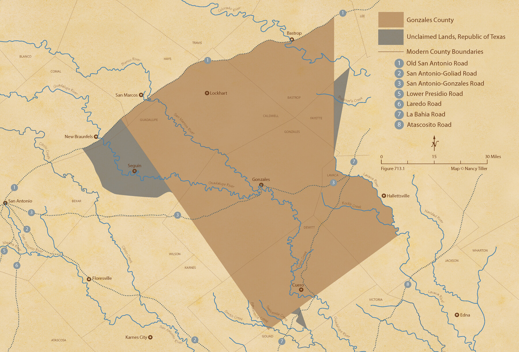
The Republic County of Gonzales. Boundaries Defined, December 14, 1837
Figure No. 713.1 from 'A Boundary Atlas of Texas, 1821-1845' by Jim Tiller
-
Map/Doc
96153
-
Collection
Nancy and Jim Tiller Digital Collection
-
Object Dates
2020/1/1 (Creation Date)
-
People and Organizations
Jim Tiller (Author)
Nancy Tiller (Cartographer)
Gang Gong (GIS Professional)
-
Counties
Gonzales
-
Subjects
Atlas County Republic of Texas Texas Boundaries
-
Height x Width
14.7 x 21.7 inches
37.3 x 55.1 cm
-
Medium
digital image
-
Comments
To purchase a digital PDF copy of "A Boundary Atlas of Texas, 1821-1845" see 96437.
Part of: Nancy and Jim Tiller Digital Collection
The Republic County of Nacogdoches. December 6, 1841

Print $20.00
The Republic County of Nacogdoches. December 6, 1841
2020
Size 15.9 x 21.8 inches
Map/Doc 96246
The Republic County of Matagorda. 1840

Print $20.00
The Republic County of Matagorda. 1840
2020
Size 21.0 x 21.7 inches
Map/Doc 96218
Letter from Jesse Grimes Suggesting a Redefinition of the Boundary Between Harris and Montgomery Counties, April 30, 1838

Print $20.00
Letter from Jesse Grimes Suggesting a Redefinition of the Boundary Between Harris and Montgomery Counties, April 30, 1838
2020
Size 15.4 x 21.7 inches
Map/Doc 96381
The Republic County of Galveston. December 16, 1839

Print $20.00
The Republic County of Galveston. December 16, 1839
2020
Size 14.7 x 21.9 inches
Map/Doc 96144
The Republic County of Gonzales. May 3, 1838

Print $20.00
The Republic County of Gonzales. May 3, 1838
2020
Size 14.7 x 21.7 inches
Map/Doc 96155
The Republic County of Harrison. Spring 1842

Print $20.00
The Republic County of Harrison. Spring 1842
2020
Size 18.6 x 21.7 inches
Map/Doc 96173
A Boundary Atlas of Texas, 1821-1845

Digital $50.00
A Boundary Atlas of Texas, 1821-1845
2020
Map/Doc 96437
The Republic County of Shelby. January 28, 1839

Print $20.00
The Republic County of Shelby. January 28, 1839
2020
Size 21.1 x 21.7 inches
Map/Doc 96281
The Republic County of Matagorda. January 1, 1838

Print $20.00
The Republic County of Matagorda. January 1, 1838
2020
Size 21.0 x 21.7 inches
Map/Doc 96216
The Judicial District/County of Lavaca. Created, January 29, 1842

Print $20.00
The Judicial District/County of Lavaca. Created, January 29, 1842
2020
Size 14.6 x 21.7 inches
Map/Doc 96331
The Chief Justice County of Bexar. Lands in Conflict with Victoria County

Print $20.00
The Chief Justice County of Bexar. Lands in Conflict with Victoria County
2020
Size 16.1 x 21.6 inches
Map/Doc 96041
The Judicial District/County of Guadalupe. Created, January 29, 1842

Print $20.00
The Judicial District/County of Guadalupe. Created, January 29, 1842
2020
Size 16.7 x 21.7 inches
Map/Doc 96327
You may also like
Moore County Working Sketch 14

Print $20.00
- Digital $50.00
Moore County Working Sketch 14
1972
Size 32.7 x 19.8 inches
Map/Doc 71196
Travis County Sketch File 2

Print $4.00
- Digital $50.00
Travis County Sketch File 2
1851
Size 8.2 x 9.9 inches
Map/Doc 38271
Uvalde County Working Sketch 18

Print $20.00
- Digital $50.00
Uvalde County Working Sketch 18
1948
Size 33.0 x 26.5 inches
Map/Doc 72088
Fannin County Boundary File 4

Print $10.00
- Digital $50.00
Fannin County Boundary File 4
Size 8.5 x 8.6 inches
Map/Doc 53304
The Judicial District/County of Pashcal. Created, January 28, 1841

Print $20.00
The Judicial District/County of Pashcal. Created, January 28, 1841
2020
Size 15.0 x 21.7 inches
Map/Doc 96343

Map of Castro's Colony - Bexar District

Print $20.00
- Digital $50.00
Map of Castro's Colony - Bexar District
1851
Size 36.4 x 33.1 inches
Map/Doc 1962
Duval County Sketch File 4b

Print $4.00
- Digital $50.00
Duval County Sketch File 4b
1874
Size 10.4 x 7.8 inches
Map/Doc 21282
Right of Way and Track Map of The Missouri, Kansas & Texas Railway of Texas

Print $40.00
- Digital $50.00
Right of Way and Track Map of The Missouri, Kansas & Texas Railway of Texas
1918
Size 25.4 x 75.5 inches
Map/Doc 64533
Kenedy County Rolled Sketch 6

Print $20.00
- Digital $50.00
Kenedy County Rolled Sketch 6
1911
Size 28.5 x 25.4 inches
Map/Doc 6463
Fractional Township No. 10 South Range No. 25 East of the Indian Meridian, Indian Territory

Print $20.00
- Digital $50.00
Fractional Township No. 10 South Range No. 25 East of the Indian Meridian, Indian Territory
1898
Size 19.2 x 24.3 inches
Map/Doc 75244
Dimmit County Sketch File 47

Print $24.00
- Digital $50.00
Dimmit County Sketch File 47
1908
Size 11.2 x 9.0 inches
Map/Doc 21178