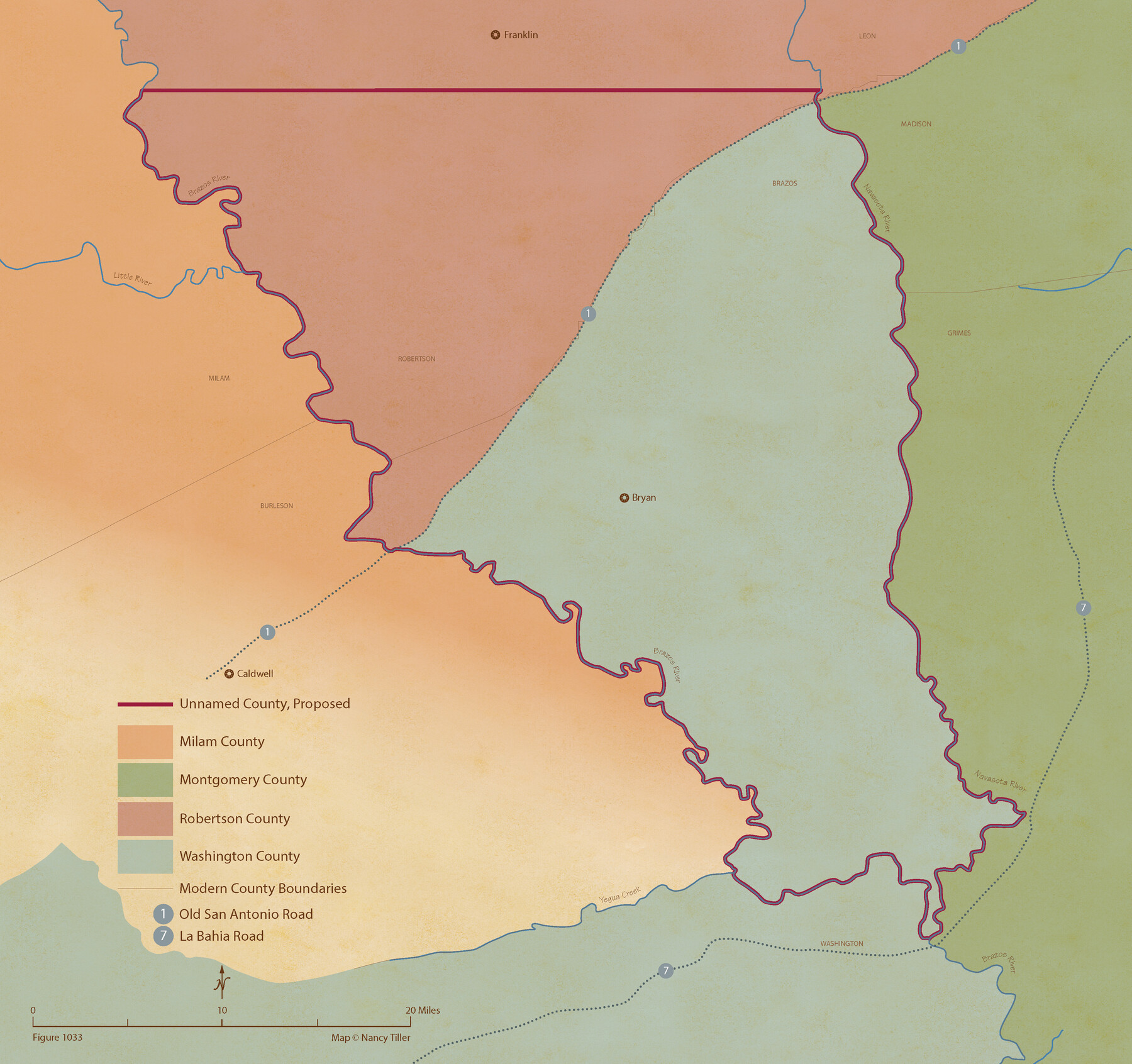
From Citizens of Washington County Living East of the Brazos River and West of the Navasota River for the Creation of a New County (Unnamed), Undated
Figure No. 1033 from 'A Boundary Atlas of Texas, 1821-1845' by Jim Tiller
-
Map/Doc
96408
-
Collection
Nancy and Jim Tiller Digital Collection
-
Object Dates
2020/1/1 (Creation Date)
-
People and Organizations
Jim Tiller (Author)
Nancy Tiller (Cartographer)
Gang Gong (GIS Professional)
-
Subjects
Atlas Republic of Texas Texas Boundaries
-
Height x Width
20.4 x 21.7 inches
51.8 x 55.1 cm
-
Medium
digital image
-
Comments
To purchase a digital PDF copy of "A Boundary Atlas of Texas, 1821-1845" see 96437.
Part of: Nancy and Jim Tiller Digital Collection
The Republic County of Shelby. January 30, 1841

Print $20.00
The Republic County of Shelby. January 30, 1841
2020
Size 20.0 x 21.7 inches
Map/Doc 96282
de Leon Empresario Colony. April 15, 1824

Print $20.00
de Leon Empresario Colony. April 15, 1824
2020
Size 18.5 x 21.7 inches
Map/Doc 95988
The Republic County of Montgomery. February 2, 1842

Print $20.00
The Republic County of Montgomery. February 2, 1842
2020
Size 19.9 x 21.7 inches
Map/Doc 96239
The Chief Justice County of Shelby. Undated

Print $20.00
The Chief Justice County of Shelby. Undated
2020
Size 23.5 x 21.7 inches
Map/Doc 96074
The Chief Justice County of Nacogdoches. Lands in Conflict with Red River and Washington Counties

Print $20.00
The Chief Justice County of Nacogdoches. Lands in Conflict with Red River and Washington Counties
2020
Size 17.6 x 21.7 inches
Map/Doc 96064
The Republic County of Harris. Proposed, Late Fall 1837

Print $20.00
The Republic County of Harris. Proposed, Late Fall 1837
2020
Size 17.7 x 21.7 inches
Map/Doc 96161
The Chief Justice County of Red River. Lands in Conflict with Nacogdoches County

Print $20.00
The Chief Justice County of Red River. Lands in Conflict with Nacogdoches County
2020
Size 17.4 x 21.8 inches
Map/Doc 96066
The Republic County of San Patricio. 1840

Print $20.00
The Republic County of San Patricio. 1840
2020
Size 22.2 x 21.7 inches
Map/Doc 96276
The Republic County of Goliad. Proposed, Late Fall 1837-December 31, 1838

Print $20.00
The Republic County of Goliad. Proposed, Late Fall 1837-December 31, 1838
2020
Size 15.1 x 21.7 inches
Map/Doc 96148

The Republic County of San Augustine. December 29, 1845

Print $20.00
The Republic County of San Augustine. December 29, 1845
2020
Size 18.8 x 21.7 inches
Map/Doc 96272
The Mexican Department of Bexar. May 6, 1833

Print $20.00
The Mexican Department of Bexar. May 6, 1833
2020
Size 16.0 x 21.6 inches
Map/Doc 95969
You may also like
Medina County Working Sketch 4

Print $40.00
- Digital $50.00
Medina County Working Sketch 4
1945
Size 52.6 x 35.5 inches
Map/Doc 70919
Flight Mission No. DCL-4C, Frame 122, Kenedy County

Print $20.00
- Digital $50.00
Flight Mission No. DCL-4C, Frame 122, Kenedy County
1943
Size 18.6 x 22.3 inches
Map/Doc 85821
Kimble County Sketch File 9

Print $22.00
- Digital $50.00
Kimble County Sketch File 9
1871
Size 8.2 x 14.1 inches
Map/Doc 28927
Crockett County Rolled Sketch 88C

Print $20.00
- Digital $50.00
Crockett County Rolled Sketch 88C
1973
Size 36.3 x 38.1 inches
Map/Doc 8728
Jasper County Working Sketch 18

Print $20.00
- Digital $50.00
Jasper County Working Sketch 18
1934
Size 22.4 x 30.5 inches
Map/Doc 66480
Brooks County Boundary File 2

Print $8.00
- Digital $50.00
Brooks County Boundary File 2
Size 8.6 x 11.3 inches
Map/Doc 50839
Edwards County Working Sketch 41

Print $20.00
- Digital $50.00
Edwards County Working Sketch 41
1949
Size 29.5 x 30.7 inches
Map/Doc 68917
Main Line Routes of the Santa Fe Lines

Main Line Routes of the Santa Fe Lines
Size 12.1 x 18.1 inches
Map/Doc 94157
[Blocks 33-35, Township 5N]
![92029, [Blocks 33-35, Township 5N], Twichell Survey Records](https://historictexasmaps.com/wmedia_w700/maps/92029-1.tif.jpg)
Print $20.00
- Digital $50.00
[Blocks 33-35, Township 5N]
Size 37.4 x 23.8 inches
Map/Doc 92029
Gonzales County Working Sketch 14

Print $20.00
- Digital $50.00
Gonzales County Working Sketch 14
1981
Size 18.3 x 20.9 inches
Map/Doc 63230
Galveston Harbor, Texas

Print $20.00
- Digital $50.00
Galveston Harbor, Texas
1882
Size 15.0 x 19.5 inches
Map/Doc 97281
San Jacinto County

Print $20.00
- Digital $50.00
San Jacinto County
1942
Size 47.1 x 42.8 inches
Map/Doc 63017