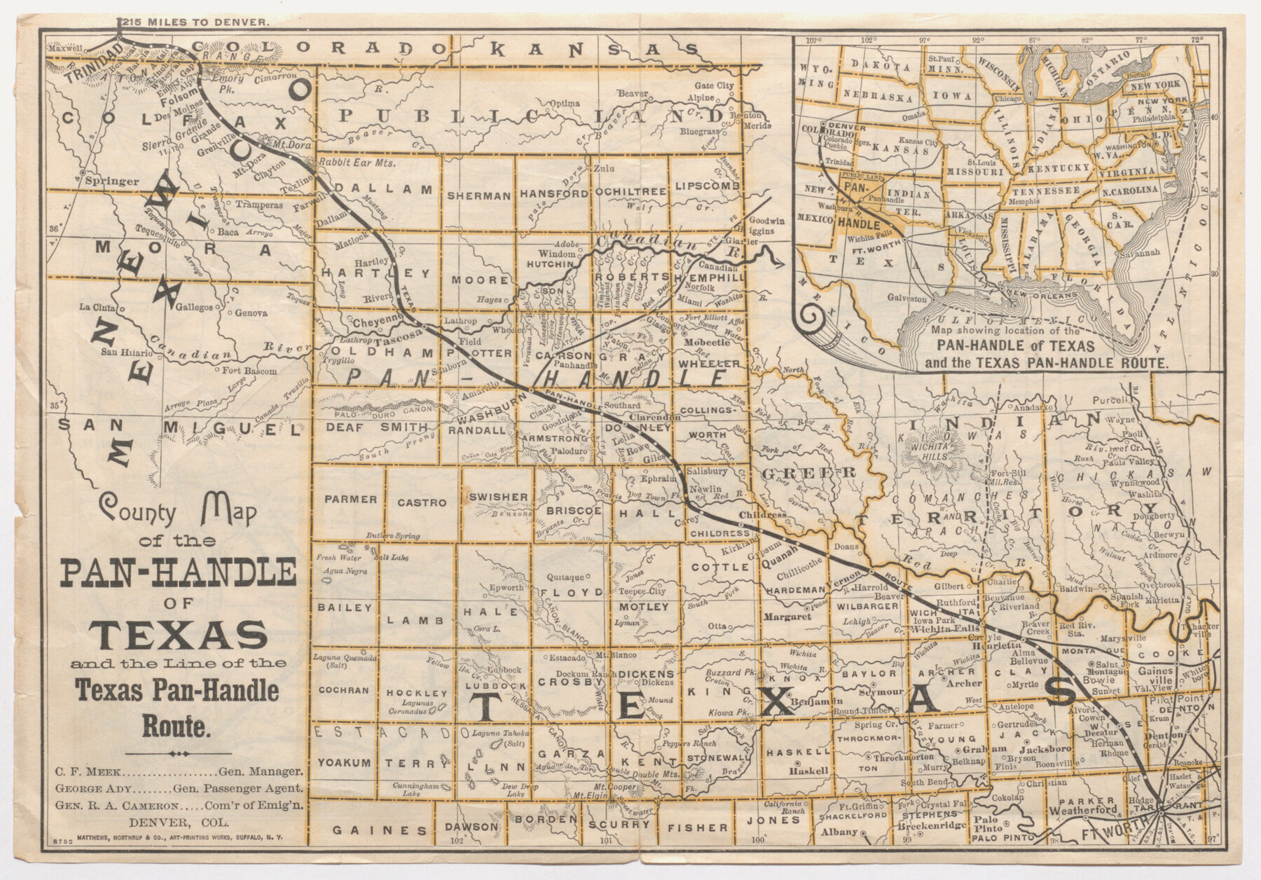
County Map of the Pan-Handle of Texas and the line of the Texas Pan-Handle Route
[Inset:] Map showing location of the Pan-Handle of Texas and the Texas Pan-Handle Route
-
Map/Doc
95888
-
Collection
Cobb Digital Map Collection
-
Object Dates
[1900 ca.] (Creation Date)
-
People and Organizations
Matthews, Northrup & Co. (Printer)
-
Subjects
Railroads State of Texas
-
Height x Width
7.2 x 10.3 inches
18.3 x 26.2 cm
-
Medium
digital image
-
Comments
Courtesy of John & Diana Cobb.
To view map on verso, click "Download PDF" link above.
Related maps
County Map of the Pan-Handle of Texas, and the line of the Denver, Texas and Ft. Worth R'y

Print $20.00
County Map of the Pan-Handle of Texas, and the line of the Denver, Texas and Ft. Worth R'y
1888
Size 7.5 x 10.9 inches
Map/Doc 76296
Part of: Cobb Digital Map Collection
What to See - Where to Go in El Paso, Texas

What to See - Where to Go in El Paso, Texas
1929
Size 9.4 x 8.4 inches
Map/Doc 97048
The Rand McNally New Commercial Atlas Map of Texas

Print $20.00
- Digital $50.00
The Rand McNally New Commercial Atlas Map of Texas
1920
Size 29.0 x 40.1 inches
Map/Doc 95863
Map of Texas with population and location of principal towns and cities according to latest reliable statistics

Print $20.00
- Digital $50.00
Map of Texas with population and location of principal towns and cities according to latest reliable statistics
1909
Size 18.3 x 20.2 inches
Map/Doc 95874
Map of the State of Texas

Print $20.00
- Digital $50.00
Map of the State of Texas
1881
Size 15.7 x 21.7 inches
Map/Doc 96614
Sectional map of Texas traversed by the Missouri, Kansas & Texas Railway, showing the crops adapted to each section, with the elevation and annual rainfall

Print $20.00
- Digital $50.00
Sectional map of Texas traversed by the Missouri, Kansas & Texas Railway, showing the crops adapted to each section, with the elevation and annual rainfall
1904
Size 21.9 x 23.0 inches
Map/Doc 95815
Map of Texas with population and location of principal towns and cities according to latest reliable statistics

Print $20.00
- Digital $50.00
Map of Texas with population and location of principal towns and cities according to latest reliable statistics
1910
Size 19.1 x 20.6 inches
Map/Doc 95878
Santa Rosa, the Saint of Roses - Lower Rio Grande Valley

Santa Rosa, the Saint of Roses - Lower Rio Grande Valley
1920
Map/Doc 96734
Arlancy the Land of Plenty Farms

Print $20.00
- Digital $50.00
Arlancy the Land of Plenty Farms
1925
Size 10.9 x 16.6 inches
Map/Doc 96737
A Geographically Correct Map of the State of Texas

Print $20.00
- Digital $50.00
A Geographically Correct Map of the State of Texas
1878
Size 19.5 x 21.0 inches
Map/Doc 95757

A Geographically Correct County Map of States Traversed by the St. Louis, Iron Mountain and Southern Railway and its connections

Print $20.00
- Digital $50.00
A Geographically Correct County Map of States Traversed by the St. Louis, Iron Mountain and Southern Railway and its connections
1878
Size 16.9 x 27.0 inches
Map/Doc 95785
The Newest Land Of Promise - The Pecos Valley in Texas

Print $20.00
- Digital $50.00
The Newest Land Of Promise - The Pecos Valley in Texas
1900
Size 17.8 x 22.9 inches
Map/Doc 97038
You may also like
Briscoe County Sketch File A-1

Print $16.00
- Digital $50.00
Briscoe County Sketch File A-1
1894
Size 10.7 x 8.4 inches
Map/Doc 16399

Goliad County Sketch File 14

Print $4.00
- Digital $50.00
Goliad County Sketch File 14
1878
Size 8.6 x 11.4 inches
Map/Doc 24243
King County Rolled Sketch 13

Print $40.00
- Digital $50.00
King County Rolled Sketch 13
Size 50.5 x 29.3 inches
Map/Doc 9353
Brewster County Sketch File 18

Print $8.00
- Digital $50.00
Brewster County Sketch File 18
1942
Size 13.8 x 7.6 inches
Map/Doc 15813
Upshur County Rolled Sketch 5

Print $20.00
- Digital $50.00
Upshur County Rolled Sketch 5
2000
Size 35.2 x 24.4 inches
Map/Doc 8064
Hemphill County Working Sketch 33

Print $20.00
- Digital $50.00
Hemphill County Working Sketch 33
1976
Size 39.6 x 32.3 inches
Map/Doc 66128
Van Zandt County Sketch File 26

Print $4.00
- Digital $50.00
Van Zandt County Sketch File 26
1858
Size 6.7 x 7.9 inches
Map/Doc 39445
Throckmorton County Working Sketch 7

Print $20.00
- Digital $50.00
Throckmorton County Working Sketch 7
1956
Size 25.8 x 32.0 inches
Map/Doc 62116
Index for Texas Railroad ROW & track maps available on microfilm at THD & Archives and Records

Print $2.00
- Digital $50.00
Index for Texas Railroad ROW & track maps available on microfilm at THD & Archives and Records
1977
Size 11.3 x 8.8 inches
Map/Doc 60760
Donley County Working Sketch 3

Print $40.00
- Digital $50.00
Donley County Working Sketch 3
Size 58.7 x 44.8 inches
Map/Doc 68736
General Land Office and State Reclamation Department - An Index Map

Print $20.00
- Digital $50.00
General Land Office and State Reclamation Department - An Index Map
1930
Size 26.2 x 16.6 inches
Map/Doc 65069