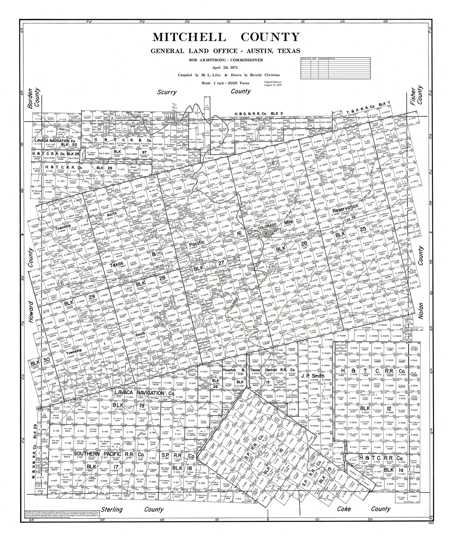
Mitchell County
General Land Office Official County Map
-
Map/Doc
95592
-
Collection
General Map Collection
-
Object Dates
2019/8/31 (Revision Date)
1971/4/26 (Creation Date)
-
People and Organizations
Cheyenne Betancourt (Draftsman)
Beverly Christian (Draftsman)
M. L. Liles (Compiler)
Bob Armstrong (GLO Commissioner)
-
Counties
Mitchell
-
Subjects
County OCM
-
Height x Width
43.6 x 37.0 inches
110.7 x 94.0 cm
-
Medium
digital image
-
Scale
1" = 2000 varas
Part of: General Map Collection
Dimmit County Sketch File 29

Print $40.00
- Digital $50.00
Dimmit County Sketch File 29
1877
Size 26.5 x 22.1 inches
Map/Doc 11351
Harris County Sketch File 49

Print $10.00
- Digital $50.00
Harris County Sketch File 49
1908
Size 11.4 x 9.0 inches
Map/Doc 25446
Montague County

Print $20.00
- Digital $50.00
Montague County
1924
Size 47.9 x 34.7 inches
Map/Doc 95593
Coryell County Working Sketch 30

Print $20.00
- Digital $50.00
Coryell County Working Sketch 30
2001
Size 37.1 x 38.7 inches
Map/Doc 68237
Survey of The Rio Grande Roma to the Gulf of Mexico

Survey of The Rio Grande Roma to the Gulf of Mexico
Map/Doc 81739
Chambers County NRC Article 33.136 Sketch 12

Print $30.00
- Digital $50.00
Chambers County NRC Article 33.136 Sketch 12
2020
Size 24.0 x 35.9 inches
Map/Doc 96441
Reeves County Working Sketch 25

Print $40.00
- Digital $50.00
Reeves County Working Sketch 25
1966
Size 31.4 x 59.0 inches
Map/Doc 63468
McMullen County Sketch File 8

Print $4.00
- Digital $50.00
McMullen County Sketch File 8
1876
Size 8.6 x 8.8 inches
Map/Doc 31349
Dickens County Sketch File H2

Print $4.00
- Digital $50.00
Dickens County Sketch File H2
Size 12.7 x 8.1 inches
Map/Doc 20873
Flight Mission No. CRE-1R, Frame 63, Jackson County

Print $20.00
- Digital $50.00
Flight Mission No. CRE-1R, Frame 63, Jackson County
1956
Size 18.6 x 18.9 inches
Map/Doc 85326
Flight Mission No. DAG-21K, Frame 38, Matagorda County

Print $20.00
- Digital $50.00
Flight Mission No. DAG-21K, Frame 38, Matagorda County
1952
Size 18.6 x 22.3 inches
Map/Doc 86405
Clay County Boundary File 11

Print $12.00
- Digital $50.00
Clay County Boundary File 11
Size 14.0 x 8.4 inches
Map/Doc 51400
You may also like
The Republic County of Milam. Proposed, Late Fall 1837-December 31, 1838

Print $20.00
The Republic County of Milam. Proposed, Late Fall 1837-December 31, 1838
2020
Size 17.4 x 21.6 inches
Map/Doc 96226
Grant and Beales Empresario Colony. October 9, 1832

Print $20.00
Grant and Beales Empresario Colony. October 9, 1832
2020
Size 23.5 x 21.7 inches
Map/Doc 95996
Dallam County Sketch File 13

Print $20.00
- Digital $50.00
Dallam County Sketch File 13
Size 22.2 x 20.3 inches
Map/Doc 11280
Flight Mission No. DCL-6C, Frame 122, Kenedy County

Print $20.00
- Digital $50.00
Flight Mission No. DCL-6C, Frame 122, Kenedy County
1943
Size 18.5 x 22.4 inches
Map/Doc 85952
Kerr County Sketch File 10

Print $6.00
- Digital $50.00
Kerr County Sketch File 10
Size 13.9 x 10.6 inches
Map/Doc 28877
Sterling County Rolled Sketch 28

Print $20.00
- Digital $50.00
Sterling County Rolled Sketch 28
Size 28.8 x 33.4 inches
Map/Doc 7853
Chocolate Bay, West Portion of West Bay and Vicinity, Brazoria and Galveston Counties, showing Subdivision for Mineral Development

Print $40.00
- Digital $50.00
Chocolate Bay, West Portion of West Bay and Vicinity, Brazoria and Galveston Counties, showing Subdivision for Mineral Development
1948
Size 40.7 x 53.9 inches
Map/Doc 1907
Moore County Sketch File 2

Print $36.00
- Digital $50.00
Moore County Sketch File 2
Size 14.2 x 8.6 inches
Map/Doc 31929
[H. & G. N. Block 8 showing Llano and Espuella fence lines]
![90374, [H. & G. N. Block 8 showing Llano and Espuella fence lines], Twichell Survey Records](https://historictexasmaps.com/wmedia_w700/maps/90374-1.tif.jpg)
Print $2.00
- Digital $50.00
[H. & G. N. Block 8 showing Llano and Espuella fence lines]
Size 6.2 x 9.7 inches
Map/Doc 90374
Hutchinson County Working Sketch 18

Print $20.00
- Digital $50.00
Hutchinson County Working Sketch 18
1956
Size 31.4 x 18.3 inches
Map/Doc 66378
Coke County Rolled Sketch 13

Print $40.00
- Digital $50.00
Coke County Rolled Sketch 13
Size 44.5 x 69.9 inches
Map/Doc 8627
Dexter Quadrangle

Print $20.00
- Digital $50.00
Dexter Quadrangle
1999
Size 35.4 x 23.4 inches
Map/Doc 97361