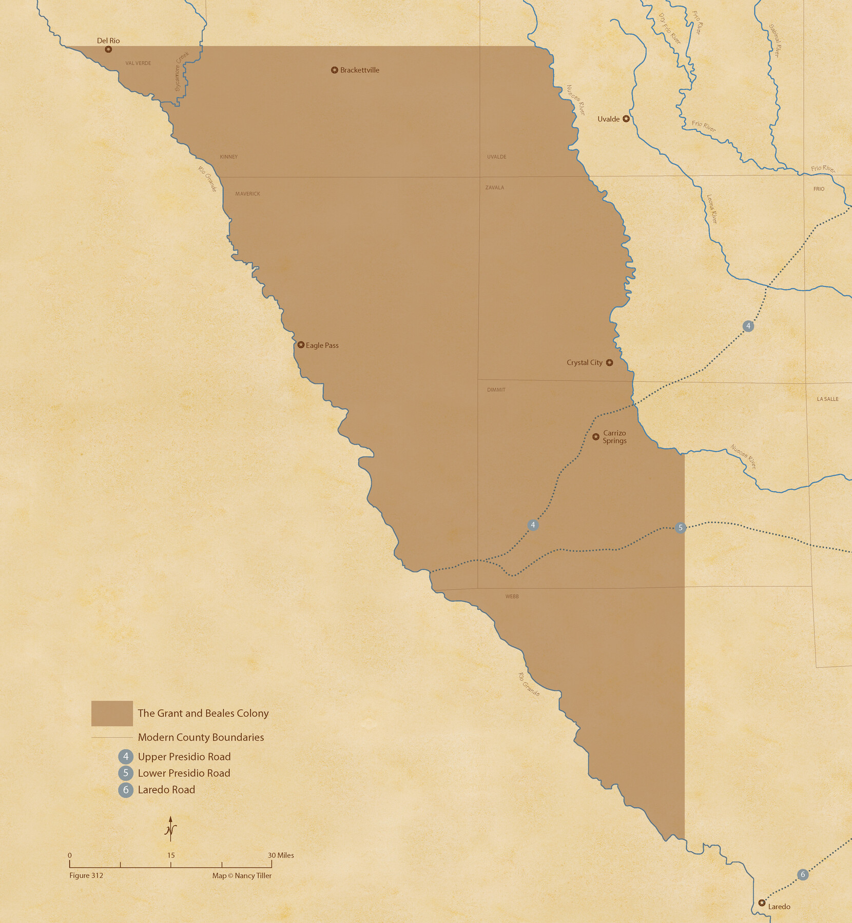
Grant and Beales Empresario Colony. October 9, 1832
Figure No. 312 from 'A Boundary Atlas of Texas, 1821-1845' by Jim Tiller
-
Map/Doc
95996
-
Collection
Nancy and Jim Tiller Digital Collection
-
Object Dates
2020/1/1 (Creation Date)
-
People and Organizations
Jim Tiller (Author)
Nancy Tiller (Cartographer)
Gang Gong (GIS Professional)
-
Subjects
Atlas Colony Mexican Texas Texas Boundaries
-
Height x Width
23.5 x 21.7 inches
59.7 x 55.1 cm
-
Medium
digital image
-
Comments
To purchase a digital PDF copy of "A Boundary Atlas of Texas, 1821-1845" see 96437.
Part of: Nancy and Jim Tiller Digital Collection
The Republic County of Fannin. December 29, 1845

Print $20.00
The Republic County of Fannin. December 29, 1845
2020
Size 12.9 x 21.7 inches
Map/Doc 96130
The Republic County of Colorado. Proposed, Late Fall 1837

Print $20.00
The Republic County of Colorado. Proposed, Late Fall 1837
2020
Size 18.4 x 21.7 inches
Map/Doc 96118
The Republic County of Jackson. September 17, 1838

Print $20.00
The Republic County of Jackson. September 17, 1838
2020
Size 15.6 x 21.8 inches
Map/Doc 96185
The Republic County of Robertson. December 29, 1845

Print $20.00
The Republic County of Robertson. December 29, 1845
2020
Size 16.9 x 21.7 inches
Map/Doc 96264
The Republic County of Galveston. December 16, 1839

Print $20.00
The Republic County of Galveston. December 16, 1839
2020
Size 14.7 x 21.9 inches
Map/Doc 96144
The Republic County of Victoria. September 18, 1838

Print $20.00
The Republic County of Victoria. September 18, 1838
2020
Size 24.3 x 21.7 inches
Map/Doc 96296
The Chief Justice County of Bexar. Lands in Conflict with San Patricio County

Print $20.00
The Chief Justice County of Bexar. Lands in Conflict with San Patricio County
2020
Size 14.7 x 21.6 inches
Map/Doc 96040
The Judicial District/County of Pashcal. Created, January 28, 1841

Print $20.00
The Judicial District/County of Pashcal. Created, January 28, 1841
2020
Size 15.0 x 21.7 inches
Map/Doc 96343
The Judicial District/County of Trinity. Abolished, Spring 1842

Print $20.00
The Judicial District/County of Trinity. Abolished, Spring 1842
2020
Size 14.7 x 21.7 inches
Map/Doc 96351
The Republic County of Nacogdoches. January 16, 1843

Print $20.00
The Republic County of Nacogdoches. January 16, 1843
2020
Size 15.9 x 21.8 inches
Map/Doc 96249
The Republic County of Bexar. December 29, 1845

Print $20.00
The Republic County of Bexar. December 29, 1845
2020
Size 24.6 x 21.6 inches
Map/Doc 96101
The Republic County of Nacogdoches. December 29, 1845

Print $20.00
The Republic County of Nacogdoches. December 29, 1845
2020
Size 15.9 x 21.8 inches
Map/Doc 96250
You may also like
Brewster County Sketch File N-6

Print $40.00
- Digital $50.00
Brewster County Sketch File N-6
1914
Size 15.8 x 12.7 inches
Map/Doc 10963
Terrell County

Print $20.00
- Digital $50.00
Terrell County
1905
Size 41.6 x 30.9 inches
Map/Doc 63061
Cooke County Working Sketch 36

Print $20.00
- Digital $50.00
Cooke County Working Sketch 36
1992
Size 29.0 x 19.6 inches
Map/Doc 68273
Travis County Rolled Sketch 47

Print $40.00
- Digital $50.00
Travis County Rolled Sketch 47
1931
Size 57.2 x 25.4 inches
Map/Doc 10628
Cherokee County Working Sketch 28

Print $20.00
- Digital $50.00
Cherokee County Working Sketch 28
1991
Size 13.7 x 16.8 inches
Map/Doc 67983
[H. & T. C. RR. Company, Block 47, Sections 47- 56 Corrected]
![91412, [H. & T. C. RR. Company, Block 47, Sections 47- 56 Corrected], Twichell Survey Records](https://historictexasmaps.com/wmedia_w700/maps/91412-1.tif.jpg)
Print $2.00
- Digital $50.00
[H. & T. C. RR. Company, Block 47, Sections 47- 56 Corrected]
Size 11.6 x 9.2 inches
Map/Doc 91412
Wichita County Working Sketch 11

Print $20.00
- Digital $50.00
Wichita County Working Sketch 11
1920
Size 32.0 x 18.8 inches
Map/Doc 72520

Austin Empresario Colony. January 17, 1821/February 18, 1823

Print $20.00
Austin Empresario Colony. January 17, 1821/February 18, 1823
2020
Size 18.8 x 21.6 inches
Map/Doc 95978
Montague County

Print $20.00
- Digital $50.00
Montague County
1875
Size 24.6 x 21.1 inches
Map/Doc 3884
Pecos County Working Sketch 12

Print $20.00
- Digital $50.00
Pecos County Working Sketch 12
1912
Size 21.3 x 30.0 inches
Map/Doc 71482
Sabine County Working Sketch 5

Print $20.00
- Digital $50.00
Sabine County Working Sketch 5
1918
Size 17.3 x 17.3 inches
Map/Doc 63676