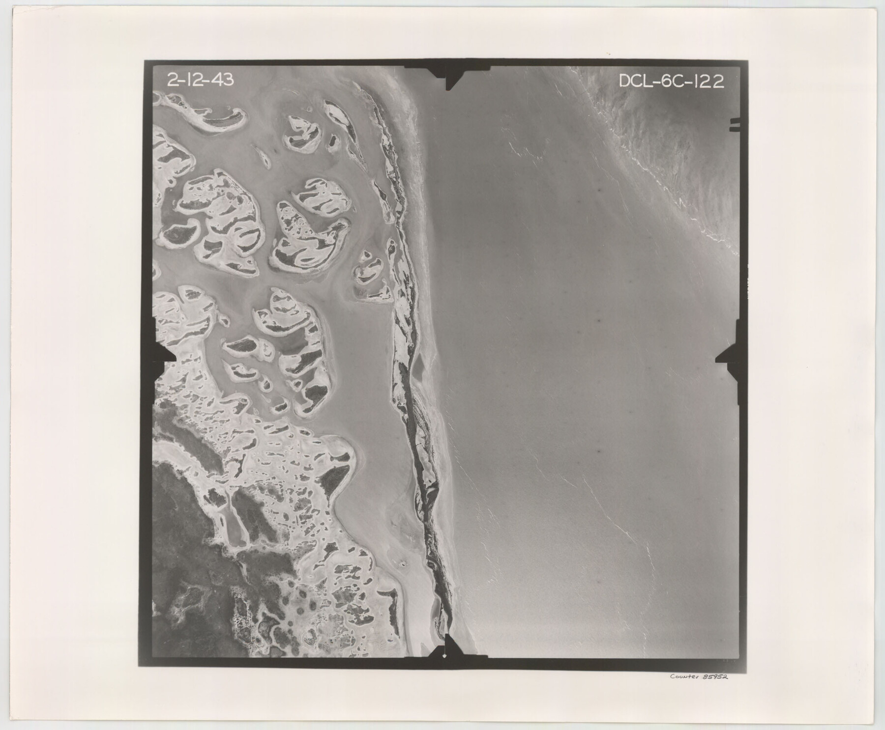
Flight Mission No. DCL-6C, Frame 122, Kenedy County
DCL-6C-122
-
Map/Doc
85952
-
Collection
General Map Collection
-
Object Dates
1943/2/12 (Creation Date)
-
People and Organizations
U. S. Department of Agriculture (Publisher)
-
Counties
Kenedy
-
Subjects
Aerial Photograph
-
Height x Width
18.5 x 22.4 inches
47.0 x 56.9 cm
-
Comments
Flown by Aerial Surveys of Pittsburgh, Inc. of Pittsburgh, Pennsylvania.
Part of: General Map Collection
Burnet County Boundary File 12

Print $14.00
- Digital $50.00
Burnet County Boundary File 12
Size 8.2 x 6.0 inches
Map/Doc 50949
Flight Mission No. DIX-3P, Frame 171, Aransas County

Print $20.00
- Digital $50.00
Flight Mission No. DIX-3P, Frame 171, Aransas County
1956
Size 17.6 x 18.2 inches
Map/Doc 83777
El Paso County Working Sketch 23

Print $20.00
- Digital $50.00
El Paso County Working Sketch 23
1961
Size 22.3 x 28.8 inches
Map/Doc 69045
Hutchinson County Sketch File 45

Print $22.00
- Digital $50.00
Hutchinson County Sketch File 45
1991
Size 11.1 x 8.8 inches
Map/Doc 27354
Map of Comal County

Print $20.00
- Digital $50.00
Map of Comal County
1874
Size 18.4 x 22.3 inches
Map/Doc 3428

Starr County Sketch File 44

Print $8.00
- Digital $50.00
Starr County Sketch File 44
1944
Size 14.1 x 8.8 inches
Map/Doc 36995
Flight Mission No. DQN-5K, Frame 23, Calhoun County

Print $20.00
- Digital $50.00
Flight Mission No. DQN-5K, Frame 23, Calhoun County
1953
Size 18.5 x 22.1 inches
Map/Doc 84374
Coryell County Working Sketch 20

Print $20.00
- Digital $50.00
Coryell County Working Sketch 20
1972
Size 32.2 x 22.4 inches
Map/Doc 68227
Hudspeth County Sketch File 4-5-6

Print $2.00
- Digital $50.00
Hudspeth County Sketch File 4-5-6
Size 8.8 x 8.1 inches
Map/Doc 26891
Cochran County Sketch File 3

Print $4.00
- Digital $50.00
Cochran County Sketch File 3
Size 8.8 x 11.3 inches
Map/Doc 18540
Hardeman County Working Sketch 16

Print $20.00
- Digital $50.00
Hardeman County Working Sketch 16
1982
Size 35.7 x 45.1 inches
Map/Doc 63397
You may also like
Andrews County Working Sketch 17

Print $20.00
- Digital $50.00
Andrews County Working Sketch 17
1963
Size 30.7 x 27.1 inches
Map/Doc 67063
Flight Mission No. DIX-10P, Frame 165, Aransas County

Print $20.00
- Digital $50.00
Flight Mission No. DIX-10P, Frame 165, Aransas County
1956
Size 18.6 x 22.3 inches
Map/Doc 83955
Shelby County Rolled Sketch 11

Print $20.00
- Digital $50.00
Shelby County Rolled Sketch 11
1945
Size 24.9 x 28.6 inches
Map/Doc 7779
Comanche County Working Sketch 4

Print $40.00
- Digital $50.00
Comanche County Working Sketch 4
1919
Size 58.7 x 35.2 inches
Map/Doc 68138
Hutchinson County Working Sketch 11

Print $20.00
- Digital $50.00
Hutchinson County Working Sketch 11
1924
Size 20.4 x 29.4 inches
Map/Doc 66369
Flight Mission No. BRA-16M, Frame 124, Jefferson County

Print $20.00
- Digital $50.00
Flight Mission No. BRA-16M, Frame 124, Jefferson County
1953
Size 18.7 x 22.5 inches
Map/Doc 85734
Photo Index of Texas Coast - Sheet 6 of 6

Print $20.00
- Digital $50.00
Photo Index of Texas Coast - Sheet 6 of 6
1954
Size 20.0 x 24.0 inches
Map/Doc 83444
Map of Wood County Showing Location of the Texas and Pacific Railway

Print $20.00
- Digital $50.00
Map of Wood County Showing Location of the Texas and Pacific Railway
1872
Size 19.1 x 23.8 inches
Map/Doc 64135
The City of Austin and Suburbs

Print $20.00
The City of Austin and Suburbs
1919
Size 24.1 x 19.1 inches
Map/Doc 76203
McLennan County Boundary File 7

Print $8.00
- Digital $50.00
McLennan County Boundary File 7
Size 14.1 x 8.6 inches
Map/Doc 57005
Liberty County Rolled Sketch O

Print $40.00
- Digital $50.00
Liberty County Rolled Sketch O
1954
Size 52.3 x 42.8 inches
Map/Doc 10720
Pecos County Rolled Sketch 146A

Print $37.00
- Digital $50.00
Pecos County Rolled Sketch 146A
1957
Size 10.4 x 15.2 inches
Map/Doc 48396