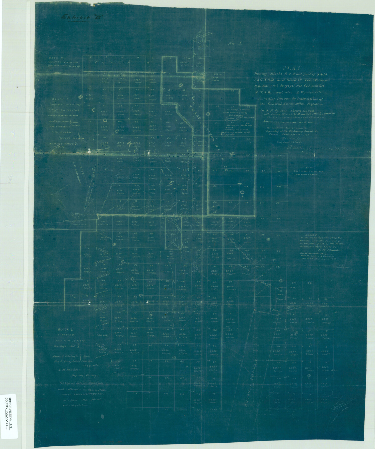
Dimmit County Sketch File 29
A. M. French Sk. of Blks. 6, 7, 8, & pts. of Blks. 9 & 13, I&GN Ry. Co. & Blk. 10 TWNG Ry. Co.
-
Map/Doc
11351
-
Collection
General Map Collection
-
Object Dates
1877 (Creation Date)
1877 (Survey Date)
1877 (Survey Date)
1875 (Survey Date)
-
People and Organizations
A.M. Friend (Surveyor/Engineer)
James S. Fitzhugh (Chainman)
John S. Campbell (Chainman)
F.M. Maddox (Surveyor/Engineer)
Jno. W. Armstrong (Chainman)
Robt. Hutchins (Chainman)
-
Counties
Dimmit Webb
-
Subjects
Surveying Sketch File
-
Height x Width
26.5 x 22.1 inches
67.3 x 56.1 cm
-
Medium
blueprint/diazo
-
Scale
1:2000
-
Features
San Sorento Creek
San Ambrosio Creek
Part of: General Map Collection
Potter County Boundary File 6a

Print $20.00
- Digital $50.00
Potter County Boundary File 6a
Size 43.8 x 15.6 inches
Map/Doc 58039
Texas 1972 Official Highway Travel Map

Digital $50.00
Texas 1972 Official Highway Travel Map
Size 27.9 x 36.0 inches
Map/Doc 94313
Hall County Sketch File 14

Print $20.00
- Digital $50.00
Hall County Sketch File 14
1882
Size 20.9 x 32.9 inches
Map/Doc 11607
Menard County Working Sketch 17

Print $40.00
- Digital $50.00
Menard County Working Sketch 17
1946
Size 59.0 x 42.9 inches
Map/Doc 70964
Hamilton County Working Sketch 19

Print $20.00
- Digital $50.00
Hamilton County Working Sketch 19
1953
Size 45.7 x 23.4 inches
Map/Doc 63357
[Map showing S. A. & A. P. Ry. from San Antonio to Kendall County line]
![64255, [Map showing S. A. & A. P. Ry. from San Antonio to Kendall County line], General Map Collection](https://historictexasmaps.com/wmedia_w700/maps/64255.tif.jpg)
Print $40.00
- Digital $50.00
[Map showing S. A. & A. P. Ry. from San Antonio to Kendall County line]
1895
Size 25.5 x 70.7 inches
Map/Doc 64255
Hall County Sketch File 10

Print $20.00
- Digital $50.00
Hall County Sketch File 10
1884
Size 19.6 x 22.1 inches
Map/Doc 11605
Frio County Working Sketch 5

Print $20.00
- Digital $50.00
Frio County Working Sketch 5
1936
Size 33.9 x 23.0 inches
Map/Doc 69279
Travis County Sketch File 62

Print $20.00
- Digital $50.00
Travis County Sketch File 62
1929
Size 20.6 x 18.2 inches
Map/Doc 12473
Trinity County Sketch File 18 1/2

Print $4.00
- Digital $50.00
Trinity County Sketch File 18 1/2
1876
Size 9.0 x 11.2 inches
Map/Doc 38548
Panola County Rolled Sketch 7

Print $20.00
- Digital $50.00
Panola County Rolled Sketch 7
1957
Size 19.4 x 27.8 inches
Map/Doc 7199
Jeff Davis County Boundary File 1

Print $18.00
- Digital $50.00
Jeff Davis County Boundary File 1
Size 8.8 x 8.6 inches
Map/Doc 55492
You may also like
Falls County Boundary File 1

Print $64.00
- Digital $50.00
Falls County Boundary File 1
Size 9.2 x 4.4 inches
Map/Doc 53241
Flight Mission No. CON-2R, Frame 114, Stonewall County

Print $20.00
- Digital $50.00
Flight Mission No. CON-2R, Frame 114, Stonewall County
1957
Size 18.3 x 22.0 inches
Map/Doc 86989

Kimble County Working Sketch 62

Print $20.00
- Digital $50.00
Kimble County Working Sketch 62
1964
Size 38.0 x 29.7 inches
Map/Doc 70130
Eubank Farm N/2 of NE/4 Section 3, Block D3

Print $20.00
- Digital $50.00
Eubank Farm N/2 of NE/4 Section 3, Block D3
Size 20.9 x 14.0 inches
Map/Doc 92336
Potter County Rolled Sketch 13

Print $20.00
- Digital $50.00
Potter County Rolled Sketch 13
2004
Size 19.2 x 23.2 inches
Map/Doc 82479
Crosby County, Texas

Print $20.00
- Digital $50.00
Crosby County, Texas
Size 17.6 x 19.8 inches
Map/Doc 90355
Goliad County Sketch File 3

Print $4.00
- Digital $50.00
Goliad County Sketch File 3
1852
Size 12.4 x 8.2 inches
Map/Doc 24214
Brewster County Working Sketch 2

Print $20.00
- Digital $50.00
Brewster County Working Sketch 2
1907
Size 29.0 x 26.4 inches
Map/Doc 67535
Winkler County, Texas

Print $20.00
- Digital $50.00
Winkler County, Texas
1889
Size 24.6 x 19.0 inches
Map/Doc 658
Eastland County Working Sketch 46

Print $20.00
- Digital $50.00
Eastland County Working Sketch 46
1980
Size 33.4 x 36.6 inches
Map/Doc 68827
[Surveys along the Leon River and Plum Creek]
![255, [Surveys along the Leon River and Plum Creek], General Map Collection](https://historictexasmaps.com/wmedia_w700/maps/255.tif.jpg)
Print $2.00
- Digital $50.00
[Surveys along the Leon River and Plum Creek]
1846
Size 11.7 x 7.6 inches
Map/Doc 255