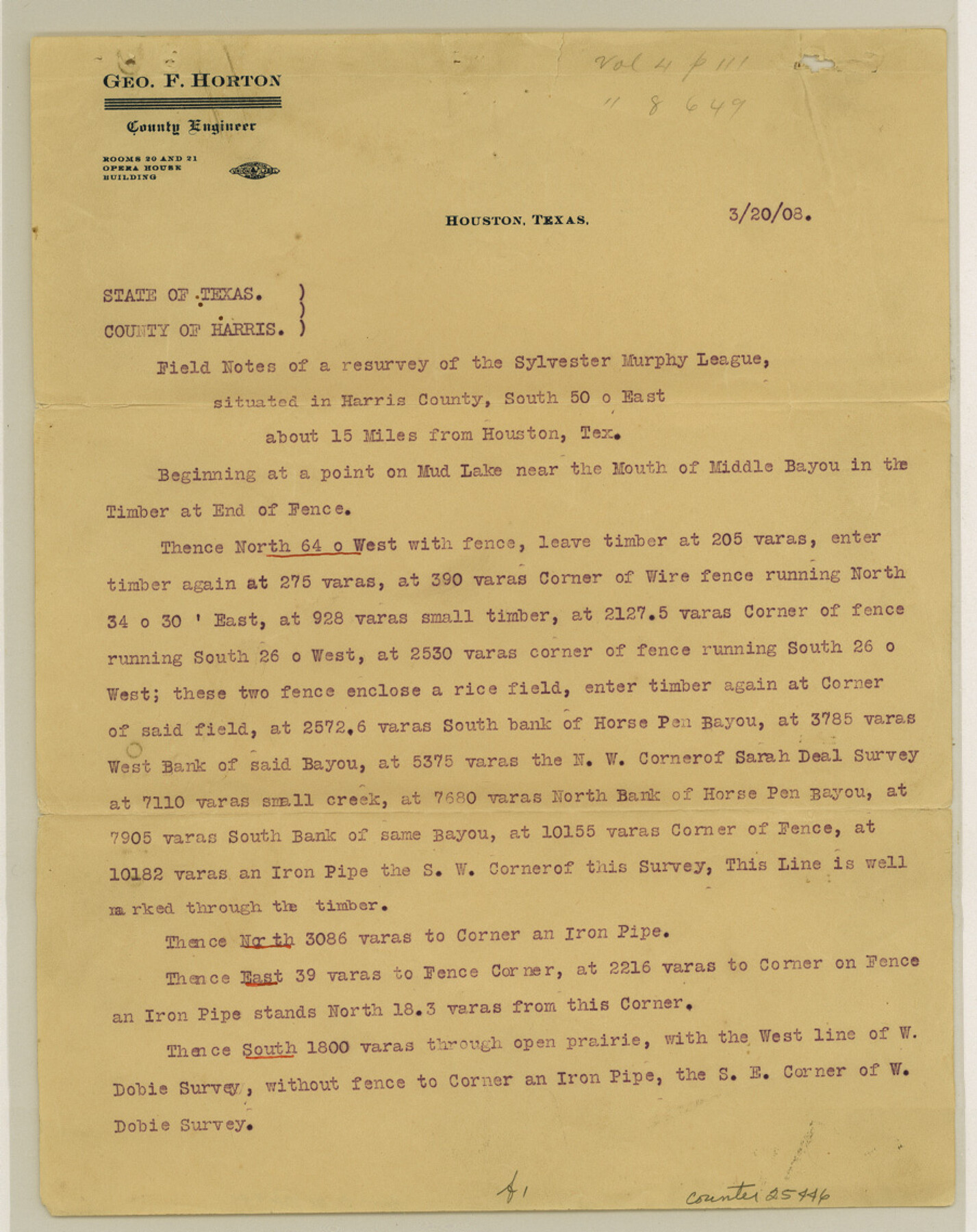
Harris County Sketch File 49
[Corrected field notes of Sylvester Murphy League]
-
Map/Doc
25446
-
Collection
General Map Collection
-
Object Dates
1908/3/20 (Creation Date)
1908/5/20 (File Date)
1908/3/20 (Survey Date)
-
People and Organizations
E. Peperkorn (Surveyor/Engineer)
Charles Williford (Chainman)
John Furlough (Chainman)
-
Counties
Harris
-
Subjects
Surveying Sketch File
-
Height x Width
11.4 x 9.0 inches
29.0 x 22.9 cm
-
Medium
paper, print
-
Features
Mud Lake
Middle Bayou
Horse Pen Bayou
Part of: General Map Collection
Schleicher County Sketch File 3

Print $20.00
- Digital $50.00
Schleicher County Sketch File 3
Size 28.1 x 19.9 inches
Map/Doc 12295
Taylor County Rolled Sketch 27A

Print $20.00
- Digital $50.00
Taylor County Rolled Sketch 27A
Size 30.5 x 21.4 inches
Map/Doc 7919
Stonewall County Rolled Sketch 36B

Print $20.00
- Digital $50.00
Stonewall County Rolled Sketch 36B
Size 35.2 x 22.8 inches
Map/Doc 76404

Kaufman County Boundary File 1a

Print $8.00
- Digital $50.00
Kaufman County Boundary File 1a
Size 14.1 x 8.6 inches
Map/Doc 55907
Comal County Sketch File 4

Print $4.00
- Digital $50.00
Comal County Sketch File 4
Size 6.0 x 8.1 inches
Map/Doc 19004
Upshur County Sketch File 13

Print $4.00
- Digital $50.00
Upshur County Sketch File 13
1861
Size 8.2 x 8.3 inches
Map/Doc 38755
Jefferson County Rolled Sketch 40

Print $20.00
- Digital $50.00
Jefferson County Rolled Sketch 40
1957
Size 22.6 x 36.7 inches
Map/Doc 6398
Cottle County Working Sketch 17

Print $20.00
- Digital $50.00
Cottle County Working Sketch 17
1975
Size 32.5 x 34.1 inches
Map/Doc 68327
Collin County Rolled Sketch 1

Print $20.00
- Digital $50.00
Collin County Rolled Sketch 1
1953
Size 34.9 x 35.6 inches
Map/Doc 8635
Duval County Sketch File 48

Print $8.00
- Digital $50.00
Duval County Sketch File 48
1935
Size 14.2 x 8.8 inches
Map/Doc 21405
Calhoun County Rolled Sketch 12

Print $40.00
- Digital $50.00
Calhoun County Rolled Sketch 12
1940
Size 30.2 x 54.8 inches
Map/Doc 43619
You may also like
Culberson County Working Sketch 3

Print $40.00
- Digital $50.00
Culberson County Working Sketch 3
Size 50.6 x 21.1 inches
Map/Doc 68455
Houston County Sketch File 44

Print $42.00
- Digital $50.00
Houston County Sketch File 44
1847
Size 8.3 x 12.9 inches
Map/Doc 26834
Trinity County Working Sketch Graphic Index

Print $20.00
- Digital $50.00
Trinity County Working Sketch Graphic Index
1946
Size 41.3 x 41.6 inches
Map/Doc 76718

United States - Gulf Coast - From Latitude 26° 33' to the Rio Grande Texas

Print $20.00
- Digital $50.00
United States - Gulf Coast - From Latitude 26° 33' to the Rio Grande Texas
1916
Size 27.9 x 18.3 inches
Map/Doc 72838
Salina Road, Hays' District, Nacogdoches County

Print $2.00
- Digital $50.00
Salina Road, Hays' District, Nacogdoches County
Size 5.1 x 6.2 inches
Map/Doc 174
Flight Mission No. BRE-1P, Frame 74, Nueces County

Print $20.00
- Digital $50.00
Flight Mission No. BRE-1P, Frame 74, Nueces County
1956
Size 18.5 x 22.3 inches
Map/Doc 86656
Flight Mission No. CRE-1R, Frame 193, Jackson County

Print $20.00
- Digital $50.00
Flight Mission No. CRE-1R, Frame 193, Jackson County
1956
Size 18.5 x 22.2 inches
Map/Doc 85347
Howard County Sketch File 12

Print $20.00
- Digital $50.00
Howard County Sketch File 12
1939
Size 18.2 x 15.7 inches
Map/Doc 11799
[Washington County RR. Co. Block 1 and Cherokee Iron Furnace Co. Block 1]
![92065, [Washington County RR. Co. Block 1 and Cherokee Iron Furnace Co. Block 1], Twichell Survey Records](https://historictexasmaps.com/wmedia_w700/maps/92065-1.tif.jpg)
Print $20.00
- Digital $50.00
[Washington County RR. Co. Block 1 and Cherokee Iron Furnace Co. Block 1]
1911
Size 22.4 x 25.4 inches
Map/Doc 92065
Blanco County Working Sketch 23

Print $40.00
- Digital $50.00
Blanco County Working Sketch 23
1962
Size 52.4 x 38.5 inches
Map/Doc 67383
Angelina County Sketch File 28a

Print $14.00
- Digital $50.00
Angelina County Sketch File 28a
1910
Size 6.8 x 8.7 inches
Map/Doc 13080