Moore County Sketch File 2
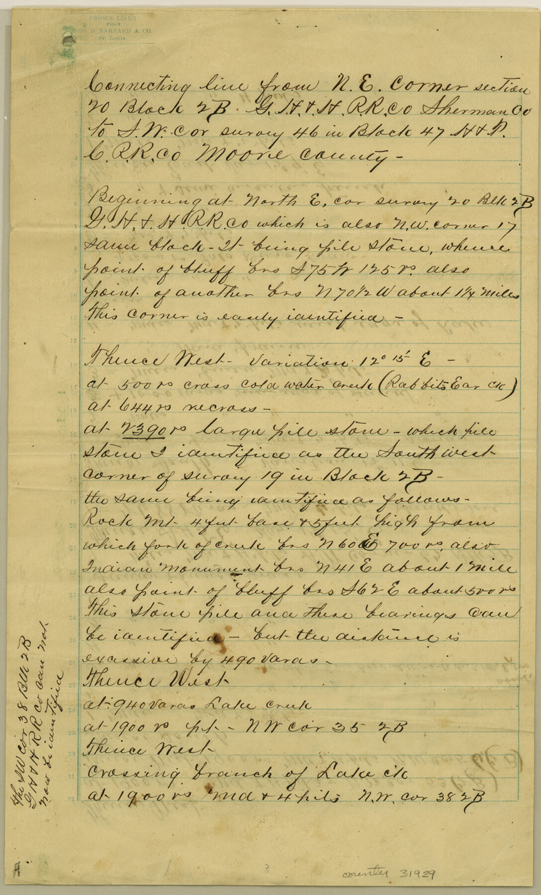
Sketch & Connecting Line From SE Corner No. 19, Block 2B in Sherman County to Stone Pile on West Line No. 46, Block 47, H&TCRRCo., Moore County, Texas
-
Map/Doc
31929
-
Collection
General Map Collection
-
Object Dates
8/23/1888 (File Date)
8/13/1888 (Survey Date)
-
People and Organizations
W.S. Mabry (Surveyor/Engineer)
-
Counties
Moore Sherman
-
Subjects
Surveying Sketch File
-
Height x Width
14.2 x 8.6 inches
36.1 x 21.8 cm
-
Medium
paper, manuscript
-
Features
Cold Water Creek
Rabbit's Ear Creek
Rock Mountain
Lake Creek
Palo Duro Draw
Palo Duro Creek
Bone Lake Road
Old Dodge Road
Round Knob
Big Blue Creek
Little Blue Creek
Hay Creek
Grape Vine Creek
Sand Creek
Pollard Creek
Part of: General Map Collection
Orange County Sketch File 44

Print $4.00
- Digital $50.00
Orange County Sketch File 44
1895
Size 10.9 x 8.8 inches
Map/Doc 33387
Bowie County Sketch File 1

Print $8.00
- Digital $50.00
Bowie County Sketch File 1
Size 8.6 x 10.0 inches
Map/Doc 14833
Sabine County Boundary File 1

Print $96.00
- Digital $50.00
Sabine County Boundary File 1
Size 14.4 x 8.8 inches
Map/Doc 58530
Galveston County Rolled Sketch 50

Print $20.00
- Digital $50.00
Galveston County Rolled Sketch 50
2011
Size 23.9 x 35.8 inches
Map/Doc 95179

Map of the City of Aransas Pass

Print $20.00
- Digital $50.00
Map of the City of Aransas Pass
1905
Size 28.3 x 21.4 inches
Map/Doc 97266
Crane County Sketch File 12

Print $6.00
- Digital $50.00
Crane County Sketch File 12
1901
Size 16.4 x 8.6 inches
Map/Doc 19571
Travis County

Print $40.00
- Digital $50.00
Travis County
1936
Size 46.4 x 54.8 inches
Map/Doc 63076
Rusk County Working Sketch 35

Print $20.00
- Digital $50.00
Rusk County Working Sketch 35
2005
Size 28.7 x 42.0 inches
Map/Doc 83584
Zavala County Sketch File 4

Print $20.00
- Digital $50.00
Zavala County Sketch File 4
1852
Size 17.7 x 14.7 inches
Map/Doc 12726
Gaines County Working Sketch 35

Print $20.00
- Digital $50.00
Gaines County Working Sketch 35
1991
Size 36.4 x 42.8 inches
Map/Doc 69335
Coleman County Sketch File 10

Print $20.00
- Digital $50.00
Coleman County Sketch File 10
1848
Size 28.0 x 13.2 inches
Map/Doc 11119
You may also like
Stephens County Rolled Sketch 3

Print $20.00
- Digital $50.00
Stephens County Rolled Sketch 3
1919
Size 34.9 x 19.6 inches
Map/Doc 7840
[Plat showing well locations]
![91667, [Plat showing well locations], Twichell Survey Records](https://historictexasmaps.com/wmedia_w700/maps/91667-1.tif.jpg)
Print $3.00
- Digital $50.00
[Plat showing well locations]
Size 13.3 x 11.3 inches
Map/Doc 91667
Sterling County Sketch File 23

Print $10.00
- Digital $50.00
Sterling County Sketch File 23
1955
Size 11.2 x 8.8 inches
Map/Doc 37184
[Sections Q, L Tech Memorial Park]
![92303, [Sections Q, L Tech Memorial Park], Twichell Survey Records](https://historictexasmaps.com/wmedia_w700/maps/92303-1.tif.jpg)
Print $20.00
- Digital $50.00
[Sections Q, L Tech Memorial Park]
1956
Size 13.0 x 17.8 inches
Map/Doc 92303
Harris County Working Sketch 75

Print $20.00
- Digital $50.00
Harris County Working Sketch 75
1964
Size 29.7 x 32.3 inches
Map/Doc 65967
Shallow Water Country of Northwest Texas

Shallow Water Country of Northwest Texas
1916
Map/Doc 96758
Stonewall County Working Sketch 12

Print $20.00
- Digital $50.00
Stonewall County Working Sketch 12
1950
Size 27.9 x 27.9 inches
Map/Doc 62319

![4781, Coke Co[unty], General Map Collection](https://historictexasmaps.com/wmedia_w700/maps/4781.tif.jpg)
Right of Way and Track Map, Dayton-Goose Creek Ry. Co., Station 0+00 to Station 190+00

Print $40.00
- Digital $50.00
Right of Way and Track Map, Dayton-Goose Creek Ry. Co., Station 0+00 to Station 190+00
1917
Size 24.8 x 56.6 inches
Map/Doc 64365
Map of Brewster County

Print $20.00
- Digital $50.00
Map of Brewster County
1939
Size 24.5 x 19.5 inches
Map/Doc 3329
Val Verde County Sketch File Z19

Print $26.00
- Digital $50.00
Val Verde County Sketch File Z19
1912
Size 23.1 x 21.1 inches
Map/Doc 12559