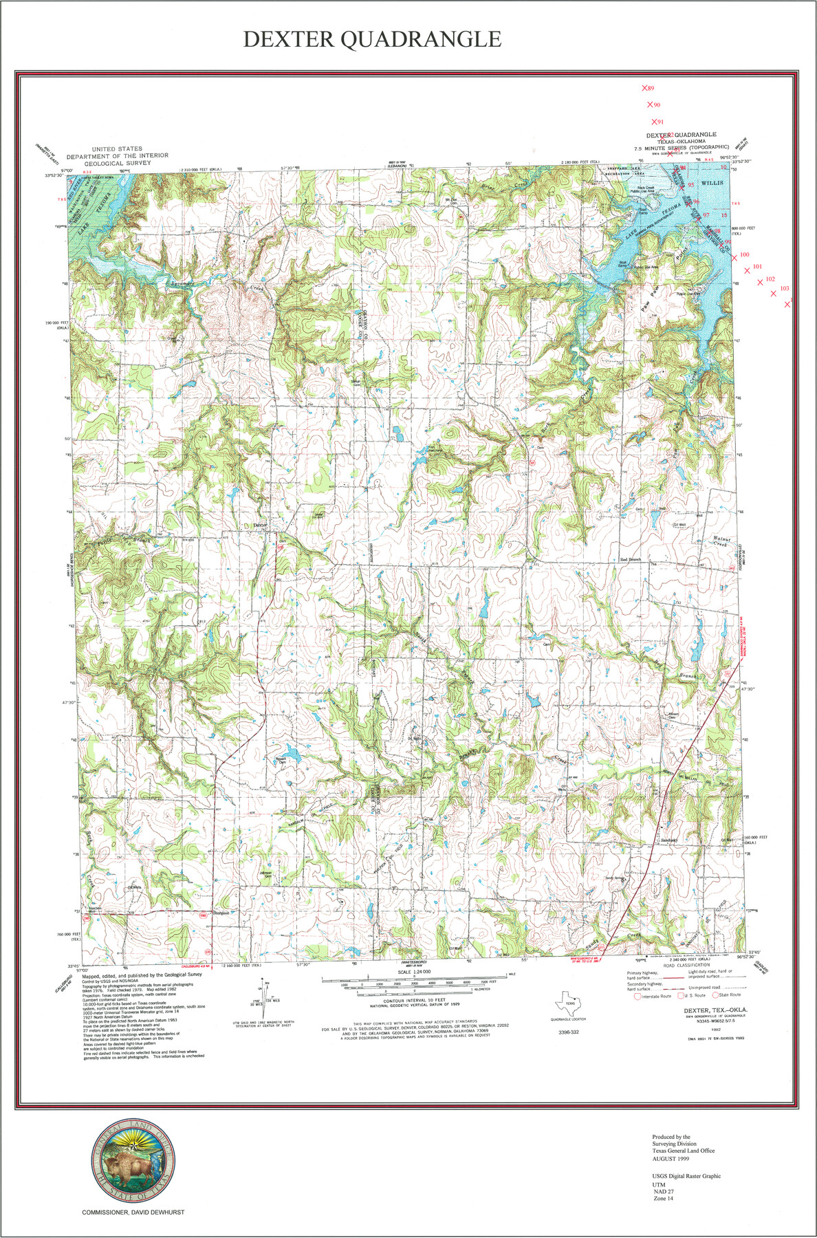
Dexter Quadrangle
USGS Topo Sheet showing plotted Texoma Area Boundary
-
Map/Doc
97361
-
Collection
General Map Collection
-
Object Dates
8/1999 (Creation Date)
-
Counties
Cooke Grayson
-
Subjects
Texas Boundaries Topographic
-
Height x Width
35.4 x 23.4 inches
89.9 x 59.4 cm
-
Comments
See Texas State Boundary Line 7 (75018) and Texas State Boundary Line 10 (97431) for copies of the Texoma Area Boundary Agreement.
Related maps
Texas State Boundary Line 7

Print $182.00
Texas State Boundary Line 7
2000
Size 11.2 x 8.8 inches
Map/Doc 75018
Texas State Boundary Line 8

Print $170.00
Texas State Boundary Line 8
2000
Size 11.3 x 8.8 inches
Map/Doc 75054
Texas State Boundary Line 9

Print $174.00
Texas State Boundary Line 9
2000
Size 11.3 x 8.8 inches
Map/Doc 75076
Lebanon Quadrangle

Print $20.00
- Digital $50.00
Lebanon Quadrangle
1999
Size 35.4 x 23.4 inches
Map/Doc 97360
Gordonville Quadrangle

Print $20.00
- Digital $50.00
Gordonville Quadrangle
1999
Size 35.4 x 23.4 inches
Map/Doc 97362
Pottsboro Quadrangle

Print $20.00
- Digital $50.00
Pottsboro Quadrangle
1999
Size 35.4 x 23.4 inches
Map/Doc 97363
Kingston South Quadrangle

Print $20.00
- Digital $50.00
Kingston South Quadrangle
1999
Size 35.4 x 23.4 inches
Map/Doc 97364
Platter Quadrangle

Print $20.00
- Digital $50.00
Platter Quadrangle
1999
Size 35.4 x 23.4 inches
Map/Doc 97365
Denison Dam Quadrangle

Print $20.00
- Digital $50.00
Denison Dam Quadrangle
1999
Size 35.4 x 23.4 inches
Map/Doc 97366

Part of: General Map Collection
Zapata County Rolled Sketch 7A

Print $20.00
- Digital $50.00
Zapata County Rolled Sketch 7A
1912
Size 17.9 x 26.6 inches
Map/Doc 8309
Irion County Rolled Sketch 10

Print $20.00
- Digital $50.00
Irion County Rolled Sketch 10
1942
Size 29.8 x 29.1 inches
Map/Doc 6322
Eastland County Working Sketch 11

Print $20.00
- Digital $50.00
Eastland County Working Sketch 11
1919
Size 20.2 x 16.7 inches
Map/Doc 68792

San Jacinto County Working Sketch Graphic Index

Print $20.00
- Digital $50.00
San Jacinto County Working Sketch Graphic Index
1942
Size 44.9 x 40.6 inches
Map/Doc 76691
Gulf Intracoastal Waterway - Tributary Channel to Aransas Pass, Location of Spoil Disposal Areas

Print $20.00
- Digital $50.00
Gulf Intracoastal Waterway - Tributary Channel to Aransas Pass, Location of Spoil Disposal Areas
1961
Size 31.5 x 41.9 inches
Map/Doc 61828
Zavala County Sketch File 1

Print $20.00
- Digital $50.00
Zavala County Sketch File 1
Size 28.5 x 22.7 inches
Map/Doc 12725
Polk County Working Sketch 22

Print $40.00
- Digital $50.00
Polk County Working Sketch 22
1957
Size 43.0 x 64.6 inches
Map/Doc 71637
Kinney County Working Sketch 8

Print $20.00
- Digital $50.00
Kinney County Working Sketch 8
1913
Size 19.4 x 15.1 inches
Map/Doc 70190
Garza County Sketch File B

Print $20.00
- Digital $50.00
Garza County Sketch File B
1898
Size 19.3 x 29.4 inches
Map/Doc 11549
Burleson County Working Sketch 21

Print $20.00
- Digital $50.00
Burleson County Working Sketch 21
1980
Size 16.4 x 12.7 inches
Map/Doc 67740
The Texas Co-Ordinate System, Title 86 Art. 5300A

Print $20.00
- Digital $50.00
The Texas Co-Ordinate System, Title 86 Art. 5300A
1943
Size 27.7 x 30.3 inches
Map/Doc 3122
You may also like
Nueces County Sketch File 47

Print $17.00
- Digital $50.00
Nueces County Sketch File 47
Size 14.3 x 8.5 inches
Map/Doc 32655
Aransas County Rolled Sketch 15

Print $20.00
- Digital $50.00
Aransas County Rolled Sketch 15
1889
Size 39.3 x 38.0 inches
Map/Doc 78223
Morris County Rolled Sketch 2A

Print $20.00
- Digital $50.00
Morris County Rolled Sketch 2A
Size 24.0 x 18.8 inches
Map/Doc 10238
Shackelford County Working Sketch 13

Print $20.00
- Digital $50.00
Shackelford County Working Sketch 13
1999
Size 18.6 x 16.2 inches
Map/Doc 63853
Hamilton Dam, Reservoir Clearing

Print $4.00
- Digital $50.00
Hamilton Dam, Reservoir Clearing
1936
Size 10.5 x 28.9 inches
Map/Doc 2096
Edwards County Sketch File VII

Print $8.00
- Digital $50.00
Edwards County Sketch File VII
1912
Size 8.8 x 4.1 inches
Map/Doc 21668
Pecos County Rolled Sketch 69

Print $20.00
- Digital $50.00
Pecos County Rolled Sketch 69
Size 37.9 x 33.8 inches
Map/Doc 9701
Cooke County Sketch File 13

Print $20.00
- Digital $50.00
Cooke County Sketch File 13
1859
Size 27.1 x 19.0 inches
Map/Doc 11171
Ector County Working Sketch 27

Print $20.00
- Digital $50.00
Ector County Working Sketch 27
Size 28.0 x 32.7 inches
Map/Doc 68870
Montgomery County Working Sketch 70

Print $20.00
- Digital $50.00
Montgomery County Working Sketch 70
1973
Size 41.3 x 31.7 inches
Map/Doc 71177
Jeff Davis County Rolled Sketch 38

Print $20.00
- Digital $50.00
Jeff Davis County Rolled Sketch 38
1994
Size 26.1 x 35.1 inches
Map/Doc 6381
Kaufman County Working Sketch 9

Print $20.00
- Digital $50.00
Kaufman County Working Sketch 9
1988
Size 35.9 x 29.8 inches
Map/Doc 66672