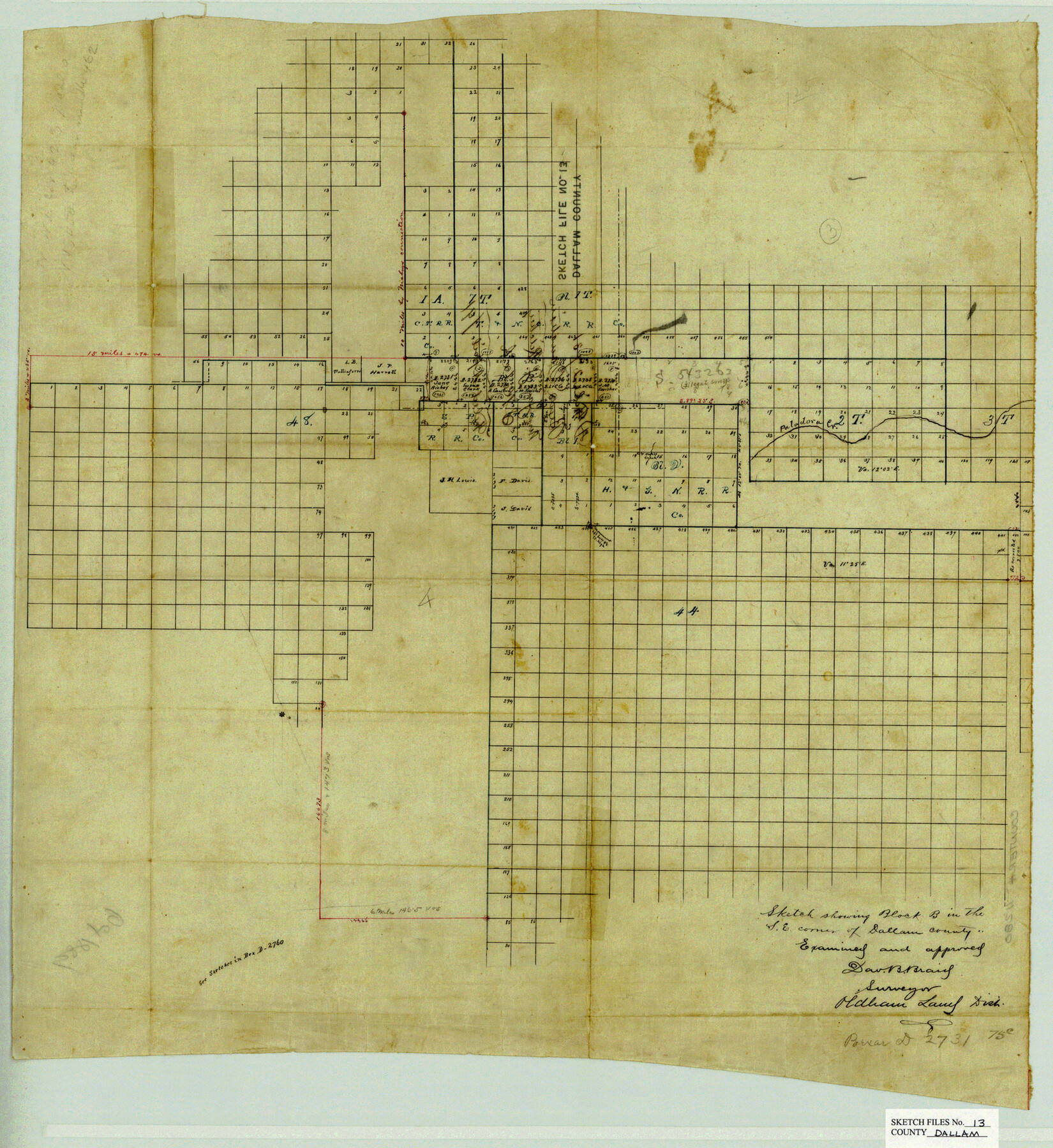
Dallam County Sketch File 13
Sketch showing Block B in the S. E. corner of Dallam County
-
Map/Doc
11280
-
Collection
General Map Collection
-
Object Dates
1891 (File Date)
-
People and Organizations
Dav. B. Braid (Surveyor/Engineer)
-
Counties
Dallam Hartley Moore Sherman
-
Subjects
Surveying Sketch File
-
Height x Width
22.2 x 20.3 inches
56.4 x 51.6 cm
-
Medium
paper, manuscript
-
Features
Paladora Creek
Part of: General Map Collection
Matagorda Light to Aransas Pass

Print $20.00
- Digital $50.00
Matagorda Light to Aransas Pass
1935
Size 35.1 x 44.2 inches
Map/Doc 73393
[Sketch for Mineral Application 16696-16697, Pecos River]
![65613, [Sketch for Mineral Application 16696-16697, Pecos River], General Map Collection](https://historictexasmaps.com/wmedia_w700/maps/65613-1.tif.jpg)
Print $40.00
- Digital $50.00
[Sketch for Mineral Application 16696-16697, Pecos River]
Size 36.7 x 68.3 inches
Map/Doc 65613
Aransas County Rolled Sketch 28

Print $20.00
- Digital $50.00
Aransas County Rolled Sketch 28
1987
Size 24.5 x 30.9 inches
Map/Doc 77496
Guadalupe County Sketch File 15f

Print $10.00
- Digital $50.00
Guadalupe County Sketch File 15f
Size 12.7 x 8.2 inches
Map/Doc 24710
Kimble County Working Sketch 94

Print $20.00
- Digital $50.00
Kimble County Working Sketch 94
1993
Size 28.3 x 33.7 inches
Map/Doc 70162
Right-of-Way and Track Map, Houston and Brazos Valley Ry. Co. operated by the Houston and Brazos Valley Ry. Co.

Print $40.00
- Digital $50.00
Right-of-Way and Track Map, Houston and Brazos Valley Ry. Co. operated by the Houston and Brazos Valley Ry. Co.
1918
Size 24.9 x 56.4 inches
Map/Doc 64602
Jefferson County Rolled Sketch 36

Print $20.00
- Digital $50.00
Jefferson County Rolled Sketch 36
1957
Size 41.1 x 29.1 inches
Map/Doc 6395
Hood County Sketch File 4

Print $4.00
- Digital $50.00
Hood County Sketch File 4
Size 8.8 x 7.8 inches
Map/Doc 26575
Harris County Sketch File 66

Print $20.00
- Digital $50.00
Harris County Sketch File 66
Size 16.9 x 27.5 inches
Map/Doc 11661
Travis County Sketch File 73

Print $8.00
- Digital $50.00
Travis County Sketch File 73
1848
Size 12.8 x 8.3 inches
Map/Doc 38464
Harris County Rolled Sketch 7b

Print $20.00
- Digital $50.00
Harris County Rolled Sketch 7b
Size 47.8 x 42.4 inches
Map/Doc 9853
Maverick County Rolled Sketch 23

Print $91.00
- Digital $50.00
Maverick County Rolled Sketch 23
1965
Size 9.5 x 14.8 inches
Map/Doc 46786
You may also like
Flight Mission No. BRA-16M, Frame 67, Jefferson County

Print $20.00
- Digital $50.00
Flight Mission No. BRA-16M, Frame 67, Jefferson County
1953
Size 18.6 x 22.4 inches
Map/Doc 85684
Val Verde County Sketch File AA3

Print $20.00
- Digital $50.00
Val Verde County Sketch File AA3
1924
Size 19.5 x 20.6 inches
Map/Doc 12540
Montgomery County Rolled Sketch 42

Print $20.00
- Digital $50.00
Montgomery County Rolled Sketch 42
1939
Size 14.2 x 20.5 inches
Map/Doc 6817
Jefferson County Rolled Sketch 39

Print $20.00
- Digital $50.00
Jefferson County Rolled Sketch 39
1885
Size 31.6 x 34.3 inches
Map/Doc 9300
Loving County Rolled Sketch 4

Print $40.00
- Digital $50.00
Loving County Rolled Sketch 4
1952
Size 82.2 x 19.5 inches
Map/Doc 9465
Tyler County Sketch File 23

Print $20.00
- Digital $50.00
Tyler County Sketch File 23
Size 25.3 x 20.9 inches
Map/Doc 12500
Intracoastal Waterway in Texas - Corpus Christi to Point Isabel including Arroyo Colorado to Mo. Pac. R.R. Bridge Near Harlingen

Print $20.00
- Digital $50.00
Intracoastal Waterway in Texas - Corpus Christi to Point Isabel including Arroyo Colorado to Mo. Pac. R.R. Bridge Near Harlingen
1933
Size 27.7 x 40.8 inches
Map/Doc 61867
Cameron County Aerial Photograph Index Sheet 8

Print $20.00
- Digital $50.00
Cameron County Aerial Photograph Index Sheet 8
1955
Size 20.4 x 16.1 inches
Map/Doc 83680
General Highway Map, Jackson County, Texas

Print $20.00
General Highway Map, Jackson County, Texas
1940
Size 18.3 x 24.8 inches
Map/Doc 79140
Harrison County Working Sketch Graphic Index

Print $20.00
- Digital $50.00
Harrison County Working Sketch Graphic Index
1920
Size 44.9 x 41.7 inches
Map/Doc 76570
Liberty County Working Sketch 84

Print $20.00
- Digital $50.00
Liberty County Working Sketch 84
1981
Size 21.3 x 18.4 inches
Map/Doc 70544
Lubbock County Working Sketch 2

Print $20.00
- Digital $50.00
Lubbock County Working Sketch 2
Size 31.7 x 21.4 inches
Map/Doc 70661