Coke County Rolled Sketch 13
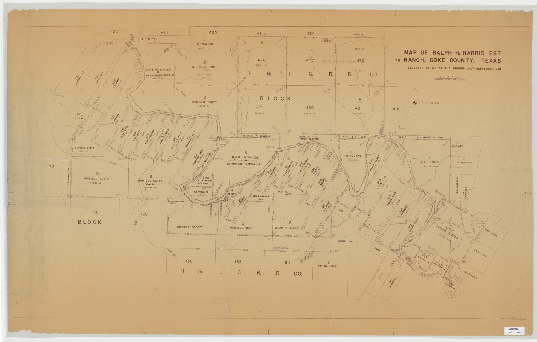
Map of Ralph H. Harris Est. Ranch, Coke County, Texas
-
Map/Doc
8627
-
Collection
General Map Collection
-
Object Dates
1950/2/1 (File Date)
1948 (Survey Date)
-
People and Organizations
Byron L. Simpson (Surveyor/Engineer)
-
Counties
Coke
-
Subjects
Surveying Rolled Sketch
-
Height x Width
44.5 x 69.9 inches
113.0 x 177.5 cm
-
Medium
van dyke/brownline/sepia
-
Scale
1" = 300 varas
Part of: General Map Collection
Baylor County Sketch File A

Print $6.00
- Digital $50.00
Baylor County Sketch File A
Size 7.5 x 9.2 inches
Map/Doc 14072
Bailey County Sketch File 3a

Print $12.00
- Digital $50.00
Bailey County Sketch File 3a
1901
Size 8.1 x 9.0 inches
Map/Doc 13948
Bee County Rolled Sketch 1

Print $20.00
- Digital $50.00
Bee County Rolled Sketch 1
2022
Size 24.4 x 36.0 inches
Map/Doc 97029
Wilbarger County Sketch File 8

Print $4.00
- Digital $50.00
Wilbarger County Sketch File 8
1885
Size 14.2 x 8.6 inches
Map/Doc 40179
Borden County Sketch File 11

Print $4.00
- Digital $50.00
Borden County Sketch File 11
1892
Size 11.0 x 8.9 inches
Map/Doc 14730
Map of Gregg County

Print $20.00
- Digital $50.00
Map of Gregg County
1874
Size 14.0 x 13.9 inches
Map/Doc 3604
Harrison County Working Sketch 7

Print $20.00
- Digital $50.00
Harrison County Working Sketch 7
1955
Size 32.0 x 39.0 inches
Map/Doc 66027
Parker County Sketch File 10

Print $40.00
- Digital $50.00
Parker County Sketch File 10
Size 43.5 x 37.8 inches
Map/Doc 10567
Ector County Rolled Sketch 11

Print $20.00
- Digital $50.00
Ector County Rolled Sketch 11
1947
Size 47.5 x 38.8 inches
Map/Doc 8839
Medina County

Print $40.00
- Digital $50.00
Medina County
1976
Size 52.5 x 43.2 inches
Map/Doc 73237
Webb County Sketch File 7

Print $40.00
- Digital $50.00
Webb County Sketch File 7
1877
Size 13.7 x 14.3 inches
Map/Doc 39739
Childress County

Print $20.00
- Digital $50.00
Childress County
1892
Size 24.7 x 19.6 inches
Map/Doc 3391
You may also like
Falls County Sketch File 27

Print $6.00
- Digital $50.00
Falls County Sketch File 27
Size 16.1 x 11.0 inches
Map/Doc 22436
Baylor County Boundary File 17

Print $20.00
- Digital $50.00
Baylor County Boundary File 17
Size 20.0 x 7.7 inches
Map/Doc 50434
Flight Mission No. DQN-2K, Frame 71, Calhoun County

Print $20.00
- Digital $50.00
Flight Mission No. DQN-2K, Frame 71, Calhoun County
1953
Size 18.9 x 22.4 inches
Map/Doc 84263
Map of Walker County

Print $20.00
- Digital $50.00
Map of Walker County
1858
Size 22.9 x 34.1 inches
Map/Doc 4120
[Sketch showing unsurveyed land in West Texas as of 1902]
![89937, [Sketch showing unsurveyed land in West Texas as of 1902], Twichell Survey Records](https://historictexasmaps.com/wmedia_w700/maps/89937-1.tif.jpg)
Print $20.00
- Digital $50.00
[Sketch showing unsurveyed land in West Texas as of 1902]
Size 42.0 x 34.0 inches
Map/Doc 89937
Lubbock County

Print $20.00
- Digital $50.00
Lubbock County
1968
Size 43.5 x 35.4 inches
Map/Doc 77359
Val Verde County Rolled Sketch 33

Print $20.00
- Digital $50.00
Val Verde County Rolled Sketch 33
1891
Size 27.8 x 28.2 inches
Map/Doc 8112
Bee County Boundary File 7

Print $8.00
- Digital $50.00
Bee County Boundary File 7
Size 12.7 x 8.1 inches
Map/Doc 50460
McMullen County Sketch File 23

Print $4.00
- Digital $50.00
McMullen County Sketch File 23
1876
Size 10.0 x 8.0 inches
Map/Doc 31379
Map Showing the position of surveys 1 & 2, B.S. & F. Cert 1/356

Print $20.00
- Digital $50.00
Map Showing the position of surveys 1 & 2, B.S. & F. Cert 1/356
1915
Size 22.0 x 11.1 inches
Map/Doc 10768
Texas Coast, No. 17

Print $20.00
- Digital $50.00
Texas Coast, No. 17
Size 18.3 x 27.6 inches
Map/Doc 72712
Map of Texas. The Proposed Reoccupation of the Rio Grande -- Its Importance to the Union

Print $20.00
Map of Texas. The Proposed Reoccupation of the Rio Grande -- Its Importance to the Union
1863
Size 14.1 x 8.7 inches
Map/Doc 76263