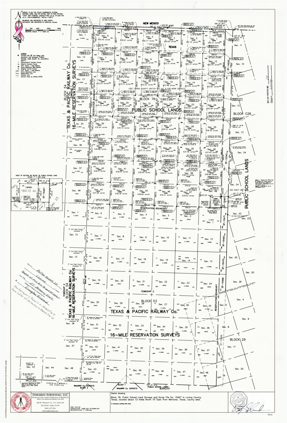
Loving County Rolled Sketch 16
Sketch showing Block 76, Public School Land surveys and Scrap File No. 15467 in Loving County, Texas
-
Map/Doc
94114
-
Collection
General Map Collection
-
Object Dates
12/6/2016 (Creation Date)
1/17/2017 (File Date)
10/2016 (Survey Date)
-
People and Organizations
Wm. Davey Edwards, PhD (Surveyor/Engineer)
-
Counties
Loving
-
Subjects
Surveying Rolled Sketch
-
Height x Width
36.3 x 24.6 inches
92.2 x 62.5 cm
-
Medium
mylar, print
-
Scale
1" = 1000 varas
-
Comments
See surveyor's report in Loving County Sketch File 9 (93794). See letter of correction in Loving County Sketch File 10 (94115).
Related maps
Loving County Sketch File 9

Print $36.00
- Digital $50.00
Loving County Sketch File 9
2015
Size 14.0 x 8.5 inches
Map/Doc 93794
Loving County Sketch File 10

Print $2.00
- Digital $50.00
Loving County Sketch File 10
2016
Size 11.0 x 8.5 inches
Map/Doc 94115
Loving County Rolled Sketch 17

Print $40.00
- Digital $50.00
Loving County Rolled Sketch 17
2022
Size 38.2 x 49.3 inches
Map/Doc 97292
Part of: General Map Collection
[Map of the Line of the H. & Texas Cen. Railway from the Navasota River, 72 1/2 Miles from Houston, to Corsicana in Navarro Co., 211 mls from Houston]
![64087, [Map of the Line of the H. & Texas Cen. Railway from the Navasota River, 72 1/2 Miles from Houston, to Corsicana in Navarro Co., 211 mls from Houston], General Map Collection](https://historictexasmaps.com/wmedia_w700/maps/64087.tif.jpg)
Print $40.00
- Digital $50.00
[Map of the Line of the H. & Texas Cen. Railway from the Navasota River, 72 1/2 Miles from Houston, to Corsicana in Navarro Co., 211 mls from Houston]
Size 75.6 x 39.6 inches
Map/Doc 64087
Chambers County Sketch File 46

Print $356.00
- Digital $50.00
Chambers County Sketch File 46
1927
Size 20.7 x 7.3 inches
Map/Doc 17751
Bexar County Sketch File 36

Print $14.00
- Digital $50.00
Bexar County Sketch File 36
1868
Size 8.8 x 7.6 inches
Map/Doc 14500
Borden County Working Sketch 1a and 1b

Print $20.00
- Digital $50.00
Borden County Working Sketch 1a and 1b
1890
Size 16.2 x 18.0 inches
Map/Doc 67461

Flight Mission No. CUG-3P, Frame 31, Kleberg County

Print $20.00
- Digital $50.00
Flight Mission No. CUG-3P, Frame 31, Kleberg County
1956
Size 18.5 x 22.4 inches
Map/Doc 86236
Cottle County Rolled Sketch 12

Print $20.00
- Digital $50.00
Cottle County Rolled Sketch 12
1959
Size 41.1 x 30.9 inches
Map/Doc 5570
Kenedy County Boundary File 2

Print $22.00
- Digital $50.00
Kenedy County Boundary File 2
Size 11.2 x 8.6 inches
Map/Doc 55782
San Patricio County NRC Article 33.136 Sketch 6

Print $24.00
- Digital $50.00
San Patricio County NRC Article 33.136 Sketch 6
2010
Size 22.0 x 34.0 inches
Map/Doc 94472
Bexar County Sketch File 7

Print $4.00
- Digital $50.00
Bexar County Sketch File 7
1861
Size 8.0 x 12.9 inches
Map/Doc 14475
Houston County Sketch File 18

Print $4.00
- Digital $50.00
Houston County Sketch File 18
Size 4.8 x 10.3 inches
Map/Doc 26781
University Lands Blocks 29-33, Crockett County, Texas

Print $20.00
- Digital $50.00
University Lands Blocks 29-33, Crockett County, Texas
1936
Size 29.8 x 42.7 inches
Map/Doc 2443
You may also like
Parker County Working Sketch 19-1

Print $20.00
- Digital $50.00
Parker County Working Sketch 19-1
2004
Map/Doc 83579
[County Line between DeWitt and Lavaca Counties]
![65355, [County Line between DeWitt and Lavaca Counties], General Map Collection](https://historictexasmaps.com/wmedia_w700/pdf_converted_jpg/qi_pdf_thumbnail_19782.jpg)
Print $226.00
- Digital $50.00
[County Line between DeWitt and Lavaca Counties]
1906
Size 17.4 x 34.4 inches
Map/Doc 65355
Bee County Working Sketch 31a

Print $20.00
- Digital $50.00
Bee County Working Sketch 31a
1988
Size 39.5 x 43.2 inches
Map/Doc 76052
[Sketch for Mineral Application 26501 - Sabine River, T. A. Oldhausen]
![2839, [Sketch for Mineral Application 26501 - Sabine River, T. A. Oldhausen], General Map Collection](https://historictexasmaps.com/wmedia_w700/maps/2839.tif.jpg)
Print $20.00
- Digital $50.00
[Sketch for Mineral Application 26501 - Sabine River, T. A. Oldhausen]
1931
Size 17.7 x 36.4 inches
Map/Doc 2839
Chambers County NRC Article 33.136 Sketch 6

Print $58.00
- Digital $50.00
Chambers County NRC Article 33.136 Sketch 6
2007
Size 11.0 x 8.5 inches
Map/Doc 88802
Calhoun County NRC Article 33.136 Sketch 13

Print $24.00
Calhoun County NRC Article 33.136 Sketch 13
2023
Map/Doc 97272
Gulf Oil Corp. Fishgide - Port Isabel

Gulf Oil Corp. Fishgide - Port Isabel
1960
Size 12.1 x 22.4 inches
Map/Doc 75981
Flight Mission No. BRE-2P, Frame 50, Nueces County

Print $20.00
- Digital $50.00
Flight Mission No. BRE-2P, Frame 50, Nueces County
1956
Size 18.5 x 22.4 inches
Map/Doc 86752
Flight Mission No. BRE-1P, Frame 140, Nueces County

Print $20.00
- Digital $50.00
Flight Mission No. BRE-1P, Frame 140, Nueces County
1956
Size 18.8 x 22.7 inches
Map/Doc 86700
Crane County Working Sketch 25

Print $20.00
- Digital $50.00
Crane County Working Sketch 25
1969
Size 33.0 x 26.3 inches
Map/Doc 68302
A New Map of Texas with the contiguous American and Mexican States

Print $20.00
- Digital $50.00
A New Map of Texas with the contiguous American and Mexican States
1839
Size 13.0 x 15.4 inches
Map/Doc 96513
[S.E. corner of Sec. 48, Blk. 35 T5N to N.E. corner of Sec. 1, Blk. 35 T5N]
![89826, [S.E. corner of Sec. 48, Blk. 35 T5N to N.E. corner of Sec. 1, Blk. 35 T5N], Twichell Survey Records](https://historictexasmaps.com/wmedia_w700/maps/89826-1.tif.jpg)
Print $40.00
- Digital $50.00
[S.E. corner of Sec. 48, Blk. 35 T5N to N.E. corner of Sec. 1, Blk. 35 T5N]
1907
Size 7.2 x 72.9 inches
Map/Doc 89826