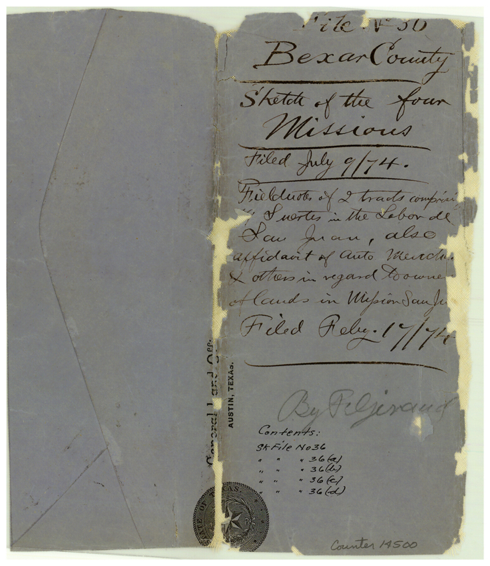
Bexar County Sketch File 36
[Field notes of two tracts containing 19 suertes in the Labor de San Juan]
-
Map/Doc
14500
-
Collection
General Map Collection
-
Object Dates
1868/5/1 (Creation Date)
1874/2/17 (File Date)
-
People and Organizations
F. Giraud (Surveyor/Engineer)
-
Counties
Bexar
-
Subjects
Surveying Sketch File
-
Height x Width
8.8 x 7.6 inches
22.4 x 19.3 cm
-
Medium
paper, manuscript
-
Features
San Juan Capistrano Mission
San Antonio de Bexar
San Antonio River
San Juan Ditch
Arroyo de las Coloradas
Part of: General Map Collection
Foard County Sketch File 34

Print $20.00
- Digital $50.00
Foard County Sketch File 34
1889
Size 29.1 x 24.9 inches
Map/Doc 11497
Matagorda Bay and Approaches

Print $20.00
- Digital $50.00
Matagorda Bay and Approaches
1931
Size 34.9 x 44.4 inches
Map/Doc 73378
Louisiana and Texas Intracoastal Waterway Proposed Extension to Rio Grande Valley

Print $20.00
- Digital $50.00
Louisiana and Texas Intracoastal Waterway Proposed Extension to Rio Grande Valley
1941
Size 28.1 x 41.1 inches
Map/Doc 61891
Kendall County Boundary File 54

Print $16.00
- Digital $50.00
Kendall County Boundary File 54
Size 8.6 x 3.5 inches
Map/Doc 55769
PSL Field Notes for Blocks 77, B2, B3, and A56 in Winkler County

PSL Field Notes for Blocks 77, B2, B3, and A56 in Winkler County
Map/Doc 81679
Johnson County Boundary File 1

Print $66.00
- Digital $50.00
Johnson County Boundary File 1
Size 14.1 x 8.5 inches
Map/Doc 55551
Pecos County Rolled Sketch 163

Print $20.00
- Digital $50.00
Pecos County Rolled Sketch 163
Size 28.2 x 23.9 inches
Map/Doc 7286
Goliad County Sketch File 12

Print $18.00
- Digital $50.00
Goliad County Sketch File 12
1857
Size 12.9 x 7.9 inches
Map/Doc 24230

Orange County Rolled Sketch 27

Print $20.00
- Digital $50.00
Orange County Rolled Sketch 27
1954
Size 22.3 x 34.5 inches
Map/Doc 7186
Flight Mission No. BRA-9M, Frame 60, Jefferson County

Print $20.00
- Digital $50.00
Flight Mission No. BRA-9M, Frame 60, Jefferson County
1953
Size 18.6 x 22.4 inches
Map/Doc 85643
Garza County Rolled Sketch 11

Print $20.00
- Digital $50.00
Garza County Rolled Sketch 11
1915
Size 31.6 x 20.8 inches
Map/Doc 6000
You may also like
Map of San Patricio County

Print $40.00
- Digital $50.00
Map of San Patricio County
1840
Size 48.7 x 57.2 inches
Map/Doc 77095
Shelby County Rolled Sketch 13

Print $20.00
- Digital $50.00
Shelby County Rolled Sketch 13
1945
Size 24.5 x 27.8 inches
Map/Doc 7781
Bird's Eye View of the City of Dallas, Texas

Print $20.00
Bird's Eye View of the City of Dallas, Texas
1872
Size 18.6 x 25.6 inches
Map/Doc 89080
[Geo. W. Woodley, W. B. Ralls, Boyd Bros. and surrounding surveys]
![90455, [Geo. W. Woodley, W. B. Ralls, Boyd Bros. and surrounding surveys], Twichell Survey Records](https://historictexasmaps.com/wmedia_w700/maps/90455-1.tif.jpg)
Print $3.00
- Digital $50.00
[Geo. W. Woodley, W. B. Ralls, Boyd Bros. and surrounding surveys]
Size 11.7 x 12.6 inches
Map/Doc 90455
San Benito, Texas in the Lower Rio Grande Valley [Frisco Lines]
![95795, San Benito, Texas in the Lower Rio Grande Valley [Frisco Lines], Cobb Digital Map Collection](https://historictexasmaps.com/wmedia_w700/maps/95795.tif.jpg)
Print $20.00
- Digital $50.00
San Benito, Texas in the Lower Rio Grande Valley [Frisco Lines]
1910
Size 19.5 x 19.4 inches
Map/Doc 95795
Brazoria County Working Sketch 32

Print $20.00
- Digital $50.00
Brazoria County Working Sketch 32
1979
Size 15.8 x 36.9 inches
Map/Doc 67517
Presidio County Working Sketch 18

Print $20.00
- Digital $50.00
Presidio County Working Sketch 18
1943
Size 26.0 x 25.4 inches
Map/Doc 71694
Nueces County Rolled Sketch 110A

Print $20.00
- Digital $50.00
Nueces County Rolled Sketch 110A
1990
Size 24.3 x 37.5 inches
Map/Doc 7118
Reagan County Boundary File 2

Print $20.00
- Digital $50.00
Reagan County Boundary File 2
Size 17.5 x 32.4 inches
Map/Doc 58190
Edwards County Working Sketch 137, revised

Print $20.00
- Digital $50.00
Edwards County Working Sketch 137, revised
1997
Size 33.6 x 35.1 inches
Map/Doc 69014
Galveston Bay from a Spanish M. S.

Print $20.00
- Digital $50.00
Galveston Bay from a Spanish M. S.
1846
Size 25.1 x 18.2 inches
Map/Doc 72759
The Republic County of Harrison. January 30, 1841

Print $20.00
The Republic County of Harrison. January 30, 1841
2020
Size 18.8 x 21.7 inches
Map/Doc 96170