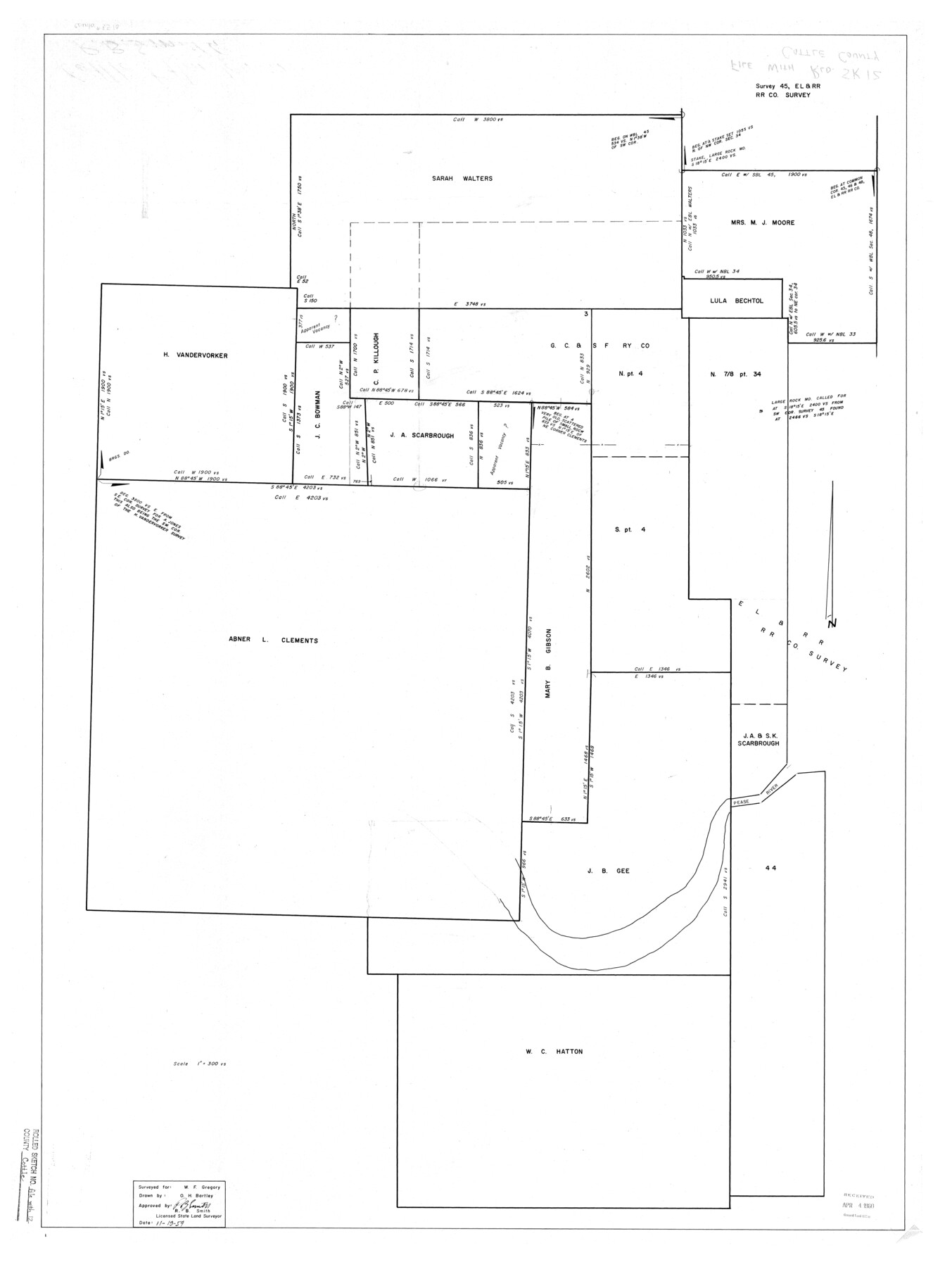
Cottle County Rolled Sketch 12
[Sketch of Abner L. Clements survey and surrounding surveys]
-
Map/Doc
5570
-
Collection
General Map Collection
-
Object Dates
1959/11/19 (Creation Date)
1963/6/1 (File Date)
-
People and Organizations
R.B. Smith (Surveyor/Engineer)
O.H. Bartley (Draftsman)
-
Counties
Cottle Hardeman
-
Subjects
Surveying Rolled Sketch
-
Height x Width
41.1 x 30.9 inches
104.4 x 78.5 cm
-
Scale
1" = 300 varas
Part of: General Map Collection
Culberson County Sketch File 32

Print $22.00
- Digital $50.00
Culberson County Sketch File 32
1952
Size 11.2 x 8.7 inches
Map/Doc 20285
Angelina County Sketch File 15c

Print $16.00
- Digital $50.00
Angelina County Sketch File 15c
1838
Size 12.2 x 8.0 inches
Map/Doc 12972
Right of Way and Track Map Houston & Texas Central R.R. operated by the T. and N. O. R.R. Co., Fort Worth Branch

Print $40.00
- Digital $50.00
Right of Way and Track Map Houston & Texas Central R.R. operated by the T. and N. O. R.R. Co., Fort Worth Branch
1918
Size 30.7 x 56.4 inches
Map/Doc 64542
Flight Mission No. CGI-1N, Frame 175, Cameron County

Print $20.00
- Digital $50.00
Flight Mission No. CGI-1N, Frame 175, Cameron County
1955
Size 18.7 x 22.2 inches
Map/Doc 84510
Eastland County Working Sketch 61

Print $20.00
- Digital $50.00
Eastland County Working Sketch 61
1989
Size 35.4 x 41.0 inches
Map/Doc 68842
Dallas County Boundary File 3

Print $6.00
- Digital $50.00
Dallas County Boundary File 3
Size 14.2 x 8.6 inches
Map/Doc 52120
Flight Mission No. DIX-6P, Frame 133, Aransas County

Print $20.00
- Digital $50.00
Flight Mission No. DIX-6P, Frame 133, Aransas County
1956
Size 19.6 x 23.3 inches
Map/Doc 83839
Matagorda County Working Sketch Graphic Index, Sheet 1 (Sketches 1 to 16)

Print $40.00
- Digital $50.00
Matagorda County Working Sketch Graphic Index, Sheet 1 (Sketches 1 to 16)
1920
Size 40.0 x 48.8 inches
Map/Doc 76633
Wichita County Working Sketch 26

Print $20.00
- Digital $50.00
Wichita County Working Sketch 26
1981
Size 13.1 x 21.0 inches
Map/Doc 72536
Zavala County Working Sketch 14

Print $20.00
- Digital $50.00
Zavala County Working Sketch 14
1976
Size 20.0 x 12.9 inches
Map/Doc 62089
Galveston County Rolled Sketch 23

Print $24.00
- Digital $50.00
Galveston County Rolled Sketch 23
1955
Size 10.0 x 15.2 inches
Map/Doc 45081
Austin County Sketch File 4a

Print $8.00
- Digital $50.00
Austin County Sketch File 4a
1881
Size 6.5 x 4.9 inches
Map/Doc 13861
You may also like
San Augustine County Working Sketch 15

Print $20.00
- Digital $50.00
San Augustine County Working Sketch 15
1959
Size 26.6 x 36.7 inches
Map/Doc 63703
Washburn situated in Armstrong County, Texas on surveys 62, 63, 98 & 99, Block B4

Print $20.00
- Digital $50.00
Washburn situated in Armstrong County, Texas on surveys 62, 63, 98 & 99, Block B4
Size 44.2 x 31.4 inches
Map/Doc 90261
Flight Mission No. BRE-2P, Frame 63, Nueces County

Print $20.00
- Digital $50.00
Flight Mission No. BRE-2P, Frame 63, Nueces County
1956
Size 18.5 x 22.5 inches
Map/Doc 86758
Bell County Working Sketch 1

Print $20.00
- Digital $50.00
Bell County Working Sketch 1
1915
Size 20.7 x 13.2 inches
Map/Doc 67341
Galveston County NRC Article 33.136 Sketch 71

Print $22.00
- Digital $50.00
Galveston County NRC Article 33.136 Sketch 71
2012
Size 24.0 x 36.0 inches
Map/Doc 94689
Bandera County Working Sketch Graphic Index

Print $40.00
- Digital $50.00
Bandera County Working Sketch Graphic Index
1947
Size 33.5 x 53.8 inches
Map/Doc 76461
Hockley County Sketch File M

Print $20.00
- Digital $50.00
Hockley County Sketch File M
Size 22.2 x 25.8 inches
Map/Doc 11777
The Republic County of Nacogdoches. January 1, 1838

Print $20.00
The Republic County of Nacogdoches. January 1, 1838
2020
Size 17.5 x 21.7 inches
Map/Doc 96244
Burleson County Sketch File 5

Print $4.00
- Digital $50.00
Burleson County Sketch File 5
Size 12.9 x 8.3 inches
Map/Doc 16649
Medina County

Print $40.00
- Digital $50.00
Medina County
1976
Size 50.6 x 40.9 inches
Map/Doc 77370
Presidio County Rolled Sketch 13

Print $40.00
- Digital $50.00
Presidio County Rolled Sketch 13
1882
Size 58.8 x 48.0 inches
Map/Doc 9763
Young County Sketch File 6

Print $14.00
- Digital $50.00
Young County Sketch File 6
Size 13.0 x 8.2 inches
Map/Doc 40852