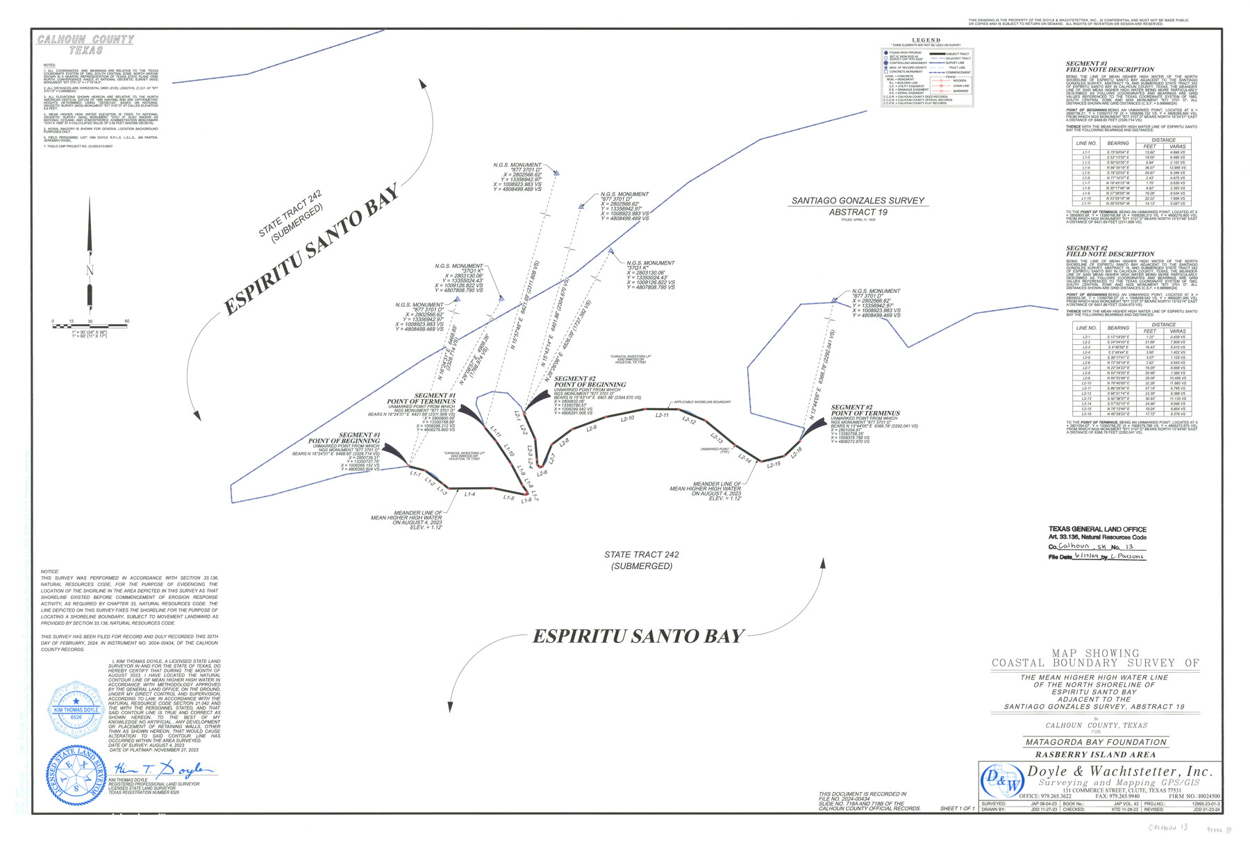
Calhoun County NRC Article 33.136 Sketch 13
Map showing coastal boundary survey of the mean higher high water line of the north shoreline of Espiritu Santo Bay adjacent to the Santiago Gonzales Survey, Abstract 19
-
Map/Doc
97272
-
Collection
General Map Collection
-
Object Dates
11/27/2023 (Creation Date)
6/17/2024 (File Date)
8/4/2023 (Survey Date)
1/23/2024 (Revision Date)
-
People and Organizations
Kim Thomas Doyle (Surveyor/Engineer)
-
Counties
Calhoun
-
Subjects
Surveying CBS
-
Scale
1" = 30 feet
-
Comments
Project: Matagorda Bay Foundation - Rasberry Island Area, Calhoun County
Project No.: TGLO CMP No. 23-020-013-D607
Part of: General Map Collection

Current Miscellaneous File 81

Print $14.00
- Digital $50.00
Current Miscellaneous File 81
1942
Size 14.2 x 8.9 inches
Map/Doc 74217
Presidio County Sketch File 69b

Print $6.00
- Digital $50.00
Presidio County Sketch File 69b
1919
Size 11.2 x 8.8 inches
Map/Doc 34666
Map of Ellis County

Print $20.00
- Digital $50.00
Map of Ellis County
1857
Size 37.7 x 21.4 inches
Map/Doc 4536
Flight Mission No. CZW-1R, Frame 116, Hardeman County

Print $20.00
- Digital $50.00
Flight Mission No. CZW-1R, Frame 116, Hardeman County
1956
Size 18.6 x 19.0 inches
Map/Doc 85235
Map of the State of Texas from the most recent authorities

Print $20.00
- Digital $50.00
Map of the State of Texas from the most recent authorities
1850
Size 13.8 x 17.3 inches
Map/Doc 89251
DeWitt County Working Sketch 6

Print $20.00
- Digital $50.00
DeWitt County Working Sketch 6
1977
Size 30.6 x 26.6 inches
Map/Doc 68596
Flight Mission No. CUG-3P, Frame 143, Kleberg County

Print $20.00
- Digital $50.00
Flight Mission No. CUG-3P, Frame 143, Kleberg County
1956
Size 19.0 x 22.5 inches
Map/Doc 86278
Crockett County Rolled Sketch 79

Print $20.00
- Digital $50.00
Crockett County Rolled Sketch 79
1954
Size 36.1 x 47.8 inches
Map/Doc 76013
Moore County Working Sketch 9

Print $20.00
- Digital $50.00
Moore County Working Sketch 9
1950
Size 38.5 x 31.8 inches
Map/Doc 71191
Live Oak County Working Sketch 37

Print $40.00
- Digital $50.00
Live Oak County Working Sketch 37
2012
Size 34.4 x 48.7 inches
Map/Doc 93363

You may also like
Brazoria County Working Sketch 38

Print $40.00
- Digital $50.00
Brazoria County Working Sketch 38
1981
Size 53.2 x 37.7 inches
Map/Doc 67523
The City of Austin and Suburbs

Print $40.00
- Digital $50.00
The City of Austin and Suburbs
1919
Size 120.7 x 73.5 inches
Map/Doc 2204
Wise County Sketch File 41

Print $4.00
- Digital $50.00
Wise County Sketch File 41
1875
Size 12.8 x 8.1 inches
Map/Doc 40599
Reeves County Working Sketch 65

Print $20.00
- Digital $50.00
Reeves County Working Sketch 65
1990
Size 17.3 x 19.7 inches
Map/Doc 63508
Fisher County Working Sketch 15

Print $20.00
- Digital $50.00
Fisher County Working Sketch 15
1958
Size 22.2 x 22.6 inches
Map/Doc 69149
Flight Mission No. DQN-6K, Frame 7, Calhoun County

Print $20.00
- Digital $50.00
Flight Mission No. DQN-6K, Frame 7, Calhoun County
1953
Size 18.4 x 22.1 inches
Map/Doc 84429
Cameron County Sketch File 7

Print $146.00
- Digital $50.00
Cameron County Sketch File 7
1980
Size 14.3 x 8.7 inches
Map/Doc 17042
[Texas Gulf Coast from Rio Grande to Sabine Lake]
![72686, [Texas Gulf Coast from Rio Grande to Sabine Lake], General Map Collection](https://historictexasmaps.com/wmedia_w700/maps/72686.tif.jpg)
Print $20.00
- Digital $50.00
[Texas Gulf Coast from Rio Grande to Sabine Lake]
Size 28.0 x 18.3 inches
Map/Doc 72686
Chambers County Sketch File 25

Print $8.00
- Digital $50.00
Chambers County Sketch File 25
Size 14.1 x 8.7 inches
Map/Doc 17602
J. De Cordova's Map of the State of Texas Compiled from the records of the General Land Office of the State

Print $20.00
- Digital $50.00
J. De Cordova's Map of the State of Texas Compiled from the records of the General Land Office of the State
1849
Size 36.0 x 34.0 inches
Map/Doc 93930
Terrell County Working Sketch 22a

Print $20.00
- Digital $50.00
Terrell County Working Sketch 22a
1939
Size 39.8 x 40.9 inches
Map/Doc 71493
Sulphur River, Talco Sheet

Print $20.00
- Digital $50.00
Sulphur River, Talco Sheet
1917
Size 24.6 x 43.7 inches
Map/Doc 65160