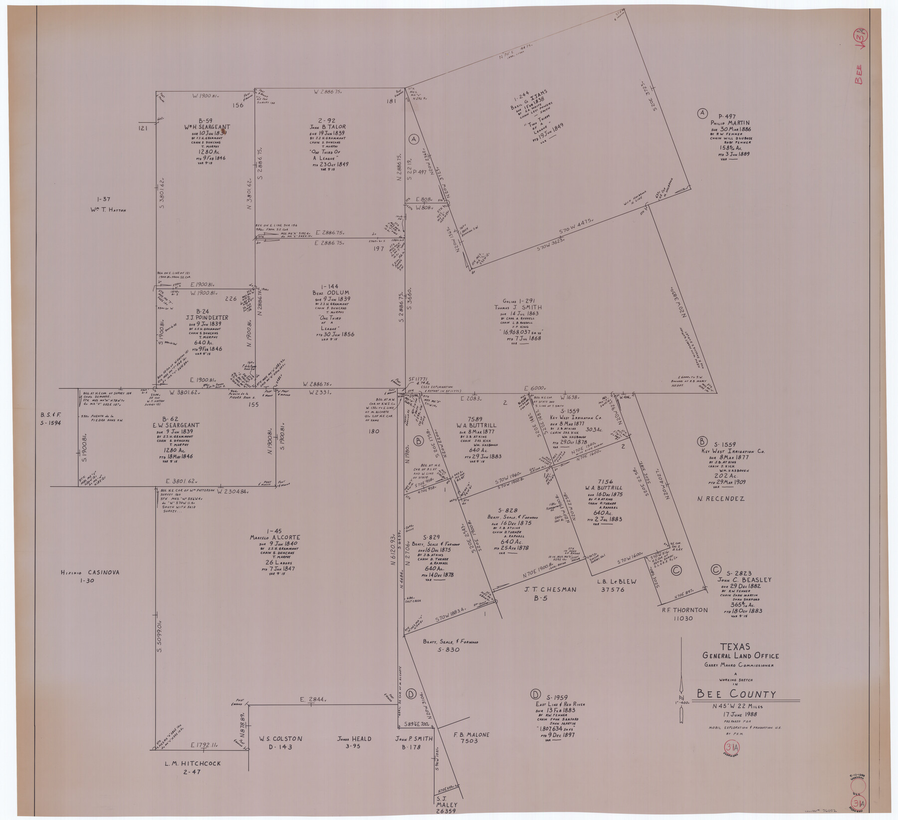
Bee County Working Sketch 31a
-
Map/Doc
76052
-
Collection
General Map Collection
-
Object Dates
6/17/1988 (Creation Date)
-
People and Organizations
Garry Mauro (GLO Commissioner)
Patrick K. Murphy (Draftsman)
-
Counties
Bee
-
Subjects
Surveying Working Sketch
-
Height x Width
39.5 x 43.2 inches
100.3 x 109.7 cm
-
Scale
1" = 400 varas
-
Comments
Surveys located about 22 miles North 45 degrees West of Beeville, Texas.
Part of: General Map Collection
Galveston County Sketch File 1b

Print $6.00
- Digital $50.00
Galveston County Sketch File 1b
1845
Size 16.2 x 11.0 inches
Map/Doc 23347
Flight Mission No. BQY-4M, Frame 36, Harris County

Print $20.00
- Digital $50.00
Flight Mission No. BQY-4M, Frame 36, Harris County
1953
Size 18.6 x 22.3 inches
Map/Doc 85251
Shackelford County Rolled Sketch 4A

Print $40.00
- Digital $50.00
Shackelford County Rolled Sketch 4A
1984
Size 35.2 x 48.7 inches
Map/Doc 9917
Baylor County Sketch File 11C

Print $20.00
- Digital $50.00
Baylor County Sketch File 11C
1892
Map/Doc 88491
Jones County Sketch File 10a

Print $40.00
- Digital $50.00
Jones County Sketch File 10a
1875
Size 40.0 x 50.6 inches
Map/Doc 10509
Flight Mission No. CGI-4N, Frame 177, Cameron County

Print $20.00
- Digital $50.00
Flight Mission No. CGI-4N, Frame 177, Cameron County
1955
Size 18.5 x 22.2 inches
Map/Doc 84680
Chambers County Sketch File 20

Print $4.00
- Digital $50.00
Chambers County Sketch File 20
Size 9.2 x 7.4 inches
Map/Doc 17591
Erath County Rolled Sketch 4

Print $20.00
- Digital $50.00
Erath County Rolled Sketch 4
Size 29.1 x 40.9 inches
Map/Doc 5866
Sectional Map No. 2 of the lands and the line of the Texas & Pacific Ry. Co. in Howard, Martin, Andrews, Midland and Tom Green Counties

Print $20.00
- Digital $50.00
Sectional Map No. 2 of the lands and the line of the Texas & Pacific Ry. Co. in Howard, Martin, Andrews, Midland and Tom Green Counties
1885
Size 19.1 x 23.3 inches
Map/Doc 4862
Flight Mission No. DQN-2K, Frame 123, Calhoun County

Print $20.00
- Digital $50.00
Flight Mission No. DQN-2K, Frame 123, Calhoun County
1953
Size 16.6 x 16.5 inches
Map/Doc 84299
Webb County Rolled Sketch 47

Print $20.00
- Digital $50.00
Webb County Rolled Sketch 47
Size 23.5 x 31.7 inches
Map/Doc 8203
L'Amerique Meridionale, et Septentrionale Dressee selon les derniers Relations et suivant les Nouvelles Decouvertes

Print $20.00
- Digital $50.00
L'Amerique Meridionale, et Septentrionale Dressee selon les derniers Relations et suivant les Nouvelles Decouvertes
1726
Size 18.9 x 24.1 inches
Map/Doc 95134
You may also like
Kimble County Sketch File 16

Print $30.00
- Digital $50.00
Kimble County Sketch File 16
1886
Size 8.5 x 7.9 inches
Map/Doc 28942
Hunt County Sketch File 26

Print $4.00
- Digital $50.00
Hunt County Sketch File 26
1851
Size 8.4 x 12.9 inches
Map/Doc 27124
Flight Mission No. CRC-2R, Frame 194, Chambers County

Print $20.00
- Digital $50.00
Flight Mission No. CRC-2R, Frame 194, Chambers County
1956
Size 18.8 x 22.6 inches
Map/Doc 84772
Upton County Working Sketch 6

Print $20.00
- Digital $50.00
Upton County Working Sketch 6
1909
Size 17.1 x 27.0 inches
Map/Doc 69502
[Surveys in Henderson County, Nacogdoches/Houston District]
![69735, [Surveys in Henderson County, Nacogdoches/Houston District], General Map Collection](https://historictexasmaps.com/wmedia_w700/maps/69735.tif.jpg)
Print $2.00
- Digital $50.00
[Surveys in Henderson County, Nacogdoches/Houston District]
Size 11.0 x 7.9 inches
Map/Doc 69735
Flight Mission No. DQO-11K, Frame 22, Galveston County

Print $20.00
- Digital $50.00
Flight Mission No. DQO-11K, Frame 22, Galveston County
1952
Size 18.8 x 22.5 inches
Map/Doc 85219
Comanche County Sketch File 9

Print $4.00
- Digital $50.00
Comanche County Sketch File 9
1859
Size 6.0 x 9.1 inches
Map/Doc 19068
General Highway Map, Starr County, Texas

Print $20.00
General Highway Map, Starr County, Texas
1961
Size 24.9 x 18.1 inches
Map/Doc 79658
Hartley County

Print $40.00
- Digital $50.00
Hartley County
1923
Size 42.1 x 49.5 inches
Map/Doc 95524
Crockett County Sketch File 47

Print $6.00
- Digital $50.00
Crockett County Sketch File 47
1882
Size 14.3 x 8.8 inches
Map/Doc 19789
Flight Mission No. DIX-5P, Frame 109, Aransas County

Print $20.00
- Digital $50.00
Flight Mission No. DIX-5P, Frame 109, Aransas County
1956
Size 17.8 x 18.1 inches
Map/Doc 83788
Fort Bend County Rolled Sketch T

Print $20.00
- Digital $50.00
Fort Bend County Rolled Sketch T
1930
Size 28.7 x 25.8 inches
Map/Doc 5908