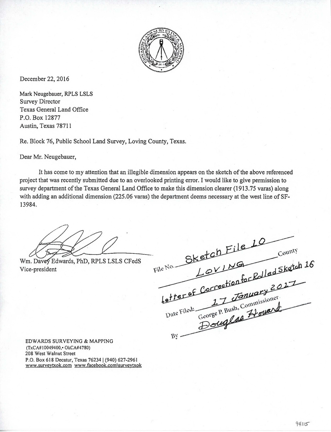
Loving County Sketch File 10
Letter of correction for Rolled Sketch 16
-
Map/Doc
94115
-
Collection
General Map Collection
-
Object Dates
12/22/2016 (Creation Date)
1/17/2017 (File Date)
-
People and Organizations
Wm. Davey Edwards, PhD (Surveyor/Engineer)
-
Counties
Loving
-
Subjects
Surveying Sketch File
-
Height x Width
11.0 x 8.5 inches
27.9 x 21.6 cm
-
Medium
paper, print
-
Comments
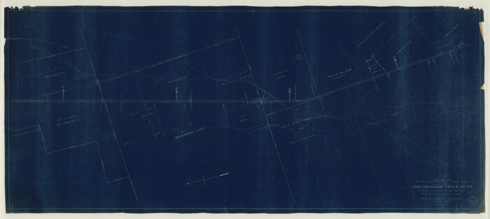
See Loving County Rolled Sketch 16 (94114) for related sketch.
Related maps
Loving County Rolled Sketch 16

Print $20.00
- Digital $50.00
Loving County Rolled Sketch 16
2016
Size 36.3 x 24.6 inches
Map/Doc 94114
Part of: General Map Collection
Galveston County NRC Article 33.136 Sketch 35

Print $42.00
- Digital $50.00
Galveston County NRC Article 33.136 Sketch 35
2005
Size 24.3 x 36.6 inches
Map/Doc 83406
Crockett County Rolled Sketch E

Print $20.00
- Digital $50.00
Crockett County Rolled Sketch E
1907
Size 26.2 x 27.7 inches
Map/Doc 5636
Sutton County Working Sketch 11

Print $40.00
- Digital $50.00
Sutton County Working Sketch 11
1972
Size 76.8 x 45.5 inches
Map/Doc 62354
Trinity County Working Sketch 24

Print $20.00
- Digital $50.00
Trinity County Working Sketch 24
2010
Size 18.2 x 36.5 inches
Map/Doc 89599
Webb County Sketch File 8-1

Print $20.00
- Digital $50.00
Webb County Sketch File 8-1
1929
Size 38.3 x 31.1 inches
Map/Doc 10429
Llano County Rolled Sketch 2

Print $20.00
- Digital $50.00
Llano County Rolled Sketch 2
Size 18.2 x 27.3 inches
Map/Doc 9459
Upton County Working Sketch 15

Print $40.00
- Digital $50.00
Upton County Working Sketch 15
1940
Size 28.4 x 48.6 inches
Map/Doc 69511
Hall County Sketch File 33

Print $16.00
- Digital $50.00
Hall County Sketch File 33
1912
Size 11.4 x 8.7 inches
Map/Doc 24874
Upton County Sketch File 26

Print $20.00
- Digital $50.00
Upton County Sketch File 26
1928
Size 22.6 x 14.2 inches
Map/Doc 12520
Map of Reeves County

Print $20.00
- Digital $50.00
Map of Reeves County
1892
Size 47.2 x 35.4 inches
Map/Doc 78401
Galveston County Rolled Sketch 34D

Print $71.00
- Digital $50.00
Galveston County Rolled Sketch 34D
1981
Size 9.9 x 15.1 inches
Map/Doc 45171
Map showing the fortification at Point Isabel

Print $20.00
- Digital $50.00
Map showing the fortification at Point Isabel
1864
Size 18.3 x 27.9 inches
Map/Doc 72921
You may also like
Nueces County Sketch File 56

Print $113.00
- Digital $50.00
Nueces County Sketch File 56
1973
Size 10.1 x 9.3 inches
Map/Doc 32874
Travis County Sketch File 9

Print $4.00
- Digital $50.00
Travis County Sketch File 9
Size 12.6 x 8.2 inches
Map/Doc 38290
[Lgs. 180-183, 196-198, 105-112, 678-680, 699-701, 141-143]
![90153, [Lgs. 180-183, 196-198, 105-112, 678-680, 699-701, 141-143], Twichell Survey Records](https://historictexasmaps.com/wmedia_w700/maps/90153-1.tif.jpg)
Print $3.00
- Digital $50.00
[Lgs. 180-183, 196-198, 105-112, 678-680, 699-701, 141-143]
1913
Size 14.9 x 9.9 inches
Map/Doc 90153
Wilbarger County Sketch File 3

Print $26.00
- Digital $50.00
Wilbarger County Sketch File 3
Size 7.4 x 13.9 inches
Map/Doc 40166
The Republic County of Milam. Proposed, Late Fall 1837-December 31, 1838

Print $20.00
The Republic County of Milam. Proposed, Late Fall 1837-December 31, 1838
2020
Size 17.4 x 21.6 inches
Map/Doc 96226
Victoria County Working Sketch Graphic Index

Print $20.00
- Digital $50.00
Victoria County Working Sketch Graphic Index
1921
Size 47.0 x 39.0 inches
Map/Doc 76728
[San Antonio & Aransas Pass R.R. Right of Way from Eagle Lake to Brazos River]
![64256, [San Antonio & Aransas Pass R.R. Right of Way from Eagle Lake to Brazos River], General Map Collection](https://historictexasmaps.com/wmedia_w700/maps/64256.tif.jpg)
Print $40.00
- Digital $50.00
[San Antonio & Aransas Pass R.R. Right of Way from Eagle Lake to Brazos River]
1895
Size 30.8 x 124.9 inches
Map/Doc 64256
Harris County Aerial Photograph Index Sheet 10

Print $20.00
- Digital $50.00
Harris County Aerial Photograph Index Sheet 10
1953
Size 22.1 x 16.9 inches
Map/Doc 83704
Right of Way and Track Map, Dayton-Goose Creek Ry. Co., Station 190+00 to Station 401+20
Print $40.00
- Digital $50.00
Right of Way and Track Map, Dayton-Goose Creek Ry. Co., Station 190+00 to Station 401+20
1917
Size 25.4 x 56.8 inches
Map/Doc 64366
Flight Mission No. DAG-23K, Frame 13, Matagorda County

Print $20.00
- Digital $50.00
Flight Mission No. DAG-23K, Frame 13, Matagorda County
1953
Size 18.5 x 22.2 inches
Map/Doc 86475
Liberty County Sketch File 44

Print $2.00
- Digital $50.00
Liberty County Sketch File 44
Size 6.0 x 10.3 inches
Map/Doc 30002
Working Sketch in Deaf Smith County [east of Block K3]
![90605, Working Sketch in Deaf Smith County [east of Block K3], Twichell Survey Records](https://historictexasmaps.com/wmedia_w700/maps/90605-1.tif.jpg)
Print $20.00
- Digital $50.00
Working Sketch in Deaf Smith County [east of Block K3]
1919
Size 15.2 x 27.9 inches
Map/Doc 90605