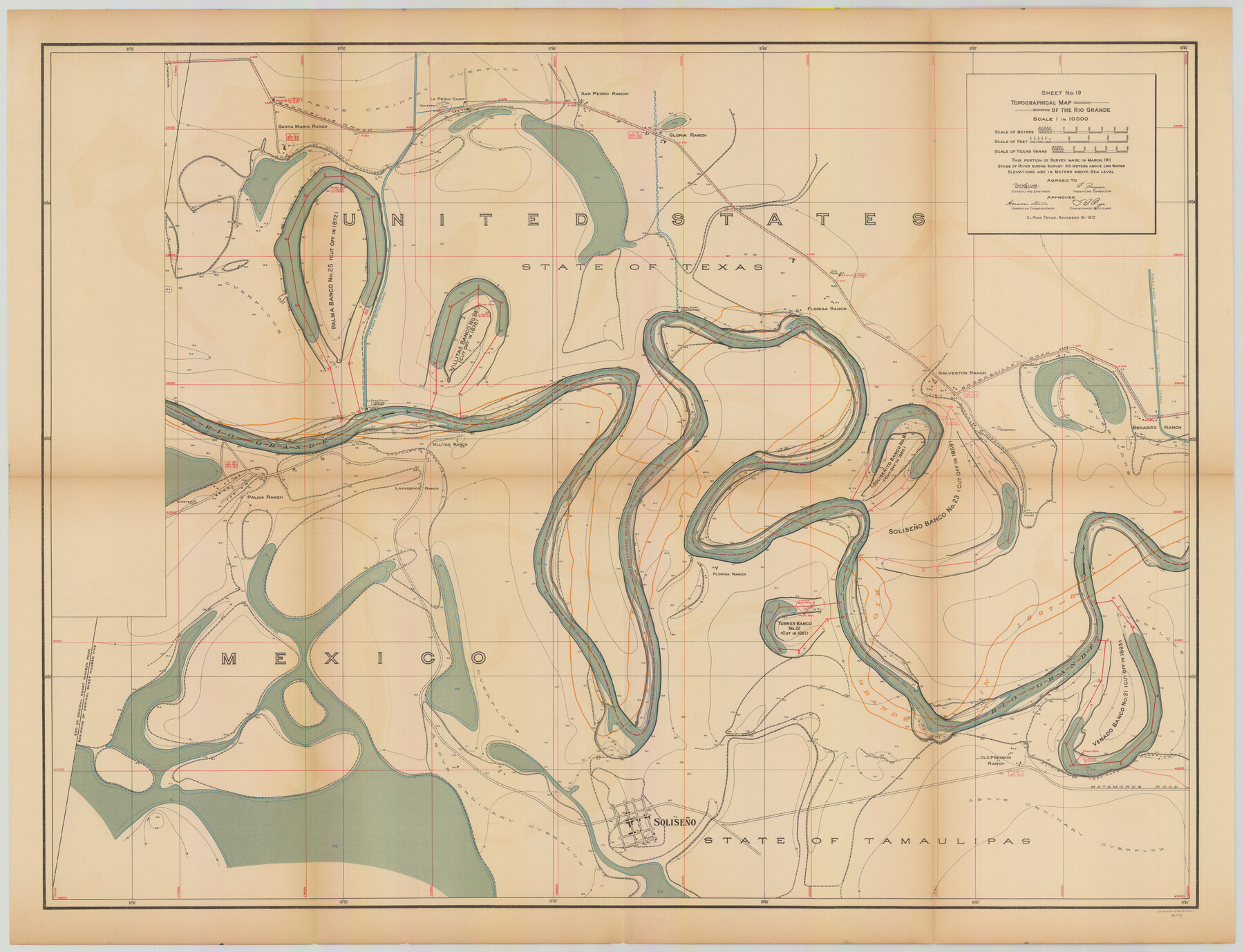
Topographical Map of the Rio Grande, Sheet No. 19
[from book: "Survey of the Rio Grande, Roma to the Gulf of Mexico, Reports and Maps"]
-
Map/Doc
89543
-
Collection
General Map Collection
-
Object Dates
1912/11/16 (Creation Date)
-
People and Organizations
International Boundary Commission (Publisher)
Anson Mills (Author)
E. Zayas (Surveyor/Engineer)
F.B. Puga (Author)
W.W. Follett (Surveyor/Engineer)
-
Subjects
River Surveys Texas Boundaries Topographic
-
Medium
paper
-
Scale
1:10000
-
Comments
This portion of the survey made in March, 1911. State of river during survey 0.3 meters above low water. Elevations are in meters above sea level. This map and 31 others were originally folded and bound into a book titled "Survey of the Rio Grande, R
Part of: General Map Collection
Presidio County Working Sketch 121b

Print $20.00
- Digital $50.00
Presidio County Working Sketch 121b
1984
Size 36.0 x 41.5 inches
Map/Doc 71799
Hamilton County Working Sketch 9

Print $20.00
- Digital $50.00
Hamilton County Working Sketch 9
1946
Size 31.3 x 24.0 inches
Map/Doc 63347
Burleson County Working Sketch 11

Print $20.00
- Digital $50.00
Burleson County Working Sketch 11
1980
Size 18.7 x 17.0 inches
Map/Doc 67730

Harris County Sketch File 76

Print $20.00
- Digital $50.00
Harris County Sketch File 76
1948
Size 22.0 x 15.9 inches
Map/Doc 11665
Right of Way and Track Map Houston & Texas Central R.R. operated by the T. and N. O. R.R. Co., Fort Worth Branch

Print $40.00
- Digital $50.00
Right of Way and Track Map Houston & Texas Central R.R. operated by the T. and N. O. R.R. Co., Fort Worth Branch
1918
Size 31.1 x 57.4 inches
Map/Doc 64540
Nueces River, North Extension Clarkwood Sheet

Print $2.00
- Digital $50.00
Nueces River, North Extension Clarkwood Sheet
1942
Size 14.5 x 17.7 inches
Map/Doc 65100
Flight Mission No. DQN-5K, Frame 58, Calhoun County

Print $20.00
- Digital $50.00
Flight Mission No. DQN-5K, Frame 58, Calhoun County
1953
Size 15.5 x 15.3 inches
Map/Doc 84401
Clay County Sketch File 1

Print $22.00
- Digital $50.00
Clay County Sketch File 1
1855
Size 8.9 x 7.6 inches
Map/Doc 18386
Newton County Working Sketch 30

Print $20.00
- Digital $50.00
Newton County Working Sketch 30
1955
Size 18.2 x 17.8 inches
Map/Doc 71276
Amistad International Reservoir on Rio Grande 67

Print $20.00
- Digital $50.00
Amistad International Reservoir on Rio Grande 67
1949
Size 28.3 x 39.5 inches
Map/Doc 73352
Galveston County Rolled Sketch 46

Print $40.00
- Digital $50.00
Galveston County Rolled Sketch 46
2000
Size 32.0 x 48.3 inches
Map/Doc 5981
You may also like
Erath County Working Sketch 51

Print $20.00
- Digital $50.00
Erath County Working Sketch 51
1986
Size 38.3 x 45.6 inches
Map/Doc 69133
Kinney County Working Sketch 41

Print $20.00
- Digital $50.00
Kinney County Working Sketch 41
1973
Size 36.2 x 44.2 inches
Map/Doc 70223
Orange County Working Sketch 54b

Print $40.00
- Digital $50.00
Orange County Working Sketch 54b
2008
Size 38.0 x 50.3 inches
Map/Doc 88743
San Saba County Working Sketch 10

Print $40.00
- Digital $50.00
San Saba County Working Sketch 10
1985
Size 33.4 x 52.9 inches
Map/Doc 63798
Flight Mission No. CGI-3N, Frame 147, Cameron County

Print $20.00
- Digital $50.00
Flight Mission No. CGI-3N, Frame 147, Cameron County
1954
Size 18.8 x 22.4 inches
Map/Doc 84620
Floyd County Sketch File 7

Print $4.00
- Digital $50.00
Floyd County Sketch File 7
Size 8.9 x 14.3 inches
Map/Doc 22697
Garza County Rolled Sketch 7

Print $11.00
- Digital $50.00
Garza County Rolled Sketch 7
1905
Size 10.0 x 15.4 inches
Map/Doc 45229
Brazos County Working Sketch 10

Print $20.00
- Digital $50.00
Brazos County Working Sketch 10
1991
Size 15.8 x 20.7 inches
Map/Doc 67485
[Map showing Gaines, Dawson, Yoakum, Terry and Lynn Counties]
![92007, [Map showing Gaines, Dawson, Yoakum, Terry and Lynn Counties], Twichell Survey Records](https://historictexasmaps.com/wmedia_w700/maps/92007-1.tif.jpg)
Print $20.00
- Digital $50.00
[Map showing Gaines, Dawson, Yoakum, Terry and Lynn Counties]
Size 24.2 x 20.7 inches
Map/Doc 92007
Fort Bend County Sketch File 3

Print $4.00
- Digital $50.00
Fort Bend County Sketch File 3
Size 12.8 x 8.1 inches
Map/Doc 22880
General Highway Map, Concho County, Texas

Print $20.00
General Highway Map, Concho County, Texas
1940
Size 25.2 x 18.6 inches
Map/Doc 79057
Mitchell County Sketch File 14

Print $20.00
- Digital $50.00
Mitchell County Sketch File 14
1930
Size 17.5 x 20.5 inches
Map/Doc 12101