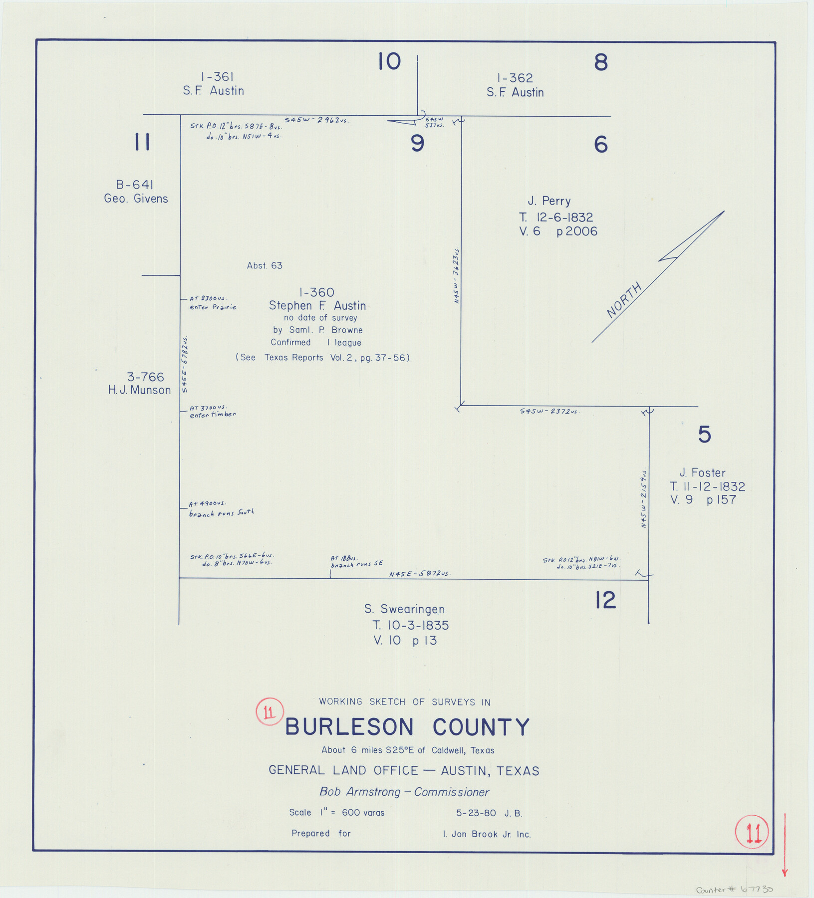
Burleson County Working Sketch 11
-
Map/Doc
67730
-
Collection
General Map Collection
-
Object Dates
5/23/1980 (Creation Date)
-
Counties
Burleson
-
Subjects
Surveying Working Sketch
-
Height x Width
18.7 x 17.0 inches
47.5 x 43.2 cm
-
Scale
1" = 600 varas
Part of: General Map Collection
Padre Island Under Six Flags

Print $40.00
- Digital $50.00
Padre Island Under Six Flags
1962
Size 63.7 x 36.9 inches
Map/Doc 3126
La Salle County Working Sketch 7

Print $20.00
- Digital $50.00
La Salle County Working Sketch 7
1922
Size 35.0 x 36.5 inches
Map/Doc 70308
Sutton County Sketch File 6

Print $8.00
- Digital $50.00
Sutton County Sketch File 6
1897
Size 14.0 x 9.0 inches
Map/Doc 37358
Duval County Sketch File 35b

Print $6.00
- Digital $50.00
Duval County Sketch File 35b
1935
Size 14.4 x 8.8 inches
Map/Doc 21374
Panola County Rolled Sketch 7

Print $20.00
- Digital $50.00
Panola County Rolled Sketch 7
Size 18.6 x 23.4 inches
Map/Doc 7200
Nueces County NRC Article 33.136 Sketch 6

Print $44.00
- Digital $50.00
Nueces County NRC Article 33.136 Sketch 6
2002
Size 23.4 x 35.2 inches
Map/Doc 78658
Upton County Working Sketch 58

Print $20.00
- Digital $50.00
Upton County Working Sketch 58
1988
Size 29.1 x 37.8 inches
Map/Doc 69555
Angelina County Working Sketch 37

Print $20.00
- Digital $50.00
Angelina County Working Sketch 37
1958
Size 25.7 x 19.1 inches
Map/Doc 67120
Wilson County Working Sketch 12

Print $20.00
- Digital $50.00
Wilson County Working Sketch 12
1981
Size 19.5 x 12.9 inches
Map/Doc 72592
Matagorda County Boundary File 1b

Print $6.00
- Digital $50.00
Matagorda County Boundary File 1b
Size 14.2 x 8.5 inches
Map/Doc 56893
Travis County Rolled Sketch 44

Print $20.00
- Digital $50.00
Travis County Rolled Sketch 44
Size 34.2 x 35.6 inches
Map/Doc 10052
Intracoastal Waterway in Texas - Corpus Christi to Point Isabel including Arroyo Colorado to Mo. Pac. R.R. Bridge Near Harlingen

Print $20.00
- Digital $50.00
Intracoastal Waterway in Texas - Corpus Christi to Point Isabel including Arroyo Colorado to Mo. Pac. R.R. Bridge Near Harlingen
1934
Size 22.0 x 32.6 inches
Map/Doc 61886
You may also like
Winkler County Sketch File 5

Print $16.00
- Digital $50.00
Winkler County Sketch File 5
1900
Size 11.2 x 8.7 inches
Map/Doc 40467
Green & Lumsden's Ranch

Print $20.00
- Digital $50.00
Green & Lumsden's Ranch
Size 28.4 x 24.7 inches
Map/Doc 92431
Map of Martin County

Print $20.00
- Digital $50.00
Map of Martin County
1900
Size 41.4 x 36.5 inches
Map/Doc 66918
Flight Mission No. DQN-5K, Frame 145, Calhoun County

Print $20.00
- Digital $50.00
Flight Mission No. DQN-5K, Frame 145, Calhoun County
1953
Size 18.5 x 22.1 inches
Map/Doc 84420
Runnels County Sketch File 16

Print $20.00
Runnels County Sketch File 16
1879
Size 17.0 x 9.1 inches
Map/Doc 35470
Edwards County Working Sketch 14

Print $20.00
- Digital $50.00
Edwards County Working Sketch 14
1924
Size 19.4 x 31.0 inches
Map/Doc 68890
Fannin County Boundary File 10a and 10b and 10c

Print $4.00
- Digital $50.00
Fannin County Boundary File 10a and 10b and 10c
Size 11.2 x 9.0 inches
Map/Doc 53328
Leon County Working Sketch 39

Print $20.00
- Digital $50.00
Leon County Working Sketch 39
1980
Size 35.1 x 42.2 inches
Map/Doc 70438
Zavala County Working Sketch 9

Print $20.00
- Digital $50.00
Zavala County Working Sketch 9
1951
Size 42.0 x 36.4 inches
Map/Doc 62084
Austin County Sketch File 14

Print $40.00
- Digital $50.00
Austin County Sketch File 14
Size 18.8 x 8.8 inches
Map/Doc 13880
Webb County Sketch File 14

Print $7.00
- Digital $50.00
Webb County Sketch File 14
1877
Size 10.0 x 8.2 inches
Map/Doc 39807
Flight Mission No. DQO-8K, Frame 113, Galveston County

Print $20.00
- Digital $50.00
Flight Mission No. DQO-8K, Frame 113, Galveston County
1952
Size 18.6 x 22.5 inches
Map/Doc 85195